20,99 €
inkl. MwSt.
Versandfertig in über 4 Wochen

10 °P sammeln
- Broschiertes Buch
- Merkliste
- Auf die Merkliste
- Bewerten Bewerten
- Teilen
- Produkt teilen
- Produkterinnerung
- Produkterinnerung
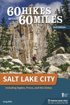
This guide to 60 of the best hikes near Salt Lake City leads you to scenic overlooks, wildlife hot spots, and historical settings.
Andere Kunden interessierten sich auch für
![60 Hikes Within 60 Miles: Sacramento 60 Hikes Within 60 Miles: Sacramento]() Jordan Summers60 Hikes Within 60 Miles: Sacramento20,99 €
Jordan Summers60 Hikes Within 60 Miles: Sacramento20,99 €![60 Hikes Within 60 Miles: Phoenix 60 Hikes Within 60 Miles: Phoenix]() Charles Liu60 Hikes Within 60 Miles: Phoenix20,99 €
Charles Liu60 Hikes Within 60 Miles: Phoenix20,99 €![60 Hikes Within 60 Miles: Boston 60 Hikes Within 60 Miles: Boston]() Lafe Low60 Hikes Within 60 Miles: Boston20,99 €
Lafe Low60 Hikes Within 60 Miles: Boston20,99 €![60 Hikes Within 60 Miles: Baltimore 60 Hikes Within 60 Miles: Baltimore]() Allison Sturm60 Hikes Within 60 Miles: Baltimore21,99 €
Allison Sturm60 Hikes Within 60 Miles: Baltimore21,99 €![60 Hikes Within 60 Miles: Richmond 60 Hikes Within 60 Miles: Richmond]() Philip Riggan60 Hikes Within 60 Miles: Richmond21,99 €
Philip Riggan60 Hikes Within 60 Miles: Richmond21,99 €![60 Hikes Within 60 Miles: Cincinnati 60 Hikes Within 60 Miles: Cincinnati]() Tamara York60 Hikes Within 60 Miles: Cincinnati21,99 €
Tamara York60 Hikes Within 60 Miles: Cincinnati21,99 €![60 Hikes Within 60 Miles: Philadelphia 60 Hikes Within 60 Miles: Philadelphia]() Lori Litchman60 Hikes Within 60 Miles: Philadelphia20,99 €
Lori Litchman60 Hikes Within 60 Miles: Philadelphia20,99 €-
-
-
This guide to 60 of the best hikes near Salt Lake City leads you to scenic overlooks, wildlife hot spots, and historical settings.
Hinweis: Dieser Artikel kann nur an eine deutsche Lieferadresse ausgeliefert werden.
Hinweis: Dieser Artikel kann nur an eine deutsche Lieferadresse ausgeliefert werden.
Produktdetails
- Produktdetails
- Verlag: Menasha Ridge Press
- 3rd Revised edition
- Seitenzahl: 312
- Erscheinungstermin: 11. Juni 2019
- Englisch
- Abmessung: 229mm x 152mm x 20mm
- Gewicht: 454g
- ISBN-13: 9781634041324
- ISBN-10: 1634041321
- Artikelnr.: 53304951
- Herstellerkennzeichnung
- Produktsicherheitsverantwortliche/r
- Europaallee 1
- 36244 Bad Hersfeld
- gpsr@libri.de
Greg Witt has lived the adventures he writes about and shares with audiences around the world. His journeys have taken him to every corner of the globe. He has guided mountaineering expeditions in the Alps and Andes and paddled wild rivers in the Americas. He has dropped teams of adventurers into golden slot canyons; trudged through deep jungles in Africa, Central America, and Asia; and guided archaeological expeditions across the parched Arabian Peninsula. After earning degrees from the University of California and Brigham Young University, Greg had an early career in human-resources management. Preferring high adventure to the high-rise, he traded his wingtips for hiking boots decades ago and has never looked back. Some weeks Greg hikes more miles than he drives, which means he wears out his boots faster than he wears out his tires. He has crossed the Grand Canyon on foot more than a dozen times and climbed Colorado's three highest peaks in three days. Each summer in the Swiss Alps, he hikes more than 700 miles and gains nearly 100,000 vertical feet of elevation as he guides guests of Alpenwild (alpenwild.com), a company he owns and operates. Greg loves leading readers on the most breathtaking hikes and exciting outdoor adventures on the globe. He comes ready to discuss the geology, history, archaeology, weather patterns, culture, flora, and fauna of the exciting locales he loves. His other books include Exploring Havasupai (Menasha Ridge Press), Ultimate Adventures: A Rough Guide to Adventure Travel (Rough Guides), and 50 Best Short Hikes: Utah's National Parks (Wilderness Press). Greg's research and exploration continue to uncover adventures just waiting to be experienced. If you join him, you'll be guaranteed a phenomenal journey.
Overview Map
Acknowledgments
Foreword
Preface
60 Hikes by Category
Introduction
NORTH (Weber County)
* Ben Lomond
* Ogden River Parkway
* Mount Ogden (via Snowbasin Gondola)
* Malans Peak (via Taylor Canyon)
* Waterfall Canyon
NORTH (Davis County)
* Adams Canyon
* Farmington Creek Trail
* Frary Peak
* Kenney Creek Trail
CENTRAL (Salt Lake County)
* Mormon Pioneer Trail
* City Creek Canyon
* Red Butte Garden
* The Living Room (with Red Butte Extension)
* Jack's Mountain
* Lambs Canyon
* Mount Aire
* Grandeur Peak (via the Western Ridge)
* Pipeline Overlook (via Rattlesnake Gulch)
* Grandeur Peak (via Mill Creek Canyon)
* Desolation Trail to Salt Lake Overlook
* Gobblers Knob (via Alexander Basin)
* Mill Creek to Park City Overlook (Including Murdock Peak)
* Neffs Canyon
* Mount Olympus
* Dog Lake
* Desolation Lake
* Mount Raymond (via Butler Fork)
* Broads Fork
* Doughnut Falls
* Lake Blanche
* Willow Heights
* Jordan River Parkway
* Great Western Trail (Guardsman Pass to Clayton Peak)
* Lake Solitude (via the Silver Lake Interpretive Trail)
* Brighton Lakes
* Sunset Peak
* Cecret Lake
* White Pine Lake
* Pfeifferhorn (via Red Pine Lake)
* American Fork Twin Peaks
* Bells Canyon
* Lone Peak (via Jacobs Ladder)
SOUTH (Utah County)
* Silver Lake
* Box Elder Peak
* Timpanogos Cave National Monument
* Mount Timpanogos (via the Timpooneke Trail)
* Emerald Lake and Mount Timpanogos (via Aspen Grove)
* Stewart Falls
* Battle Creek Falls
* Provo River Parkway
* Big Springs Hollow
* Buffalo Peak
* Squaw Peak
* Y Mountain
WEST (Tooele County)
* Stansbury Island
* Deseret Peak
EAST (Summit County and Uintas Mountains)
* Naturalist Basin
* Lofty Lake Loop
* Fehr Lake Trail
* Bald Mountain
Appendix A: Outdoors Shops
Appendix B: Places to Buy Maps
Appendix C: Hiking Clubs
Appendix D: Glossary of Hiking Terms
Index
About the Author
Map Legend
