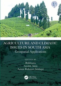
Agriculture and Climatic Issues in South Asia
Geospatial Applications
Herausgeber: Sarkar, Rukhsana; Siddiqui, Azizur Rahman; Alam, Asraful
Agriculture and Climatic Issues in South Asia
Geospatial Applications
Herausgeber: Sarkar, Rukhsana; Siddiqui, Azizur Rahman; Alam, Asraful
- Gebundenes Buch
- Merkliste
- Auf die Merkliste
- Bewerten Bewerten
- Teilen
- Produkt teilen
- Produkterinnerung
- Produkterinnerung
This book details dynamic cropland transformation, agriculture development, climate change and environment with the application of advance geospatial technology. It describes research using geospatial tools and techniques to develop the models, design, and planning for agricultural land use optimization in south Asian countries.
Andere Kunden interessierten sich auch für
![Applications of Small Unmanned Aircraft Systems Applications of Small Unmanned Aircraft Systems]() Applications of Small Unmanned Aircraft Systems174,99 €
Applications of Small Unmanned Aircraft Systems174,99 €![Geospatial Technology for Sustainable Oil Palm Industry Geospatial Technology for Sustainable Oil Palm Industry]() Kasturi KanniahGeospatial Technology for Sustainable Oil Palm Industry166,99 €
Kasturi KanniahGeospatial Technology for Sustainable Oil Palm Industry166,99 €![Scale in Spatial Information and Analysis Scale in Spatial Information and Analysis]() Jingxiong ZhangScale in Spatial Information and Analysis287,99 €
Jingxiong ZhangScale in Spatial Information and Analysis287,99 €![Re-envisioning Advances in Remote Sensing Re-envisioning Advances in Remote Sensing]() Re-envisioning Advances in Remote Sensing174,99 €
Re-envisioning Advances in Remote Sensing174,99 €![Spatial Data Analysis in Ecology and Agriculture Using R Spatial Data Analysis in Ecology and Agriculture Using R]() Richard E PlantSpatial Data Analysis in Ecology and Agriculture Using R155,99 €
Richard E PlantSpatial Data Analysis in Ecology and Agriculture Using R155,99 €![Rainfed Agriculture Rainfed Agriculture]() R K NanwalRainfed Agriculture176,99 €
R K NanwalRainfed Agriculture176,99 €![The Water, Food, Energy and Climate Nexus The Water, Food, Energy and Climate Nexus]() The Water, Food, Energy and Climate Nexus197,99 €
The Water, Food, Energy and Climate Nexus197,99 €-
-
-
This book details dynamic cropland transformation, agriculture development, climate change and environment with the application of advance geospatial technology. It describes research using geospatial tools and techniques to develop the models, design, and planning for agricultural land use optimization in south Asian countries.
Hinweis: Dieser Artikel kann nur an eine deutsche Lieferadresse ausgeliefert werden.
Hinweis: Dieser Artikel kann nur an eine deutsche Lieferadresse ausgeliefert werden.
Produktdetails
- Produktdetails
- Verlag: CRC Press
- Seitenzahl: 424
- Erscheinungstermin: 22. Dezember 2023
- Englisch
- Abmessung: 254mm x 178mm x 25mm
- Gewicht: 998g
- ISBN-13: 9781032428338
- ISBN-10: 1032428333
- Artikelnr.: 69029904
- Herstellerkennzeichnung
- Libri GmbH
- Europaallee 1
- 36244 Bad Hersfeld
- gpsr@libri.de
Rukhsana Sarkar is an Assistant Professor and former Head of the Department of Geography at Aliah University, Kolkata. She has twelve years of teaching as well as research experience. She obtained her M.A., Ph.D. degrees in Geography from Aligarh Muslims University. She was awarded nine academic awards and fellowships like International Young Geographer Award 2009, the AMU-JRF award 2006-07, and UGC-RF 2007-2009 award, etc. Her specialization in research is agriculture development and planning, urban expansion and planning, environment, rural development, RS, and GIS. Presently she is working as project director on a major research project sponsored by ICSSR New Delhi, India. Asraful Alam is an Assistant Professor and HoD at the Department of Geography, Serampore Girls' College, University of Calcutta, West Bengal, India. He received his M.A. & Ph.D. degrees in Geography from Aligarh Muslim University, Aligarh and Aliah University, Kolkata, India respectively and also completed PG Diploma in Remote Sensing & GIS. His research interests include Population Geography, Agricultural Geography, Climatology, Health Geography and Remote Sensing & GIS and Developmental Studies. He has authored jointly edited books entitled Habitat, Ecology and Ekistics: Case Studies of Human-Environment Interactions in India, Agriculture, Food and Nutrition Security: Case Study of Availability and Sustainability in India, Agriculture, Environment and Sustainable Development: Experiences and Case Studies, Life and Living through Newer Spectrum of Geography, Self-Reliance (Atmanirbhar) and Sustainable Resource Management in India, and Climate Change, Agriculture and Society - Approaches toward Sustainability. Dr. Alam has served as an Editorial Board Member in peer-reviewed International Journal of PLOS One, Earth Science, Scientific Journal of Health Science Research and Frontiers in Geochemistry . Azizur Rahman Siddiqui received his M.Sc, M.Phil and D.Phil from Aligarh Muslim University. He also completed a postgraduate diploma in Geoinformation Science and Earth Observation specialization. Dr. Siddiqui enjoyed a university fellowship for two years and was appointed as a permanent lecturer in NREC P. G. College, Khurja Bulandshahar, C. C. S. University, Meerut in 1999 and later joined the Department of Geography, the University of Allahabad from 200. His specialization is in arid zone research, environmental geography, agricultural geography, urban geography, and the application of remote sensing and GIS in land degradation studies. He has published 50 research papers in peer-reviewed journals and is also the author of four books. He is the recipient of the Excellence Award for the year 2018 conferred by the University of Allahabad. He is the recipient of Dr. Sarvapalli Radha krishnan award conferred by didiji foundation (2022) and also recipient of bhugol Bhushan award conferred by deccan geographical society (2022).
Part I: Mapping of Cropland and Agriculture Transformation. Chapter I.
Agriculture Transformation and climatic issues using Geospatial Technology:
An Overview. Chapter II. A Deep Learning Framework for Extraction of Crop
and Forests Cover from Multispectral Remote Sensing Images. Chapter III.
Crop Pattern Mapping using GIS and Remote Sensing: A case study from Multan
District of Pakistan. Chapter IV. Shrinking of Cropland in Asansol Urban
Agglomeration Using Geospatial Approach. Chapter V. Fuzzy-Model-Based
Spatio-Temporal Characterization of Dalbergia sissoo in Doon Valley:
Post-Classification Approach. Chapter VI. Encroachment on Agricultural Land
by Horizontal Development of Built-up Area: A Case Study of Sagar Island,
East Coast of India. Chapter VII. Consequences of agricultural land
transformation on the natives of a planned town- A case study of New Town,
Kolkata. Part II: Forest Vegetation, Disaster Resilient and Sustainable
development. Chapter VIII. Analysis of Demographic Vulnerability and
Women's Participation to Promote Disaster Resilient Society Based on
Disaster Preparedness Behavior of South West Coastal Bangladesh. Chapter
IX. Evaluating Agricultural Drought in the Purulia District, West Bengal
(India): An Earth Observation Perspective. Chapter X. Sectorial
Vulnerability of Climate Change in Ziro Valley of Arunachal Pradesh, India.
Chapter XI. A Comparative Analysis of Social Capital for Reducing the
Effect of Disaster on Social Vulnerabilities in Southwest Coastal
Bangladesh: A Social Exchange Theory Approach. Chapter XII. Spatio-temporal
Analysis of Urban Growth on North Guwahati's Forest and Agricultural Land.
Chapter XIII. Assessing Impact of Super Cyclone Amphan on Natural
Vegetation in Sundarban Biosphere Reserve, India. Chapter XIV. Estimation
of Surface runoff by SCS-CN method in the Sanjai river basin, Jharkhand.
Chapter XV. Impact of Landuse Change on Rural Development: A Study of
Population Dynamics in Canning - I Block South 24 Parganas West Bengal,
India. Part III: Application of remote sensing and GIS based approach in
agriculture practice and climatic issues. Chapter XVI. Application of Fuzzy
machine learning model for mapping diseased 2 sugarcane ratoon fields.
Chapter XVII. Comparative assessment of Landslide Risk modelling by
bivariate model in East Sikkim Himalaya, India. Chapter XVIII. Using
Geospatial Techniques for Detection of Landuse/Cover Changes Due to Major
Hydropower Projects in Upper Beas River Basin, District Kullu, Himachal
Pradesh, India. Chapter XIX. Forecasting the effects of urban expansion on
the agricultural and forest landscape Using MLPNN- Markov Chain Model in
Greater Guwahati Metropolitan Area, India. Chapter XX. Soil erosion and
Digital Soil Mapping, a case study in Garhbeta and its adjoining areas of
West Medinipur. Chapter XXI. Geographical Analysis of Animal Health
Facilities in Nagaur District of Rajasthan. Chapter XXII. Morphometric
Parameters Based Flood Susceptibility Mapping and 1-D Simulation Modelling
of Adyar Watershed, Chennai Basin- A Geo-Spatial Approach. Chapter XXIII.
Assessment of extreme climatic impact on agricultural livelihood in the
Purulia district of West Bengal through multi-criteria decision model.
Chapter XXIV. Assessment and Possible Mitigation Strategy of Climate Change
and Urban Heat Island Using GIS & Remote Sensing: A Case Study of Agartala
City

