47,99 €
inkl. MwSt.
Versandkostenfrei*
Versandfertig in 1-2 Wochen
payback
24 °P sammeln
  • Broschiertes Buch

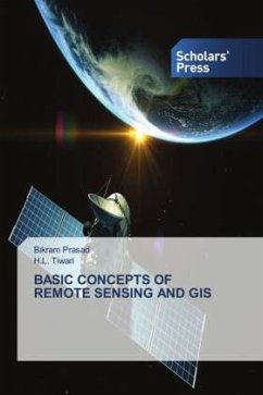
Book deals with the most relevant topic Remote Sensing and GIS in very simple wording so that student can learn the concept very easily. The book comprises of 7 chapters giving detail information about Concept of Remote Sensing, Satellite image Processing and GIS. The book is essentially an undergraduate textbook in the subject area of Geoinformatics, in its present form it also serves as a useful reference book for post-graduate students and scientist in the domain of Remote Sensing and GIS

Produktbeschreibung
Book deals with the most relevant topic Remote Sensing and GIS in very simple wording so that student can learn the concept very easily. The book comprises of 7 chapters giving detail information about Concept of Remote Sensing, Satellite image Processing and GIS. The book is essentially an undergraduate textbook in the subject area of Geoinformatics, in its present form it also serves as a useful reference book for post-graduate students and scientist in the domain of Remote Sensing and GIS
Hinweis: Dieser Artikel kann nur an eine deutsche Lieferadresse ausgeliefert werden.
Autorenporträt
Dr Bikram PrasadCurrently Working as Associate Professor in Civil Engineering Department, BIST, Bhopal.  Expert in RS & GIS, Hydrology & WRE.Dr H.L. TiwariCurrently Working as Associate Professor in Civil Engineering Department, MANIT, Bhopal. Published more than 200 research papers. Expert in WRE, Fluid Mechanics & Hydraulics and Hydrology.