236,99 €
inkl. MwSt.
Versandkostenfrei*
Versandfertig in über 4 Wochen
  • Gebundenes Buch

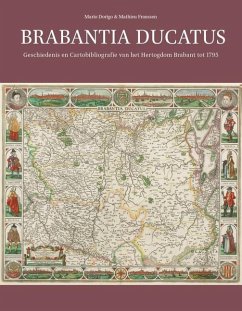
This catalogue of printed maps of the Duchy of Brabant includes all the maps published between 1536, the date of the earliest mention of a map of Brabant, and 1795, when the feudal duchy was abolished. In Dutch, with an English summary.

Produktbeschreibung
This catalogue of printed maps of the Duchy of Brabant includes all the maps published between 1536, the date of the earliest mention of a map of Brabant, and 1795, when the feudal duchy was abolished. In Dutch, with an English summary.
Hinweis: Dieser Artikel kann nur an eine deutsche Lieferadresse ausgeliefert werden.
Autorenporträt
Mario Dorigo (Arnhem, 1946) studied experimental physics ath the Radboud University Nijmegen. In 1985 he started working at the Ministry of Economic Affairs, which gave him the opportunity to see a lot of the world and visit many national libraries to see their maps and atlasses. He started with collecting maps from Breda, and quickly broadened his passion to Brabant. His work for the 'Stichting Historische Cartografie van de Nederlanden' (foundation for historical cartography of the Netherlands) and his involvement in the cartographic fair in Breda and its expositions brought him in contact with Explokart. Mathieu Franssen (Oirschot, 1950) studied history and civics at the Katholieke Leergangen Tilburg (later Fontys University of Applied Sciences). He started his teaching career during his study, first as a teacher of history and civics, later as a teacher of social studies. He followed a course on historic cartography by professor Günter Schilder at the Utrecht University. From 1998-2008, he was responsible for several expositions in the Grote Kerk at Breda during the European Map Fairs. He is co-author of Guicciardini Illustratus: de kaarten en prenten in Ludovico Guicciardini's 'Beschrijving van de Nederlanden' (Hes & De Graaf, 2001), and has written several articles on historical cartography.