65,99 €
inkl. MwSt.
Versandkostenfrei*
Versandfertig in 1-2 Wochen
payback
33 °P sammeln
  • Broschiertes Buch

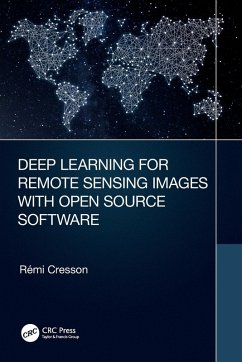
This is the first practical book to introduce deep learning techniques using free open source tools for processing real world remote sensing images. The approaches are generic and adapted to suit applications for various remote sensing images processing in landcover mapping, forestry, urban, in disaster mapping, image restoration, etc.

Produktbeschreibung
This is the first practical book to introduce deep learning techniques using free open source tools for processing real world remote sensing images. The approaches are generic and adapted to suit applications for various remote sensing images processing in landcover mapping, forestry, urban, in disaster mapping, image restoration, etc.
Hinweis: Dieser Artikel kann nur an eine deutsche Lieferadresse ausgeliefert werden.
Autorenporträt
Remi Cresson received the M. Sc. in electrical engineering from the Grenoble Institute of Technology, France, 2009. He is with the Land, Environment, Remote Sensing and Spatial Information Joint Research Unit (UMR TETIS), at the French Research Institute of Science and Technology for Environment and Agriculture (Irstea), Montpellier, France. His research and engineering interests include remote sensing image processing, High Performance Computing, and geospatial data inter-operability. He is member of the Orfeo ToolBox Project Steering Committee and charter member of the Open source geospatial foundation (OSGEO).