29,99 €
inkl. MwSt.
Versandkostenfrei*
Versandfertig in 1-2 Wochen
  • Broschiertes Buch

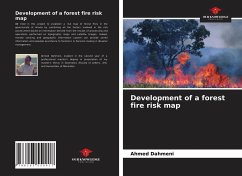
We tried in this project to establish a risk map of forest fires in the governorate of Ariana by combining all the factors involved in the risk assessment based on information derived from the results of processing and operations performed on topographic maps and satellite images. Indeed, remote sensing and geographic information system can provide useful information and valuable assistance to foresters in decision-making in disaster management.

Produktbeschreibung
We tried in this project to establish a risk map of forest fires in the governorate of Ariana by combining all the factors involved in the risk assessment based on information derived from the results of processing and operations performed on topographic maps and satellite images. Indeed, remote sensing and geographic information system can provide useful information and valuable assistance to foresters in decision-making in disaster management.
Hinweis: Dieser Artikel kann nur an eine deutsche Lieferadresse ausgeliefert werden.
Autorenporträt
Ahmed Dahmeni, estudiante de segundo año de máster profesional que prepara su tesis de máster en Geomática (Facultad de Letras, Artes y Humanidades de Manouba).