22,99 €
inkl. MwSt.

Versandfertig in über 4 Wochen
  • Landkarte

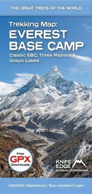
The best sheet map for the Everest treks: Classic EBC, Three Passes & Gokyo Lakes (all clearly colour coded). 1:40,000 - larger scale and more detail than any other Everest map. Perfect for planning and navigation. Includes walk-in route to Lukla Made specifically for the Everest treks by Knife Edge Outdoor Guidebooks: - English/French/German map key - 1:40,000 - Numerous variants, side-routes & day-hikes - Includes free GPX downloads for the trail - GPS compatible - Tougher than traditional maps: try to tear me! - More water-resistant than traditional maps - Lighter than traditional maps - Huts/accommodation marked on the map…mehr

Produktbeschreibung
The best sheet map for the Everest treks: Classic EBC, Three Passes & Gokyo Lakes (all clearly colour coded). 1:40,000 - larger scale and more detail than any other Everest map. Perfect for planning and navigation. Includes walk-in route to Lukla Made specifically for the Everest treks by Knife Edge Outdoor Guidebooks: - English/French/German map key - 1:40,000 - Numerous variants, side-routes & day-hikes - Includes free GPX downloads for the trail - GPS compatible - Tougher than traditional maps: try to tear me! - More water-resistant than traditional maps - Lighter than traditional maps - Huts/accommodation marked on the map
Autorenporträt
Andrew McCluggage is an outdoor writer/photographer from Ireland. He has been a keen mountain walker all his life. He lives for part of the year in the French Alps. He has written are variety of trekking guidebooks including Tour du Mont Blanc, Dolomites AV1, West Highland Way, Corsica GR20, Hadrian's Wall Path, Coast to Coast Path, Mallorca GR221, Walker's Haute Route, Tour of the Ecrins National Park (GR54), Walking Chamonix, Northern Ireland, the Mourne Mountains and Walking Brittany. He was a corporate lawyer for 20 years. In 2018 he quit to start Knife Edge Outdoor Guidebooks