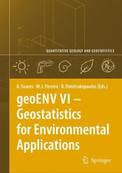
Amílcar Soares / Maria João Pereira / Roussos Dimitrakopoulos (eds.)
geoENV VI ¿ Geostatistics for Environmental Applications
Herausgegeben:Soares, Amílcar; Pereira, Maria João; Dimitrakopoulos, Roussos
Amílcar Soares / Maria João Pereira / Roussos Dimitrakopoulos (eds.)
geoENV VI ¿ Geostatistics for Environmental Applications
Herausgegeben:Soares, Amílcar; Pereira, Maria João; Dimitrakopoulos, Roussos
- Gebundenes Buch
- Merkliste
- Auf die Merkliste
- Bewerten Bewerten
- Teilen
- Produkt teilen
- Produkterinnerung
- Produkterinnerung
This volume contains ca. 40 selected full-text contributions from the Sixth European Conference on Geostatistics for Environmental Applications, geoENV VI, held in Rhodes, Greece, October 25-26, 2006. The objective of the editors was to compile a set of papers from which the reader could perceive how geostatistics is applied within the environmental sciences. A few selected theoretical contributions are also included.
Audience: After six editions the geoENV Congress Series has established itself as a 'must' to all scientists working in the field of geostatistics for environmental…mehr
Andere Kunden interessierten sich auch für
![geoENV VI ¿ Geostatistics for Environmental Applications geoENV VI ¿ Geostatistics for Environmental Applications]() geoENV VI ¿ Geostatistics for Environmental Applications74,99 €
geoENV VI ¿ Geostatistics for Environmental Applications74,99 €![geoENV VII ¿ Geostatistics for Environmental Applications geoENV VII ¿ Geostatistics for Environmental Applications]() P.M. Atkinson / C.D. Lloyd (ed.)geoENV VII ¿ Geostatistics for Environmental Applications110,99 €
P.M. Atkinson / C.D. Lloyd (ed.)geoENV VII ¿ Geostatistics for Environmental Applications110,99 €![geoENV VII ¿ Geostatistics for Environmental Applications geoENV VII ¿ Geostatistics for Environmental Applications]() geoENV VII ¿ Geostatistics for Environmental Applications110,99 €
geoENV VII ¿ Geostatistics for Environmental Applications110,99 €![Geostatistics Tróia '92 Geostatistics Tróia '92]() Geostatistics Tróia '9285,99 €
Geostatistics Tróia '9285,99 €![Geostatistics for Engineers and Earth Scientists Geostatistics for Engineers and Earth Scientists]() Ricardo A. OleaGeostatistics for Engineers and Earth Scientists110,99 €
Ricardo A. OleaGeostatistics for Engineers and Earth Scientists110,99 €![Spatial Modeling Principles in Earth Sciences Spatial Modeling Principles in Earth Sciences]() Zekai SenSpatial Modeling Principles in Earth Sciences110,99 €
Zekai SenSpatial Modeling Principles in Earth Sciences110,99 €![MATLAB® Recipes for Earth Sciences MATLAB® Recipes for Earth Sciences]() Martin TrauthMATLAB® Recipes for Earth Sciences44,99 €
Martin TrauthMATLAB® Recipes for Earth Sciences44,99 €-
-
-
This volume contains ca. 40 selected full-text contributions from the Sixth European Conference on Geostatistics for Environmental Applications, geoENV VI, held in Rhodes, Greece, October 25-26, 2006. The objective of the editors was to compile a set of papers from which the reader could perceive how geostatistics is applied within the environmental sciences. A few selected theoretical contributions are also included.
Audience: After six editions the geoENV Congress Series has established itself as a 'must' to all scientists working in the field of geostatistics for environmental applications. Each geoENV congress covers the developments which have occurred during the preceding two years, but always with a highly applied focus. It is precisely this focus on the applications to environmental sciences which makes the geoENV volumes unique and of great interest and practical value to geostatisticians working both in academia and in industry.
Audience: After six editions the geoENV Congress Series has established itself as a 'must' to all scientists working in the field of geostatistics for environmental applications. Each geoENV congress covers the developments which have occurred during the preceding two years, but always with a highly applied focus. It is precisely this focus on the applications to environmental sciences which makes the geoENV volumes unique and of great interest and practical value to geostatisticians working both in academia and in industry.
Produktdetails
- Produktdetails
- Quantitative Geology and Geostatistics 15
- Verlag: Springer / Springer Netherlands
- Artikelnr. des Verlages: 11974482, 978-1-4020-6447-0
- 2008
- Seitenzahl: 532
- Erscheinungstermin: 11. März 2008
- Englisch
- Abmessung: 241mm x 160mm x 34mm
- Gewicht: 948g
- ISBN-13: 9781402064470
- ISBN-10: 1402064470
- Artikelnr.: 22926789
Amílcar Soares, Instituto Superior Técnico, Lisbon, Portugal / Maria João Pereira, Instituto Superior Técnico, Lisbon, Portugal / Roussos Dimitrakopoulos, McGill University, Montreal, Canada
Environment and Health.- Geostatistical Analysis of Health Data: State-of-the-Art and Perspectives.- Early Detection and Assessment of Epidemics by Particle Filtering.- Improvement of Forecast Noise Levels in Confined Spaces by Means of Geostatistical Methods.- Geostatistical Modeling of Environmental Sound Propagation.- Geostatistical Estimation of Electromagnetic Exposure.- How Spatial Analysis Can Help in Predicting the Level of Radioactive Contamination of Cereals.- Stochastic Modelling Applied to Air Quality Space-Time Characterization.- Automatic Mapping Algorithm of Nitrogen Dioxide Levels from Monitoring Air Pollution Data Using Classical Geostatistical Approach: Application to the French Lille City.- King Prawn Catch by Grade Category from an Economic and a Stock Management Perspective.- Hydrology.- Machine Learning Methods for Inverse Modeling.- Statistical Moments of Reaction Rates in Subsurface Reactive Solute Transport.- Including Conceptual Model Information when Kriging Hydraulic Heads.- Effect of Sorption Processes on Pump-and-Treat Remediation Practices Under Heterogeneous Conditions.- A Stochastic Approach to Estimate Block Dispersivities that Includes the Effect of Mass Transfer Between Grid Blocks.- Fracture Analysis and Flow Simulations in the Roselend Fractured Granite.- Assessment of Groundwater Salinisation Risk Using Multivariate Geostatistics.- A MultiGaussian Kriging Application to the Environmental Impact Assessment of a New Industrial Site in Alcoy (Spain).- Hydrogeological Modeling of Radionuclide Transport in Heterogeneous Low-Permeability Media: A Comparison Between Boom Clay and Ieper Clay.- Topological Kriging of Runoff.- Meteorology.- Quantifying the Impact of the North Atlantic Oscillation on Western Iberia.- Monthly Average Temperature Modelling.- Improving the Areal Estimation of Rainfall in Galicia (NW Spain) Using Digital Elevation Information.- Identification of Inhomogeneities in Precipitation Time Series Using Stochastic Simulation.- Bayesian Classification of a Meteorological Risk Index for Forest Fires: DSR.- Remote Sensing.- Super Resolution Mapping with Multiple Point Geostatistics.- Super-Resolution Mapping Using the Two-Point Histogram and Multi-Source Imagery.- Dating Fire Events on End of Season Maps of Burnt Scars.- Influence of Climate Variability on Wheat Production in Portugal.- Soil.- Joint Simulation of Mine Spoil Uncertainty for Rehabilitation Decision Making.- Temporal Geostatistical Analyses of N2O Fluxes from Differently Treated Soils.- Zinc Baseline Level and its Relationship with Soil Texture in Flanders, Belgium.- Assessing the Quality of the Soil by Stochastic Simulation.- Interpolation of Soil Moisture Content Aided by FDR Sensor Observations.- Geostatistics for Contaminated Sites and Soils: Some Pending Questions.- Evaluation of an Automatic Procedure Basedon Geostatistical Methods for the Characterization of Contaminated Sediments.- Methods.- Nonlinear Spatial Prediction with Non-Gaussian Data: A Maximum Entropy Viewpoint.- Data Fusion in a Spatial Multivariate Framework: Trading off Hypotheses Against Information.- The Challenge of Real-Time Automatic Mapping for Environmental Monitoring Network Management.- Geostatistical Applications of Spartan Spatial Random Fields.- A New Parallelization Approach for Sequential Simulation.- Clustering in Environmental Monitoring Networks: Dimensional Resolutions and Pattern Detection.
Environment and Health.- Geostatistical Analysis of Health Data: State-of-the-Art and Perspectives.- Early Detection and Assessment of Epidemics by Particle Filtering.- Improvement of Forecast Noise Levels in Confined Spaces by Means of Geostatistical Methods.- Geostatistical Modeling of Environmental Sound Propagation.- Geostatistical Estimation of Electromagnetic Exposure.- How Spatial Analysis Can Help in Predicting the Level of Radioactive Contamination of Cereals.- Stochastic Modelling Applied to Air Quality Space-Time Characterization.- Automatic Mapping Algorithm of Nitrogen Dioxide Levels from Monitoring Air Pollution Data Using Classical Geostatistical Approach: Application to the French Lille City.- King Prawn Catch by Grade Category from an Economic and a Stock Management Perspective.- Hydrology.- Machine Learning Methods for Inverse Modeling.- Statistical Moments of Reaction Rates in Subsurface Reactive Solute Transport.- Including Conceptual Model Information when Kriging Hydraulic Heads.- Effect of Sorption Processes on Pump-and-Treat Remediation Practices Under Heterogeneous Conditions.- A Stochastic Approach to Estimate Block Dispersivities that Includes the Effect of Mass Transfer Between Grid Blocks.- Fracture Analysis and Flow Simulations in the Roselend Fractured Granite.- Assessment of Groundwater Salinisation Risk Using Multivariate Geostatistics.- A MultiGaussian Kriging Application to the Environmental Impact Assessment of a New Industrial Site in Alcoy (Spain).- Hydrogeological Modeling of Radionuclide Transport in Heterogeneous Low-Permeability Media: A Comparison Between Boom Clay and Ieper Clay.- Topological Kriging of Runoff.- Meteorology.- Quantifying the Impact of the North Atlantic Oscillation on Western Iberia.- Monthly Average Temperature Modelling.- Improving the Areal Estimation of Rainfall in Galicia (NW Spain) Using Digital Elevation Information.- Identification of Inhomogeneities in Precipitation Time Series Using Stochastic Simulation.- Bayesian Classification of a Meteorological Risk Index for Forest Fires: DSR.- Remote Sensing.- Super Resolution Mapping with Multiple Point Geostatistics.- Super-Resolution Mapping Using the Two-Point Histogram and Multi-Source Imagery.- Dating Fire Events on End of Season Maps of Burnt Scars.- Influence of Climate Variability on Wheat Production in Portugal.- Soil.- Joint Simulation of Mine Spoil Uncertainty for Rehabilitation Decision Making.- Temporal Geostatistical Analyses of N2O Fluxes from Differently Treated Soils.- Zinc Baseline Level and its Relationship with Soil Texture in Flanders, Belgium.- Assessing the Quality of the Soil by Stochastic Simulation.- Interpolation of Soil Moisture Content Aided by FDR Sensor Observations.- Geostatistics for Contaminated Sites and Soils: Some Pending Questions.- Evaluation of an Automatic Procedure Basedon Geostatistical Methods for the Characterization of Contaminated Sediments.- Methods.- Nonlinear Spatial Prediction with Non-Gaussian Data: A Maximum Entropy Viewpoint.- Data Fusion in a Spatial Multivariate Framework: Trading off Hypotheses Against Information.- The Challenge of Real-Time Automatic Mapping for Environmental Monitoring Network Management.- Geostatistical Applications of Spartan Spatial Random Fields.- A New Parallelization Approach for Sequential Simulation.- Clustering in Environmental Monitoring Networks: Dimensional Resolutions and Pattern Detection.
Environment and Health.- Geostatistical Analysis of Health Data: State-of-the-Art and Perspectives.- Early Detection and Assessment of Epidemics by Particle Filtering.- Improvement of Forecast Noise Levels in Confined Spaces by Means of Geostatistical Methods.- Geostatistical Modeling of Environmental Sound Propagation.- Geostatistical Estimation of Electromagnetic Exposure.- How Spatial Analysis Can Help in Predicting the Level of Radioactive Contamination of Cereals.- Stochastic Modelling Applied to Air Quality Space-Time Characterization.- Automatic Mapping Algorithm of Nitrogen Dioxide Levels from Monitoring Air Pollution Data Using Classical Geostatistical Approach: Application to the French Lille City.- King Prawn Catch by Grade Category from an Economic and a Stock Management Perspective.- Hydrology.- Machine Learning Methods for Inverse Modeling.- Statistical Moments of Reaction Rates in Subsurface Reactive Solute Transport.- Including Conceptual Model Information when Kriging Hydraulic Heads.- Effect of Sorption Processes on Pump-and-Treat Remediation Practices Under Heterogeneous Conditions.- A Stochastic Approach to Estimate Block Dispersivities that Includes the Effect of Mass Transfer Between Grid Blocks.- Fracture Analysis and Flow Simulations in the Roselend Fractured Granite.- Assessment of Groundwater Salinisation Risk Using Multivariate Geostatistics.- A MultiGaussian Kriging Application to the Environmental Impact Assessment of a New Industrial Site in Alcoy (Spain).- Hydrogeological Modeling of Radionuclide Transport in Heterogeneous Low-Permeability Media: A Comparison Between Boom Clay and Ieper Clay.- Topological Kriging of Runoff.- Meteorology.- Quantifying the Impact of the North Atlantic Oscillation on Western Iberia.- Monthly Average Temperature Modelling.- Improving the Areal Estimation of Rainfall in Galicia (NW Spain) Using Digital Elevation Information.- Identification of Inhomogeneities in Precipitation Time Series Using Stochastic Simulation.- Bayesian Classification of a Meteorological Risk Index for Forest Fires: DSR.- Remote Sensing.- Super Resolution Mapping with Multiple Point Geostatistics.- Super-Resolution Mapping Using the Two-Point Histogram and Multi-Source Imagery.- Dating Fire Events on End of Season Maps of Burnt Scars.- Influence of Climate Variability on Wheat Production in Portugal.- Soil.- Joint Simulation of Mine Spoil Uncertainty for Rehabilitation Decision Making.- Temporal Geostatistical Analyses of N2O Fluxes from Differently Treated Soils.- Zinc Baseline Level and its Relationship with Soil Texture in Flanders, Belgium.- Assessing the Quality of the Soil by Stochastic Simulation.- Interpolation of Soil Moisture Content Aided by FDR Sensor Observations.- Geostatistics for Contaminated Sites and Soils: Some Pending Questions.- Evaluation of an Automatic Procedure Basedon Geostatistical Methods for the Characterization of Contaminated Sediments.- Methods.- Nonlinear Spatial Prediction with Non-Gaussian Data: A Maximum Entropy Viewpoint.- Data Fusion in a Spatial Multivariate Framework: Trading off Hypotheses Against Information.- The Challenge of Real-Time Automatic Mapping for Environmental Monitoring Network Management.- Geostatistical Applications of Spartan Spatial Random Fields.- A New Parallelization Approach for Sequential Simulation.- Clustering in Environmental Monitoring Networks: Dimensional Resolutions and Pattern Detection.
Environment and Health.- Geostatistical Analysis of Health Data: State-of-the-Art and Perspectives.- Early Detection and Assessment of Epidemics by Particle Filtering.- Improvement of Forecast Noise Levels in Confined Spaces by Means of Geostatistical Methods.- Geostatistical Modeling of Environmental Sound Propagation.- Geostatistical Estimation of Electromagnetic Exposure.- How Spatial Analysis Can Help in Predicting the Level of Radioactive Contamination of Cereals.- Stochastic Modelling Applied to Air Quality Space-Time Characterization.- Automatic Mapping Algorithm of Nitrogen Dioxide Levels from Monitoring Air Pollution Data Using Classical Geostatistical Approach: Application to the French Lille City.- King Prawn Catch by Grade Category from an Economic and a Stock Management Perspective.- Hydrology.- Machine Learning Methods for Inverse Modeling.- Statistical Moments of Reaction Rates in Subsurface Reactive Solute Transport.- Including Conceptual Model Information when Kriging Hydraulic Heads.- Effect of Sorption Processes on Pump-and-Treat Remediation Practices Under Heterogeneous Conditions.- A Stochastic Approach to Estimate Block Dispersivities that Includes the Effect of Mass Transfer Between Grid Blocks.- Fracture Analysis and Flow Simulations in the Roselend Fractured Granite.- Assessment of Groundwater Salinisation Risk Using Multivariate Geostatistics.- A MultiGaussian Kriging Application to the Environmental Impact Assessment of a New Industrial Site in Alcoy (Spain).- Hydrogeological Modeling of Radionuclide Transport in Heterogeneous Low-Permeability Media: A Comparison Between Boom Clay and Ieper Clay.- Topological Kriging of Runoff.- Meteorology.- Quantifying the Impact of the North Atlantic Oscillation on Western Iberia.- Monthly Average Temperature Modelling.- Improving the Areal Estimation of Rainfall in Galicia (NW Spain) Using Digital Elevation Information.- Identification of Inhomogeneities in Precipitation Time Series Using Stochastic Simulation.- Bayesian Classification of a Meteorological Risk Index for Forest Fires: DSR.- Remote Sensing.- Super Resolution Mapping with Multiple Point Geostatistics.- Super-Resolution Mapping Using the Two-Point Histogram and Multi-Source Imagery.- Dating Fire Events on End of Season Maps of Burnt Scars.- Influence of Climate Variability on Wheat Production in Portugal.- Soil.- Joint Simulation of Mine Spoil Uncertainty for Rehabilitation Decision Making.- Temporal Geostatistical Analyses of N2O Fluxes from Differently Treated Soils.- Zinc Baseline Level and its Relationship with Soil Texture in Flanders, Belgium.- Assessing the Quality of the Soil by Stochastic Simulation.- Interpolation of Soil Moisture Content Aided by FDR Sensor Observations.- Geostatistics for Contaminated Sites and Soils: Some Pending Questions.- Evaluation of an Automatic Procedure Basedon Geostatistical Methods for the Characterization of Contaminated Sediments.- Methods.- Nonlinear Spatial Prediction with Non-Gaussian Data: A Maximum Entropy Viewpoint.- Data Fusion in a Spatial Multivariate Framework: Trading off Hypotheses Against Information.- The Challenge of Real-Time Automatic Mapping for Environmental Monitoring Network Management.- Geostatistical Applications of Spartan Spatial Random Fields.- A New Parallelization Approach for Sequential Simulation.- Clustering in Environmental Monitoring Networks: Dimensional Resolutions and Pattern Detection.
