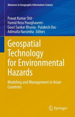
Geospatial Technology for Environmental Hazards
Modeling and Management in Asian Countries
Herausgegeben:Shit, Pravat Kumar; Pourghasemi, Hamid Reza; Bhunia, Gouri Sankar; Das, Pulakesh; Narsimha, Adimalla
Geospatial Technology for Environmental Hazards
Modeling and Management in Asian Countries
Herausgegeben:Shit, Pravat Kumar; Pourghasemi, Hamid Reza; Bhunia, Gouri Sankar; Das, Pulakesh; Narsimha, Adimalla
- Gebundenes Buch
- Merkliste
- Auf die Merkliste
- Bewerten Bewerten
- Teilen
- Produkt teilen
- Produkterinnerung
- Produkterinnerung
The book demonstrates the geospatial technology approach to data mining techniques, data analysis, modeling, risk assessment, visualization, and management strategies in different aspects of natural and social hazards. This book has 25 chapters associated with risk assessment, mapping and management strategies of environmental hazards. It covers major topics such as Landslide Susceptibility, Arsenic Contaminated Groundwater, Earthquake Risk Management, Open Cast Mining, Soil loss, Flood Susceptibility, Forest Fire Risk, Malaria prevalence, Flood inundation, Socio-Economic Vulnerability, River…mehr
Andere Kunden interessierten sich auch für
![Geospatial Technology for Environmental Hazards Geospatial Technology for Environmental Hazards]() Geospatial Technology for Environmental Hazards123,99 €
Geospatial Technology for Environmental Hazards123,99 €![Geo-Environmental Hazards using AI-enabled Geospatial Techniques and Earth Observation Systems Geo-Environmental Hazards using AI-enabled Geospatial Techniques and Earth Observation Systems]() Geo-Environmental Hazards using AI-enabled Geospatial Techniques and Earth Observation Systems108,99 €
Geo-Environmental Hazards using AI-enabled Geospatial Techniques and Earth Observation Systems108,99 €![Spatial Data Handling in Big Data Era Spatial Data Handling in Big Data Era]() Spatial Data Handling in Big Data Era108,99 €
Spatial Data Handling in Big Data Era108,99 €![Spatial Data Handling in Big Data Era Spatial Data Handling in Big Data Era]() Spatial Data Handling in Big Data Era108,99 €
Spatial Data Handling in Big Data Era108,99 €![Advances in Geocomputation Advances in Geocomputation]() Advances in Geocomputation154,99 €
Advances in Geocomputation154,99 €![Proceedings of Workshops and Posters at the 13th International Conference on Spatial Information Theory (COSIT 2017) Proceedings of Workshops and Posters at the 13th International Conference on Spatial Information Theory (COSIT 2017)]() Proceedings of Workshops and Posters at the 13th International Conference on Spatial Information Theory (COSIT 2017)154,99 €
Proceedings of Workshops and Posters at the 13th International Conference on Spatial Information Theory (COSIT 2017)154,99 €![Agent-based Modeling and Simulation in Archaeology Agent-based Modeling and Simulation in Archaeology]() Agent-based Modeling and Simulation in Archaeology77,99 €
Agent-based Modeling and Simulation in Archaeology77,99 €-
-
-
The book demonstrates the geospatial technology approach to data mining techniques, data analysis, modeling, risk assessment, visualization, and management strategies in different aspects of natural and social hazards. This book has 25 chapters associated with risk assessment, mapping and management strategies of environmental hazards. It covers major topics such as Landslide Susceptibility, Arsenic Contaminated Groundwater, Earthquake Risk Management, Open Cast Mining, Soil loss, Flood Susceptibility, Forest Fire Risk, Malaria prevalence, Flood inundation, Socio-Economic Vulnerability, River Bank Erosion, and Socio-Economic Vulnerability. The content of this book will be of interest to researchers, professionals, and policymakers, whose work involves environmental hazards and related solutions.
Produktdetails
- Produktdetails
- Advances in Geographic Information Science
- Verlag: Springer / Springer International Publishing / Springer, Berlin
- Artikelnr. des Verlages: 978-3-030-75196-8
- 1st edition 2022
- Seitenzahl: 612
- Erscheinungstermin: 3. Dezember 2021
- Englisch
- Abmessung: 241mm x 160mm x 36mm
- Gewicht: 1185g
- ISBN-13: 9783030751968
- ISBN-10: 3030751961
- Artikelnr.: 61379531
- Herstellerkennzeichnung Die Herstellerinformationen sind derzeit nicht verfügbar.
Pravat Kumar Shit is an Assistant Professor at the PG Department of Geography, Raja N. L. Khan Women's College (Autonomous), West Bengal, India. He received his M.Sc & Ph.D. degrees in Geography from Vidyasagar University and PG Diploma in Remote Sensing & GIS from Sambalpur University. His research interests include applied geomorphology, soil erosion, groundwater, forest resources, wetland ecosystem, environmental contaminants & pollution, and natural resources mapping & modelling. He has published ten books (eight books in Springer) and more than 60 papers in peer-reviewed journals. He is currently the editor of the GIScience and Geo-environmental Modelling (GGM) Book Series, Springer-Nature. Hamid Reza Pourghasemi is an Associate Professor of Watershed Management Engineering in the College of Agriculture, Shiraz University, Iran. He has a B.Sc. in Watershed Management Engineering from the University of Gorgan (2004), Iran; an M.Sc. in Watershed Management Engineering from Tarbiat Modares University (2008), Iran; and a PhD. in Watershed Management Engineering from the same University (Feb 2014). His main research interests are GIS-based spatial modeling using machine learning/data mining techniques in different fields such as landslide, flood, gully erosion, forest fire, land subsidence, species distribution modeling, and groundwater/hydrology. Also, Hamid Reza works on multi-criteria decision-making methods in natural resources and environment. He has published more than 170 peer-reviewed papers in high-quality journals and four books in Springer and Elsevier as Editor. Also, he is an active reviewer in more of 75 international journals. Gouri Sankar Bhunia received his Ph.D. from the University of Calcutta, India, in 2015. His Ph.D. dissertation work focused on disease transmission modelling using geospatial technology. His research interests include health geography, environmental modeling, risk assessment, data mining, urban planning, and information retrieval using geospatial technology. He is an Associate Editor and on the editorial boards of three international journal in Health GIS and Geosciences. Currently, he is involved various Smart City Planning programme in India. He is also working as a visiting faculty in a private university of West Bengal. He has worked as a 'Resource Scientist' in Bihar Remote Sensing Application Centre, Patna (Bihar, India). He is the recipient of the Senior Research Fellow (SRF) from Rajendra Memorial Research Institute of Medical Sciences (ICMR, India) and has contributed to multiple research programs kala-azar disease transmission modeling, development of customized GIS software for kala-azar 'risk' and 'non-risk' area, and entomological study. He has published more than 60 paper in in reputed peer-reviewed national and international journal and three books in Springer. Pulakesh Das is currently work in World Resources Institute India (WRII), New Delhi India. Previously, he was teaching as an Assistant Professor in the Department of Remote Sensing & GIS, Vidyasagar University, Midnapore, West Bengal, India. He has received his Ph.D. degree from the Indian Institution of Technology (IIT) Kharagpur, India in July 2019. He completed his M.Sc (2012) in Remote Sensing & GIS and B.Sc (2010) in Physics from the Vidyasagar University, Midnapore, West Bengal, India. His primary research area includes Land Use Forest Cover (LUFC) modeling, Hydrological Modeling, Forest Cover Dynamics and Climate Change, Digital Image Processing, Microwave Remote Sensing for Soil Moisture and Forest Biomass Estimation, Plant Biophysical Characterization, etc. He has published more than 15 research articles in reputed peer-reviewed journals and 6 book chapters. Narsimha Adimalla received a Ph.D. from University College of Science, Osmania University, Hyderabad, India in 2012.His Ph.D. dissertation work focused on Geochemistry of groundwater Basara area, Adilabad district, Andhra Pradesh. His research interests include groundwater contaminations, environmental modelling, risk assessment, natural resources mapping and modelling, data mining and information retrieval using Geospatial technology. Now, he is working as a postdoctoral researcher in the School of Environmental Science and Engineering, Chang'an University, China. Dr. Adimalla has published more than 60 articles in various journals in Scopus indexed.
Chapter 1.- Introduction to Part I: Geo-physical Hazards.- Chapter 2-Determination of the Probabilities of Landslide Events -A Case Study.- Chapter 3-Geoinformatics based analysis of landslide stability - A Case Study.- Chapter 4-Land Degradation and Desertification- A Case Study. Chapter 5.- River bank erosion mapping using GIS techniques.- Chapter 6-Geo-spatial modeling of Potential soil erosion estimation for better conservation planning.- Chapter 7-Vulnerability and Risk Assessment of the Bengal Coast, India- a GIS approach.- Chapter 8-Seismic hazard, and vulnerability of assessment for the earthquake scenario-A case study.- Chapter 9-Geo-spatial techniques for mapping, monitoring and modeling shoreline to support coastal risk management.- Chapter 10-Introduction to Part II: Hydro-meteorological Hazards.- Chapter 11-Flood susceptibility analysis based on GIS frequency ratio model.- Chapter 12-Meteorological and agriculture drought monitoring -GIS based approach.- Chapter 13-Geospatial technology and agricultural water resources management.- Chapter 14-Land-Use Suitability Modeling for Agricultural Sustainability.- Chapter 15-Recent trends in climate adaptive water resources management.- Chapter 16-GIS based Spatial analysis on flood modeling - A case study.- Chapter 17-Investigating Vulnerability of Ground Water using AHP and GIS Techniques: A Study.- Chapter 18-Flood Risk zone identification using RS & GIS Techniques.- Chapter 19-Groundwater quality delineation based on Fuzzy Comprehensive Assessment Method.- Chapter 20-Introduction to Part III: Bio-physical Hazards.- Chapter 21-Forest Fire Geo knowledge based Modeling using GIS.- Chapter 22-GI based modelling for wildland fire risk assessment.- Chapter 23-Distribution of Urban Crime Analysis Using GPS, and GIS techniques.- Chapter 24-Analysis of Poverty allocation using Geoinformatics.- Chapter 25-Risk and hazards mapping of Social-economic vulnerability Using GIS techniques.
Chapter 1.- Introduction to Part I: Geo-physical Hazards.- Chapter 2-Determination of the Probabilities of Landslide Events -A Case Study.- Chapter 3-Geoinformatics based analysis of landslide stability - A Case Study.- Chapter 4-Land Degradation and Desertification- A Case Study. Chapter 5.- River bank erosion mapping using GIS techniques.- Chapter 6-Geo-spatial modeling of Potential soil erosion estimation for better conservation planning.- Chapter 7-Vulnerability and Risk Assessment of the Bengal Coast, India- a GIS approach.- Chapter 8-Seismic hazard, and vulnerability of assessment for the earthquake scenario-A case study.- Chapter 9-Geo-spatial techniques for mapping, monitoring and modeling shoreline to support coastal risk management.- Chapter 10-Introduction to Part II: Hydro-meteorological Hazards.- Chapter 11-Flood susceptibility analysis based on GIS frequency ratio model.- Chapter 12-Meteorological and agriculture drought monitoring -GIS based approach.- Chapter 13-Geospatial technology and agricultural water resources management.- Chapter 14-Land-Use Suitability Modeling for Agricultural Sustainability.- Chapter 15-Recent trends in climate adaptive water resources management.- Chapter 16-GIS based Spatial analysis on flood modeling - A case study.- Chapter 17-Investigating Vulnerability of Ground Water using AHP and GIS Techniques: A Study.- Chapter 18-Flood Risk zone identification using RS & GIS Techniques.- Chapter 19-Groundwater quality delineation based on Fuzzy Comprehensive Assessment Method.- Chapter 20-Introduction to Part III: Bio-physical Hazards.- Chapter 21-Forest Fire Geo knowledge based Modeling using GIS.- Chapter 22-GI based modelling for wildland fire risk assessment.- Chapter 23-Distribution of Urban Crime Analysis Using GPS, and GIS techniques.- Chapter 24-Analysis of Poverty allocation using Geoinformatics.- Chapter 25-Risk and hazards mapping of Social-economic vulnerability Using GIS techniques.

