- Gebundenes Buch
- Merkliste
- Auf die Merkliste
- Bewerten Bewerten
- Teilen
- Produkt teilen
- Produkterinnerung
- Produkterinnerung
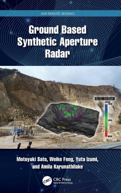
Explains the fundamentals of Ground Based Synthetic Aperture Radar, the principles of Synthetic Aperture Radar (SAR) image generation, and Interferometric SAR (InSAR) processing for observation of small ground surface deformation less than 1 mm, and gives examples of GB-SAR used for landslide monitoring, its potentials, and its limitations.
Andere Kunden interessierten sich auch für
![A New Target Detector Based on Geometrical Perturbation Filters for Polarimetric Synthetic Aperture Radar (POL-SAR) A New Target Detector Based on Geometrical Perturbation Filters for Polarimetric Synthetic Aperture Radar (POL-SAR)]() Armando MarinoA New Target Detector Based on Geometrical Perturbation Filters for Polarimetric Synthetic Aperture Radar (POL-SAR)121,99 €
Armando MarinoA New Target Detector Based on Geometrical Perturbation Filters for Polarimetric Synthetic Aperture Radar (POL-SAR)121,99 €![Polarimetric Synthetic Aperture Radar Polarimetric Synthetic Aperture Radar]() Polarimetric Synthetic Aperture Radar130,99 €
Polarimetric Synthetic Aperture Radar130,99 €![Target Scattering Mechanism in Polarimetric Synthetic Aperture Radar Target Scattering Mechanism in Polarimetric Synthetic Aperture Radar]() Si-Wei ChenTarget Scattering Mechanism in Polarimetric Synthetic Aperture Radar81,99 €
Si-Wei ChenTarget Scattering Mechanism in Polarimetric Synthetic Aperture Radar81,99 €![Target Scattering Mechanism in Polarimetric Synthetic Aperture Radar Target Scattering Mechanism in Polarimetric Synthetic Aperture Radar]() Si-Wei ChenTarget Scattering Mechanism in Polarimetric Synthetic Aperture Radar81,99 €
Si-Wei ChenTarget Scattering Mechanism in Polarimetric Synthetic Aperture Radar81,99 €![Remote Sensing Handbook, Volume V Remote Sensing Handbook, Volume V]() Remote Sensing Handbook, Volume V225,99 €
Remote Sensing Handbook, Volume V225,99 €![Advances in Passive Microwave Remote Sensing of Oceans Advances in Passive Microwave Remote Sensing of Oceans]() Victor RaizerAdvances in Passive Microwave Remote Sensing of Oceans132,99 €
Victor RaizerAdvances in Passive Microwave Remote Sensing of Oceans132,99 €![Deep Learning for Remote Sensing Images with Open Source Software Deep Learning for Remote Sensing Images with Open Source Software]() Rémi CressonDeep Learning for Remote Sensing Images with Open Source Software132,99 €
Rémi CressonDeep Learning for Remote Sensing Images with Open Source Software132,99 €-
-
-
Explains the fundamentals of Ground Based Synthetic Aperture Radar, the principles of Synthetic Aperture Radar (SAR) image generation, and Interferometric SAR (InSAR) processing for observation of small ground surface deformation less than 1 mm, and gives examples of GB-SAR used for landslide monitoring, its potentials, and its limitations.
Hinweis: Dieser Artikel kann nur an eine deutsche Lieferadresse ausgeliefert werden.
Hinweis: Dieser Artikel kann nur an eine deutsche Lieferadresse ausgeliefert werden.
Produktdetails
- Produktdetails
- Verlag: CRC Press
- Seitenzahl: 294
- Erscheinungstermin: 30. Dezember 2024
- Englisch
- Abmessung: 234mm x 156mm x 19mm
- Gewicht: 608g
- ISBN-13: 9781032327068
- ISBN-10: 1032327065
- Artikelnr.: 71235650
- Herstellerkennzeichnung
- Libri GmbH
- Europaallee 1
- 36244 Bad Hersfeld
- gpsr@libri.de
Motoyuki Sato is a professor emeritus at Tohoku University, Japan, and CEO of ALISys Co., Ltd, Japan. He received his B.E., M.E., and Dr. Eng. in information engineering from Tohoku University, Sendai, Japan, in 1980, 1982, and 1985, respectively. From 2007 to 2011 he was a distinguished professor at Tohoku University and from 2009 to 2013 was the director of the Center for Northeast Asian Studies. He was a visiting researcher at the Federal German Institute for Geoscience and Natural Resources (BGR) in Hannover, Germany, in 1988-1989. His current interests include transient electromagnetics and antennas, radar polarimetry, ground-penetrating radar (GPR), borehole radar, electromagnetic induction sensing, and ground-based synthetic aperture radar (GB-SAR) and multiple-input multiple-output (MIMO) radar systems. He developed GPR sensors for humanitarian demining, and they are used in mine-affected countries, including Cambodia and Ukraine. He received the 2014 Frank Frischknecht Leadership Award from society of exploration Geophysicists (SEG) for his sustained and important contributions to near-surface geophysics in the field of ground-penetrating radar. He received the The Institute of Electronics, Information and Communication Engineers (IEICE) Best Paper award in 2017 (Kiyasu Award) and 2020, Achievement Award in 2019, IEEE GRSS Education Award in 2012, and IEEE Ulrich L. Rohde Innovative Conference Paper Awards on Antenna Measurements and Applications in 2017. He was a visiting professor at Jilin University, China; Delft University of Technology, the Netherlands; and the Mongolian University of Science and Technology. Dr. Sato was the general chair of the IEEE International Geoscience and Remote Sensing Symposium (IGARSS) in 2011 in Sendai-Vancouver. Weike Feng is an associate professor at Air Force Engineering University, Shaanxi, China, and the leader of a youth innovation team of Shaanxi universities. He received his B.E. from Air Force Engineering University, Shaanxi, China, in 2013 and his Ph.D. from Tohoku University, Sendai, Japan, in 2019. Dr. Feng received the Young Researcher Award from the IEEE GRSS All Japan Joint Chapter, the Student Award from IEEE AP-S Japan, and the Excellent Paper Award from IET International Radar Conference in 2018, as well as the Professor Fujino Incentive Award from Tohoku University and the Best Student Paper Award from PIERS in 2019. Yuta Izumi received his B. Eng and M. Eng from Chiba University, Japan, in 2016 and 2018, respectively, and his Ph.D. in radar remote sensing from Tohoku University, Japan, in 2021. From 2018 to 2020, he was a JSPS research fellow DC1. From 2019 to 2020, he stayed at the Swiss Federal Institute of Technology (ETH), Zurich, Switzerland. From 2021 to 2022, he was a JSPS research fellow (postdoctoral) at the Institute of Industrial Science, University of Tokyo. He is currently an assistant professor at the Muroran Institute of Technology. His research interests include SAR interferometry and polarimetry and their applications for disaster mitigation and infrastructure health monitoring. Dr. Izumi is a recipient of the Student Paper Award at the ISRS in 2017, President Award from Chiba University in 2018, Dean Award from the Graduate School of Advanced Integration in 2018, Science Young Researcher Award from the IEEE Geoscience and Remote Sensing Society All Japan Joint Chapter in 2019, and Student Poster Award at the IEICE-AP in 2020. Amila Karunathilake is a senior researcher at Advanced Technologies Research Laboratory, Asia Air Survey Co., LTD., Kawasaki, Japan. He received his B.Sc. and M.Sc. from the University of Peradeniya, Kandy, Sri Lanka, in 2011 and 2014, respectively, and his Ph.D. in environmental studies from Tohoku University, Sendai, Japan, in 2017. He was a post-doctoral research fellow with Tohoku University in 2018. He has shown his expertise by involvement in multi-participant disaster prevention research projects under the Cross-Ministerial Strategic Innovation Promotion Program (SIP) from 2019 to 2020. He collaborated with the Ministry of Land, Infrastructure, Transport and Tourism (MLIT) from 2021-2022 in Japan by consulting SAR remote sensing, spatial data processing, and analysis. His research interests include 3D spatial modeling, LiDAR-based mobile mapping systems (MMSs), new algorithms, application development for spaceborne and ground-based synthetic aperture radar, interferometric and polarimetric SAR analysis for infrastructure monitoring, and disaster prevention and mitigation. Dr. Karunathilake was a recipient of the Young Researcher Award from the IEEE GRSS Japan Chapter and the best Ph.D. Student Award from Graduate School of Environmental Studies, Tohoku University, in 2017.

