9,49 €
inkl. MwSt.

Versandfertig in über 4 Wochen
  • Broschiertes Buch

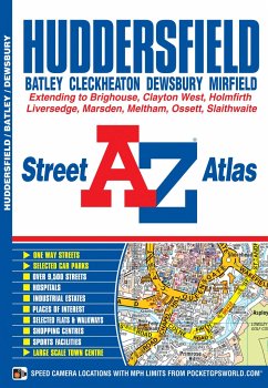
This atlas of Huddersfield features 65 pages of coloured street mapping and covers an area extending to Cleckheaton, Birstall, Batley, Gawthorpe, Ossett, Thornhill, Emley, Clayton West, Skelmanthorpe, Denby Dale, Scholes, Holmfirth, Netherthong, Meltham, Marsden, Slaithwaite, Stainland, Southowram, Brighouse and Hightown.
Produktbeschreibung
This atlas of Huddersfield features 65 pages of coloured street mapping and covers an area extending to Cleckheaton, Birstall, Batley, Gawthorpe, Ossett, Thornhill, Emley, Clayton West, Skelmanthorpe, Denby Dale, Scholes, Holmfirth, Netherthong, Meltham, Marsden, Slaithwaite, Stainland, Southowram, Brighouse and Hightown.
Autorenporträt
A-Z Maps