8,99 €
inkl. MwSt.

Erscheint vorauss. 2. Januar 2025
  • Broschiertes Buch

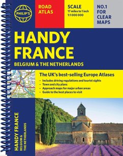
Philip's Handy Road Atlas of France, Belgium and The Netherlands features new digital cartography from Philip's - voted Britain's clearest and most detailed European mapping in an independent consumer survey. This compact A5 atlas with lie-flat binding is perfect for travelling across France and the surrounding countries.

Produktbeschreibung
Philip's Handy Road Atlas of France, Belgium and The Netherlands features new digital cartography from Philip's - voted Britain's clearest and most detailed European mapping in an independent consumer survey. This compact A5 atlas with lie-flat binding is perfect for travelling across France and the surrounding countries.
Hinweis: Dieser Artikel kann nur an eine deutsche Lieferadresse ausgeliefert werden.
Autorenporträt
Philip's has been at the forefront of creating maps and atlases since 1834. Whether a local street map or a fact-packed World Atlas, we use the most up-to-date technology, expertise and our global network to ensure our customers have all the information they need.