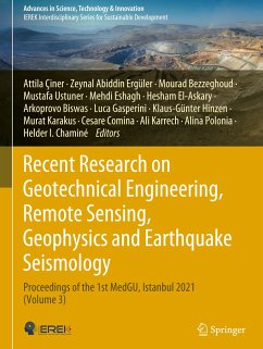
Recent Research on Geotechnical Engineering, Remote Sensing, Geophysics and Earthquake Seismology
Proceedings of the 1st MedGU, Istanbul 2021 (Volume 3)
Herausgegeben:Çiner, Attila; Ergüler, Zeynal Abiddin; Bezzeghoud, Mourad; Ustuner, Mustafa; Eshagh, Mehdi; El-Askary, Hesham; Biswas, Arkoprovo; Gasperini, Luca; Hinzen, Klaus-Günter; Karakus, Murat; Com
- Gebundenes Buch
- Merkliste
- Auf die Merkliste
- Bewerten Bewerten
- Teilen
- Produkt teilen
- Produkterinnerung
- Produkterinnerung
This edited book is based on the accepted papers for presentation at the 1st MedGU Annual Meeting, Istanbul, 2021. With five parts spanning a large spectrum of geological, geotechnical, and geophysical topics, this book presents a series of newest research studies that are nowadays relevant to Middle East, Mediterranean region, and Africa.
The book includes the latest research studies on seismic hazard and risk assessment, earthquake geodesy, seismotectonics, archaeoseismology and active faulting, well logging methods, geodesy and exploration/theoretical geophysics, geological engineering,…mehr
Andere Kunden interessierten sich auch für
![Recent Research on Geotechnical Engineering, Remote Sensing, Geophysics and Earthquake Seismology Recent Research on Geotechnical Engineering, Remote Sensing, Geophysics and Earthquake Seismology]() Recent Research on Geotechnical Engineering, Remote Sensing, Geophysics and Earthquake Seismology193,99 €
Recent Research on Geotechnical Engineering, Remote Sensing, Geophysics and Earthquake Seismology193,99 €![Advances in Research in Geosciences, Geotechnical Engineering, and Environmental Science Advances in Research in Geosciences, Geotechnical Engineering, and Environmental Science]() Advances in Research in Geosciences, Geotechnical Engineering, and Environmental Science131,99 €
Advances in Research in Geosciences, Geotechnical Engineering, and Environmental Science131,99 €![Selected Studies in Geotechnics, Geo-informatics and Remote Sensing Selected Studies in Geotechnics, Geo-informatics and Remote Sensing]() Selected Studies in Geotechnics, Geo-informatics and Remote Sensing177,99 €
Selected Studies in Geotechnics, Geo-informatics and Remote Sensing177,99 €![Collaboration and Integration in Construction, Engineering, Management and Technology Collaboration and Integration in Construction, Engineering, Management and Technology]() Collaboration and Integration in Construction, Engineering, Management and Technology269,99 €
Collaboration and Integration in Construction, Engineering, Management and Technology269,99 €![Collaboration and Integration in Construction, Engineering, Management and Technology Collaboration and Integration in Construction, Engineering, Management and Technology]() Collaboration and Integration in Construction, Engineering, Management and Technology270,99 €
Collaboration and Integration in Construction, Engineering, Management and Technology270,99 €![Recent Research on Environmental Earth Sciences, Geomorphology, Soil Science, Paleoclimate, and Karst Recent Research on Environmental Earth Sciences, Geomorphology, Soil Science, Paleoclimate, and Karst]() Recent Research on Environmental Earth Sciences, Geomorphology, Soil Science, Paleoclimate, and Karst177,99 €
Recent Research on Environmental Earth Sciences, Geomorphology, Soil Science, Paleoclimate, and Karst177,99 €![Recent Research on Environmental Earth Sciences, Geomorphology, Soil Science, Paleoclimate, and Karst Recent Research on Environmental Earth Sciences, Geomorphology, Soil Science, Paleoclimate, and Karst]() Recent Research on Environmental Earth Sciences, Geomorphology, Soil Science, Paleoclimate, and Karst177,99 €
Recent Research on Environmental Earth Sciences, Geomorphology, Soil Science, Paleoclimate, and Karst177,99 €-
-
-
This edited book is based on the accepted papers for presentation at the 1st MedGU Annual Meeting, Istanbul, 2021. With five parts spanning a large spectrum of geological, geotechnical, and geophysical topics, this book presents a series of newest research studies that are nowadays relevant to Middle East, Mediterranean region, and Africa.
The book includes the latest research studies on seismic hazard and risk assessment, earthquake geodesy, seismotectonics, archaeoseismology and active faulting, well logging methods, geodesy and exploration/theoretical geophysics, geological engineering, geotechnical engineering and geoenvironment, geo-informatics, remote sensing and geohazards, basement architecture and potential data, and numerical and analytical methods in mining sciences and geomechanics.
Hinweis: Dieser Artikel kann nur an eine deutsche Lieferadresse ausgeliefert werden.
Produktdetails
- Produktdetails
- Advances in Science, Technology & Innovation
- Verlag: Springer / Springer Nature Switzerland / Springer, Berlin
- Artikelnr. des Verlages: 978-3-031-43217-0
- 2024
- Seitenzahl: 508
- Erscheinungstermin: 13. März 2024
- Englisch
- Abmessung: 285mm x 215mm x 31mm
- Gewicht: 1628g
- ISBN-13: 9783031432170
- ISBN-10: 3031432177
- Artikelnr.: 68498816
- Herstellerkennzeichnung Die Herstellerinformationen sind derzeit nicht verfügbar.
Attila Ciner: Attila Çiner is a sedimentology and Quaternary geology professor at the Eurasia Institute of Earth Sciences at Istanbul Technical University, Turkey. After graduating from the Middle East Technical University in Ankara (1985), he obtained his M.Sc. degree at the University of Toledo, USA (1988), and his Ph.D. at the University of Strasbourg, France (1992). He works on the tectono-sedimentary evolution of basins and Quaternary depositional systems such as moraines, fluvial terraces, alluvial fans, and deltas. He uses cosmogenic nuclides to date these deposits. He primarily focuses on the glacial deposits and landscapes and tries to understand palaeoclimatic and palaeoenvironmental changes since the Last Glacial Maximum. Lastly, he was part of the Turkish Antarctic Expedition. He spent two months working on the site recognition and decision of the future Turkish scientific research station to be implemented on the continent. He is the editor-in-chief of Mediterranean Geoscience Reviews and the chief editor of Arabian J. of Geosciences, both published by Springer. He has published more than 100 peers-reviewed articles and book chapters. Zeynal Abiddin Ergüler: Prof. Dr. Zeynal Abiddin Erguler is a full professor at the geological engineering department at Kutahya Dumlupinar University (Turkey). Dr. Erguler holds a B.Sc. (1998), an M.Sc. (2001), and a Ph.D. degree (2007) in Geological Engineering from Hacettepe University (Turkey). His research interests mainly focus on rock mechanics, engineering geology, environmental geology, and soil mechanics. His current investigation is to understand and model the thermo- hydro-mechanical behaviour of shale rocks in the area of shale gas production. In addition to performing many types of research and industry-funded projects, he has also taught and supervised undergraduate and graduate students. In 2017, Dr. Erguler joined the Arabian Journal of Geosciences (AJGS) as an editor responsible for evaluating submissions in the fields of rock mechanics, engineering geology, environmental geology, and soil mechanics. Mourad Bezzeghoud: Mourad Bezzeghoud is a full professor at the University of Évora (Physics Department/School of Sciences and Technology and a researcher at the ICT/IIIFA). He is, presently, the president of the Scientific Council of the School of Sciences and Technology and the coordinator of the Instituto de Ciências da Terra (ICT) (Univ. of Évora). He has published dozens of articles in specialized revues and journals and several books and chapters in book. He works in the area of Earth Sciences (Solid Earth Geophysics) with an emphasis in seismology. He interacted with more than 198 collaborators in co-authorship of scientific works. He has leading and participated in several international and national research projects and co-organized a number of scientific conferences. He is, presently, an associated editor in Frontiers-Solid Earth Geophysics and the committee member of the Mediterranean Geosciences Union. In his curriculum, Ciência Vitae (https://www.cienciavitae.pt//9715-98D9-D5BB), the most frequent terms in the context of scientific and technological production are: earthquake seismology, seismic source, historical and instrumental seismicity, focal mechanisms, seismic risks, seismotectonics, nonlinear dynamics, seismic network, Ibero-Maghrebian region, and Muography as a new tool for Geophysics. Mustafa Ustuner: He received his Ph.D. in Geomatic Engineering from Yildiz Technical University from Türkiye. He was a short-term visiting researcher in the Geo-Spatial Analytics Lab at the University of South Florida in the USA and was a visiting researcher in the Department of Earth Observation at the Friedrich-Schiller-University of Jena in Germany. Currently, He is working as an assistant professor in the Department of Geomatic Engineering at Artvin Coruh University, Turkey. As an editorial task, he has been serving as an associate editor for the European Journal of Remote Sensing and Arabian Journal of Geosciences. He received the award for Top Reviewers for Geosciences-September 2018 from Publons. Mehdi Eshagh: Mehdi Eshagh is a professor of Geodesy in the department of engineering science at University West, Trollhättan, Sweden. He is interested to work on all geodetic subjects, but Satellite Gravimetry and its applications in the Solid Earth Geophysics are his main field of interest. He uses mathematics and statistics in his research regularly and tries to use these tools to develop new methodologies to solve different geodetic and geophysical problems. Hesham El-Askary: Prof. El-Askary received his Ph.D. in Computational Sciences and Informatics from George Mason University in 2004 along with his two M.S. degrees in Computational sciences and Earth Systems Sciences. In 2015, he earned Chapman University's elite Senior Wang-Fradkin Professorship award. In 2018, he was named a 'Game Changer: Orange County Leaders Transforming the World' by the Orange County Business Council. Prof. El-Askary served as the regional coordinator on a $3 ME project under the Horizon 2020 framework. He currently serves as the vice leader to the dissemination work package in the EU InDUST cost initiative. In 2019, Prof. El-Askary contributed among only 200 scientists worldwide to the IPCC report on the Desertification Chapter. He was also invited by the UN secretariat to the COP14 meeting in New Delhi to present on the sand and dust storms side event and to be part of the global sand and dust storms coalition. Prof. El-Askary has more than 150 peer-reviewed publications, book chapters, and conference paper and raised more than 15M USD in research funds. In 2022, he received 1 M USD from the US congress to advance his Earth Systems Science and Data Solution (EssDs) Lab research on Climate change. ArkoprovoBiswas: Dr. Arkoprovo Biswas is an assistant professor at the Department of Geology, Institute of Science, Banaras Hindu University (BHU), Varanasi. He received his B.Sc. (2002) in Geology from Presidency College, University of Calcutta, M.Sc. (2004) in Geological Science, M.Tech. (2006) in Earth and Environmental Science from IIT Kharagpur, and P.G. Diploma (2009) in Petroleum Exploration from Annamalai University. He joined Geostar Surveys India Pvt., Ltd., as a geophysicist in 2006 and later joined WesternGeco Electromagnetics, Schlumberger as an on-board data processing field engineer/geophysicist in 2007 and served there till 2008. In 2013, he received his Ph.D. in Exploration Geophysics from IIT Kharagpur. Later, he joined the Department of Earth and Environmental Sciences, Indian Institute of Science Education and Research Bhopal as a visiting faculty in 2014 and completed his tenure in 2015. He again joined the Wadia Institute of Himalayan Geology (WIHG) Dehradun in 2016as a research associate and later he joined BHU in October 2017. His main research interest includes Near Surface Geophysics, Integrated Electrical and Electromagnetic Methods, Geophysical Inversion, Mineral, and Groundwater Exploration, and Sub-surface Contamination. Luca Gasperini: Actual Position: Senior Scientist, Istituto di Scienze Marine, ISMAR, Italian National Research Council, Bologna: Adjunct Professor at University of Bologna Main Interests: ¿Geophysical methods; ¿Structural Geology; ¿Seismic Stratigraphy; ¿Plate Tectonic reconstructions; ¿Submarine Paleoseismology. ¿Impact Cratering. Laurea cum laude in Geology (1991), at University of Bologna (Italy). Research scientist at the National Research Council, Institute of Marine Sciences in Bologna, since 1988. He took part, or organized, several oceanographic expeditions, in the Mediterranean Sea and in the Atlantic and Pacific and Sub-Antarctic Oceans. Klaus Günter Hinzen: Klaus-G. Hinzen's main interests are local earthquake seismology, engineering, and particularly archaeoseismology; he worked on source mechanisms of induced and teleseismic earthquakes at the Ruhr-University, Bochum (Ph.D. thesis). During eleven years at the Federal Institute for Geosciences and Natural Resources (BGR), Hannover, he gained experience in seismic in situ testing methods and the modelling of the dynamic behaviour of underground openings. In several projects, he developed methods to reduce environmental effects of blast vibrations. In 1995, he became the director of the Earthquake Geology division of the Institute for Geology and Mineralogy of University of Cologne (BNS). The division runs a local seismic network in the northern Rhine area (NRA) which he expanded to 40 seismic stations including a strong motion network and monitoring of Cologne Cathedral. In several projects, the first instrumental earthquake catalogue of the NRA was published, historical and palaeoseismologicalstudies were made and, a ground amplification model for the southern Lower Rhine Embayment was developed. Since two decades quantitative archaeo¬seismic studies based on laser scan surveys and discrete element modelling in the Rhine area, Turkey, Greece, Italy, Israel, and Tunisia are in the focus of his work which continues after his retirement in 2018 as a professor of the University of Cologne. Murat Karakus: Prof. Karakus holds a B.Sc. in Mining Engineering (1991) from Hacettepe University (Turkey) and a Ph.D. degree in Rock Mechanics (2000) from the University of Leeds, UK. He is currently working at the School of Civil, Environmental and Mining Engineering at the University of Adelaide. His research area is the field of experimental rock mechanics, fracture and damage mechanics, numerical analysis, plasticity and constitutive modelling, and strain burst/rock burst. He established a Cave Mining Research Centre at the University of Adelaide and has been working on many aspects of cave mining, e.g. mud-rush problem, cave backpropagation, preconditioning by hydraulic fracturing, and cave flow modelling. He is currently leading several research projects, including ARC-Australian Research Council grants, CRC-Deep Exploration Technologies, ACARP-Australian Coal Association Research, and industry-supported projects. Prof. Karakus has published several book chapters and over 150 papers in International Journals and Conferences. Prof. Karakus is a member of the ISRM Commission on Rockburst and the ISRM Commission on Deep Mining. He has been serving as the editorial board member of several journals. Cesare Comina: Born in Savigliano, March 13, 1977. From 2005 to 2008, he has been a research associate at Politecnico di Torino where he previously has been graduated in Civil Engineering and awarded of his Ph.D. in Geotechnical Engineering. From 2008 to 2015, he has been an assistant professor in Applied Geophysics at Universitàdegli Studi di Torino. He is currently an associate professor in Applied Geophysics at the same University. In the past, he has carried out his researches at the Department of Structural and Geotechnical Engineering of Politecnico di Torino, where he has collaborated to several funded research projects and participated to the scientific activities of the Geotechnical section. Currently, he pertains to the Department of Earth Sciences at Università degli Studi di Torino and collaborates with the group of Applied Geology. His researches involve the use of different geophysical methods for geotechnical and geological characterization. Ali Karrech: Professor Ali Karrech was a senior research scientist at CSIRO before joining UWA in July 2012. He obtained his Higher Doctorate (Habilitation) in Engineering Sciences from the Ecole Normale Supérieure Paris-Saclay (France) in 2014. He received his Ph.D. in Structures and Materials and his M.Sc. in Mechanics of Solids, Materials, and Structures from the Ecole des Ponts et Chaussées (Paris, France) in 2008 and 2004, respectively. In addition, he graduated with a Master of Engineering from Tunisia Polytechnic School in 2001. At UWA, he has been teaching units related to materials, structures, and resource engineering for more than 10 years. Professor Karrech's research expertise is in materials, structures, multi-physics modelling, minerals processing, and computer methods for resource engineering. Alina Polonia: Alina Polonia, Institute of Marine Sciences-National Research Council (ISMAR-CNR), Bologna, Italy Fields of research: Marine geology and geophysics. Expertise: Tectonics, seismic data interpretation, submarine earthquake geology. Study areas: Calabrian Arc, Marmara Sea, Southern Chile, Eastern Mediterranean. My research aims to study tectonic processes and geohazards of convergent and transform plate margins through a multidisciplinary, multi-scale approach involving geophysical data at different scales (seismic reflection data, multi-beam, gravity, and magnetic data) and sediment cores. The final goal is to reconstruct the interplay between active tectonics, seismic shaking, tsunami wave propagation, fluid flow, and deposition of turbidites in tectonically controlled sedimentary basins. Helder Chaminé: H. I. Chaminé is a skilled geologist and professor of engineering geosciences at the School of Engineering (ISEP) of the Polytechnic of Porto, with over 32 years of experience in multidisciplinary geosciences research, consultancy, and practice. He studied geological engineering and geology (B.Sc., 1990) at the Universities of Aveiro and Porto (Portugal), respectively. He received his Ph.D. in geology at the University of Porto in 2000 and spent his postdoctoral research in applied geosciences at the University of Aveiro (2001-2003). In 2011, he received his Habilitation (D.Sc.) in geosciences from Aveiro University. Before joiningthe academy, he worked for over a decade on international projects for mining, geotechnics, and groundwater industry and/or academia related to geodynamics and regional geology, hard-rock hydrogeology and water resources, engineering geosciences and applied geomorphology, rock engineering, and georesources. His research interests span fundamental to applied fields: GIS mapping techniques for applied geology, structural geology and regional geology, engineering geosciences and rock engineering, slope geotechnics, mining geology and hydrogeomechanics, hard-rock hydrogeology, exploration hydrogeology, urban groundwater, and hydromineral resources. In addition, he has interests in mining geoheritage, the history of cartography, military geosciences and higher-education dissemination, skills, and core values.
Section 1. Geological Engineering, Geotechnical Engineering and Geoenvironment.- Section 2. Geo-Informatics, Remote Sensing and Geohazards.- Section 3. Applied & Theoretical Geophysics.- Section 4. Earthquake Seismology and Geodesy.- Section 5. Numerical and Analytical Methods in Mining Sciences and Geomechanics.
Section 1. Geological Engineering, Geotechnical Engineering and Geoenvironment.- Section 2. Geo-Informatics, Remote Sensing and Geohazards.- Section 3. Applied & Theoretical Geophysics.- Section 4. Earthquake Seismology and Geodesy.- Section 5. Numerical and Analytical Methods in Mining Sciences and Geomechanics.

