Remote Sensing Handbook, Volume II
Image Processing, Change Detection, Gis, and Spatial Data Analysis
Herausgeber: Thenkabail, Prasad S
Remote Sensing Handbook, Volume II
Image Processing, Change Detection, Gis, and Spatial Data Analysis
Herausgeber: Thenkabail, Prasad S
- Gebundenes Buch
- Merkliste
- Auf die Merkliste
- Bewerten Bewerten
- Teilen
- Produkt teilen
- Produkterinnerung
- Produkterinnerung
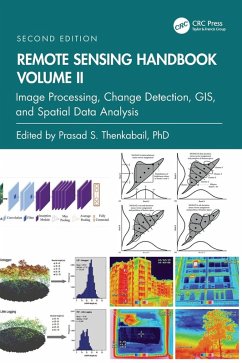
Volume II of the Remote Sensing Handbook, Second Edition, is focused on digital image processing including image classification methods in land cover and land use. It discusses object-based segmentation and pixel-based image processing algorithms, change detection techniques, and image classification for a wide array of applications.
Andere Kunden interessierten sich auch für
![Remote Sensing Handbook, Volume III Remote Sensing Handbook, Volume III]() Remote Sensing Handbook, Volume III272,99 €
Remote Sensing Handbook, Volume III272,99 €![Remote Sensing Handbook, Volume IV Remote Sensing Handbook, Volume IV]() Remote Sensing Handbook, Volume IV218,99 €
Remote Sensing Handbook, Volume IV218,99 €![Remote Sensing Handbook, Volume I Remote Sensing Handbook, Volume I]() Remote Sensing Handbook, Volume I211,99 €
Remote Sensing Handbook, Volume I211,99 €![Remote Sensing Handbook, Volume VI Remote Sensing Handbook, Volume VI]() Remote Sensing Handbook, Volume VI218,99 €
Remote Sensing Handbook, Volume VI218,99 €![Remote Sensing Handbook, Volume V Remote Sensing Handbook, Volume V]() Remote Sensing Handbook, Volume V218,99 €
Remote Sensing Handbook, Volume V218,99 €![Integrating Scale in Remote Sensing and GIS Integrating Scale in Remote Sensing and GIS]() Integrating Scale in Remote Sensing and GIS276,99 €
Integrating Scale in Remote Sensing and GIS276,99 €![Deep Learning for Remote Sensing Images with Open Source Software Deep Learning for Remote Sensing Images with Open Source Software]() Rémi CressonDeep Learning for Remote Sensing Images with Open Source Software126,99 €
Rémi CressonDeep Learning for Remote Sensing Images with Open Source Software126,99 €-
-
-
Volume II of the Remote Sensing Handbook, Second Edition, is focused on digital image processing including image classification methods in land cover and land use. It discusses object-based segmentation and pixel-based image processing algorithms, change detection techniques, and image classification for a wide array of applications.
Hinweis: Dieser Artikel kann nur an eine deutsche Lieferadresse ausgeliefert werden.
Hinweis: Dieser Artikel kann nur an eine deutsche Lieferadresse ausgeliefert werden.
Produktdetails
- Produktdetails
- Verlag: CRC Press
- 2nd edition
- Seitenzahl: 464
- Erscheinungstermin: 29. November 2024
- Englisch
- Abmessung: 254mm x 178mm x 29mm
- Gewicht: 1093g
- ISBN-13: 9781032890975
- ISBN-10: 1032890975
- Artikelnr.: 70941347
- Herstellerkennzeichnung
- Libri GmbH
- Europaallee 1
- 36244 Bad Hersfeld
- gpsr@libri.de
Dr. Prasad S. Thenkabail, Senior Scientist (ST), United States Geological Survey (USGS), is a world-recognized expert in remote sensing science with major contributions in the field for nearly 40 years. He has made the list of the world's top 1% of scientists across 22 scientific fields and 176 sub-fields. Dr. Thenkabail has conducted pioneering research in hyperspectral remote sensing of vegetation, global croplands, and their water use for food security. He obtained his PhD from the Ohio State University in 1992 and has 168 peer-reviewed publications including 15 books, including this six-volume set, and over 15 major data releases such as the Landsat-derived global cropland extent product @ 30m and Landsat-derived rainfed and irrigated cropland area product @ 30 m (LGRIP30). He was recognized as a Fellow of the American Society of Photogrammetry and Remote Sensing (ASPRS) in 2023. His scientific papers have won several awards for demonstrating world-class, highest-quality research. He was a Landsat Science Team Member (2007-2011).
Part I: Image Processing Methods and Approaches. 1. Digital Image
Processing: A Review of the Fundamental Methods and Techniques. 2. Image
Classification Methods in Land Cover and Land Use and Cropland Studies. 3.
Urban Image Classification: Per-pixel Classifiers, Sub-pixel Analysis,
Object-based Image Analysis, and Geospatial Methods. 4. Hyperspectral Image
Processing: Methods and Approaches. 5. Collaborative Representation for
Hyperspectral Image Classification and Detection. 6. Thermal Infrared
Remote Sensing: Principles and Theoretical Background. 7. Remote Sensing
Image Segmentation: Methods, Approaches, and Advances. 8. Object Based
Image Analysis: Evolution, History, State-of-the-Art and Future Vision. 9.
Geospatial Data Integration in OBIA- implications of Accuracy and Validity.
10. Image Segmentation Algorithms for Land Categorization. 11. LiDAR Data
Processing and Applications. Part II: Change Detection. 12. Forest
Clear-Cutting Detection in Subtropical Regions with Time Series Remotely
Sensed Data. Part III: Integrating Geographic Information Systems (GIS) and
Remote Sensing in Spatial Modeling Framework for Decision Support. 13.
Geoprocessing, Workflows, and Provenance. 14. Toward Democratization of
Geographic Information: GIS, Remote Sensing, and GNSS Applications in
Everyday Life. 15. Frontiers of GIScience: Evolution, State-of-Art, and
Future Pathways. 16. Object-Based Regionalization for Policy-Oriented
Partitioning of Space. Part IV: Summary and Synthesis of Volume II. 17.
Remote Sensing Handbook, Volume II: Image Processing, Change Detection, GIS
and Spatial Data Analysis.

