Remote Sensing Handbook
Herausgeber: Thenkabail
Remote Sensing Handbook
Herausgeber: Thenkabail
- Gebundenes Buch
- Merkliste
- Auf die Merkliste
- Bewerten Bewerten
- Teilen
- Produkt teilen
- Produkterinnerung
- Produkterinnerung
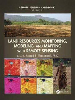
With more than 100 leading global contributors, this book is the most comprehensive documentation of the scientific and methodological advances that have taken place in understanding remote sensing data, methods, and applications over last 50 years. In a very practical way the book demonstrates the experience, utility, methods and models used in studying a wide array of Land applications.
Andere Kunden interessierten sich auch für
![Remote Sensing Image Fusion Remote Sensing Image Fusion]() Luciano AlparoneRemote Sensing Image Fusion206,99 €
Luciano AlparoneRemote Sensing Image Fusion206,99 €![Fuzzy Machine Learning Algorithms for Remote Sensing Image Classification Fuzzy Machine Learning Algorithms for Remote Sensing Image Classification]() Anil KumarFuzzy Machine Learning Algorithms for Remote Sensing Image Classification131,99 €
Anil KumarFuzzy Machine Learning Algorithms for Remote Sensing Image Classification131,99 €![Modeling Invasive Alien Plant Species Modeling Invasive Alien Plant Species]() H O W PeirisModeling Invasive Alien Plant Species152,99 €
H O W PeirisModeling Invasive Alien Plant Species152,99 €![Radar Imaging for Maritime Observation Radar Imaging for Maritime Observation]() Fabrizio BerizziRadar Imaging for Maritime Observation285,99 €
Fabrizio BerizziRadar Imaging for Maritime Observation285,99 €![Remote Sensing and GIS Integration: Theories, Methods, and Applications Remote Sensing and GIS Integration: Theories, Methods, and Applications]() Qihao WengRemote Sensing and GIS Integration: Theories, Methods, and Applications194,99 €
Qihao WengRemote Sensing and GIS Integration: Theories, Methods, and Applications194,99 €![Analysis of Multi-Temporal Remote Sensing Images - Proceedings of the First International Workshop on Multitemp 2001 Analysis of Multi-Temporal Remote Sensing Images - Proceedings of the First International Workshop on Multitemp 2001]() Analysis of Multi-Temporal Remote Sensing Images - Proceedings of the First International Workshop on Multitemp 2001188,99 €
Analysis of Multi-Temporal Remote Sensing Images - Proceedings of the First International Workshop on Multitemp 2001188,99 €![Predictive Analytics in Smart Agriculture Predictive Analytics in Smart Agriculture]() Predictive Analytics in Smart Agriculture164,99 €
Predictive Analytics in Smart Agriculture164,99 €-
-
-
With more than 100 leading global contributors, this book is the most comprehensive documentation of the scientific and methodological advances that have taken place in understanding remote sensing data, methods, and applications over last 50 years. In a very practical way the book demonstrates the experience, utility, methods and models used in studying a wide array of Land applications.
Hinweis: Dieser Artikel kann nur an eine deutsche Lieferadresse ausgeliefert werden.
Hinweis: Dieser Artikel kann nur an eine deutsche Lieferadresse ausgeliefert werden.
Produktdetails
- Produktdetails
- Verlag: CRC Press
- Seitenzahl: 849
- Erscheinungstermin: 2. Oktober 2015
- Englisch
- Abmessung: 282mm x 224mm x 46mm
- Gewicht: 2676g
- ISBN-13: 9781482217957
- ISBN-10: 1482217953
- Artikelnr.: 42472535
- Verlag: CRC Press
- Seitenzahl: 849
- Erscheinungstermin: 2. Oktober 2015
- Englisch
- Abmessung: 282mm x 224mm x 46mm
- Gewicht: 2676g
- ISBN-13: 9781482217957
- ISBN-10: 1482217953
- Artikelnr.: 42472535
Thenkabail Ph.D. and Prasad S.
VEGETATION AND BIOMASS. Monitoring Photosynthesis from Space. Canopy
Biophysical Variables Retrieval from the Inversion of Reflectance Models.
Aboveground Terrestrial Biomass and Carbon Stock Estimations from
Multisensor Remote Sensing. AGRICULTURAL CROPLANDS. Agriculture.
Agricultural Systems Studies Using Remote Sensing. Global Food Security
Support Analysis Data at Nominal 1 km (GFSAD1km) Derived from Remote
Sensing in Support of Food Security in the Twenty-First Century: Current
Achievements and Future Possibilities. Precision Farming. Remote Sensing of
Tillage Status. Hyperspectral Remote Sensing for Terrestrial Applications.
RANGELANDS. Global View of Remote Sensing of Rangelands: Evolution,
Applications, Future Pathways. Remote Sensing of Rangeland Biodiversity.
Characterization, Mapping, and Monitoring of Rangelands: Methods and
Approaches. PHENOLOGY AND FOOD SECURITY. Global Land Surface Phenology and
Implications for Food Security. FORESTS. Characterizing Tropical Forests
with Multispectral Imagery. Remote Sensing of Forests from Lidar and Radar.
Forest Biophysical and Biochemical Properties from Hyperspectral and LiDAR
Remote Sensing. Optical Remote Sensing of Tree and Stand Heights.
BIODIVERSITY. Biodiversity of the World: A Study from Space. Multiscale
Habitat Mapping and Monitoring Using Satellite Data and Advanced Image
Analysis Techniques. ECOLOGY. Ecological Characterization of Vegetation
Using Multisensor Remote Sensing in the Solar Reflective Spectrum. LAND
USE/LAND COVER. Land Cover Change Detection. Land Use and Land Cover
Mapping and Change Detection and Monitoring Using Radar Remote Sensing.
CARBON. Global Carbon Budgets and the Role of Remote Sensing. SOILS.
Spectral Sensing from Ground to Space in Soil Science: State of the Art,
Applications, Potential, and Perspectives. Remote Sensing of Soil in the
Optical Domains. SUMMARY. Remote Sensing of Land Resources: Monitoring,
Modeling, and Mapping Advances over the Last 50 Years and a Vision for the
Future.
