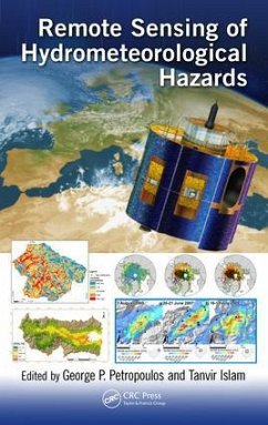
Remote Sensing of Hydrometeorological Hazards
Herausgeber: Petropoulos, George P.; Islam, Tanvir
Remote Sensing of Hydrometeorological Hazards
Herausgeber: Petropoulos, George P.; Islam, Tanvir
- Gebundenes Buch
- Merkliste
- Auf die Merkliste
- Bewerten Bewerten
- Teilen
- Produkt teilen
- Produkterinnerung
- Produkterinnerung
This book focuses on drought, flood, frost, landslides, and storms/cyclones and will cover different applications of EO data used from prediction to mapping damages for each category. It will explain the added value of EO technology in comparison with conventional techniques applied today through many case studies.
Andere Kunden interessierten sich auch für
![Advanced Image Processing Techniques for Remote Sensing Applications Advanced Image Processing Techniques for Remote Sensing Applications]() Kanagala Sateesh KumarAdvanced Image Processing Techniques for Remote Sensing Applications52,99 €
Kanagala Sateesh KumarAdvanced Image Processing Techniques for Remote Sensing Applications52,99 €![SHsearch. A Method for Fast Remote Homology Detection SHsearch. A Method for Fast Remote Homology Detection]() Noha YousriSHsearch. A Method for Fast Remote Homology Detection14,99 €
Noha YousriSHsearch. A Method for Fast Remote Homology Detection14,99 €![Multivariate Proportional Hazards Model Multivariate Proportional Hazards Model]() Sharif MahmoodMultivariate Proportional Hazards Model44,99 €
Sharif MahmoodMultivariate Proportional Hazards Model44,99 €![Extreme Value Theory with Applications to Natural Hazards Extreme Value Theory with Applications to Natural Hazards]() Extreme Value Theory with Applications to Natural Hazards134,99 €
Extreme Value Theory with Applications to Natural Hazards134,99 €![Proactive Remote Healthcare Based on Machine Learning Algorithms Proactive Remote Healthcare Based on Machine Learning Algorithms]() Proactive Remote Healthcare Based on Machine Learning Algorithms38,99 €
Proactive Remote Healthcare Based on Machine Learning Algorithms38,99 €![Extreme Value Theory with Applications to Natural Hazards Extreme Value Theory with Applications to Natural Hazards]() Extreme Value Theory with Applications to Natural Hazards134,99 €
Extreme Value Theory with Applications to Natural Hazards134,99 €![Sparse Modeling Sparse Modeling]() Irina RishSparse Modeling116,99 €
Irina RishSparse Modeling116,99 €-
-
-
This book focuses on drought, flood, frost, landslides, and storms/cyclones and will cover different applications of EO data used from prediction to mapping damages for each category. It will explain the added value of EO technology in comparison with conventional techniques applied today through many case studies.
Hinweis: Dieser Artikel kann nur an eine deutsche Lieferadresse ausgeliefert werden.
Hinweis: Dieser Artikel kann nur an eine deutsche Lieferadresse ausgeliefert werden.
Produktdetails
- Produktdetails
- Verlag: CRC Press
- Seitenzahl: 550
- Erscheinungstermin: 2. November 2017
- Englisch
- Abmessung: 260mm x 183mm x 34mm
- Gewicht: 1217g
- ISBN-13: 9781498777582
- ISBN-10: 1498777589
- Artikelnr.: 57047365
- Herstellerkennzeichnung
- Libri GmbH
- Europaallee 1
- 36244 Bad Hersfeld
- gpsr@libri.de
Dr. George P. Petropoulos is an Associate Professor in Remote Sensing & GIS in the Department of Geography & Earth Sciences (DGES) at Aberystwyth University in Wales, UK. He completed his graduate studies (MSc, PhD) at the University of London. Dr. Petropoulos' research focuses on exploiting EO data alone or synergistically with land surface process models for computing key state variables of the Earth's energy and water budget, including energy fluxes and soil surface moisture. He is also conducting research on the application of remote sensing technology to land cover mapping and its changes occurred from either anthropogenic activities or geohazards (mainly floods, wildfires, frost). Dr. Petropoulos serves as a Council member and Trustee of the Remote Sensing & Photogrammetric Society (RSPSoC), he is Associate Editor and Editorial Board Member on several international peer-reviewed scientific journals in EO and environmental modelling. He has also convened the organisation of several scientific specialised sessions at international conferences. He is Editor/co-editor of 3 other books and co-author +55 peer-reviewed journal articles. He has developed fruitful collaborations with key scientists in his area of specialisation globally, and his research work so far has received international recognition via several noteworthy awards he has obtained. Tanvir Islam is with the NASA Jet Propulsion Laboratory and specializes in remote sensing observations. Presently, he is engaged with the development of advanced microwave calibration and retrieval algorithms for NASA's Earth observing missions. Prior to joining NASA/JPL in 2015, he was with the NOAA/ NESDIS/STAR and worked on the development of satellite remote sensing algorithms, with an emphasis on microwave variational inversion techniques (2013-2015). He also held visiting scientist positions at the University of Tokyo, Japan as part of the NASA/ JAXA precipitation measurement missions (PMM) algorithm development team, in 2012 and at the University of Calgary, Alberta, Canada in 2015. He earned his PhD in remote sensing at the University of Bristol, Bristol, United Kingdom in 2012.
Section I: Remote Sensing of Drought 1. Drought and Remote Sensing: An
Overview 2. Agricultural Drought Monitoring Using Satellite Soil Moisture
and Other Remote Sensing Data over the Iberian Peninsula 3. Drought
Assessments by Coupling Moderate Resolution Imaging Spectroradiometer
Images and Weather Data: A Case Study in the Minas Gerais State, Brazil 4.
The Added Value of Satellite Soil Moisture for Agricultural Index Insurance
5. Detecting the 2012 Drought in the Southeastern United States with
Moderate Resolution Imaging Spectroradiometer- and Gravity Recovery and
Climate Experiment-Based Drought Indicators Section II: Remote Sensing of
Frost and Sea Ice Hazards 6. Frost and Remote Sensing: An Overview of
Capabilities 7. Remote Sensing of Sea Ice Hazards: An Overview 8. Satellite
Microwave Remote Sensing of Landscape Freeze-Thaw Status Related to Frost
Hazard Monitoring 9. Temperature Fluctuation and Frost Risk Analysis on a
Road Network by Coupling Remote Sensing Data, Thermal Mapping, and
Geographic Information System Techniques Section III: Remote Sensing of
Wildfires 10. Wildfires and Remote Sensing: An Overview 11. A Review on
European Remote Sensing Activities in Wildland Fires Prevention 12. Remote
Sensing of Fire Effects: A Review for Recent Advances in Burned Area and
Burn Severity Mapping 13. Exploring the Relationships between Topographical
Elements and Forest Fire Occurrences in Alberta, Canada 14. Quantifying the
Interannual Variability of Wildfire Events across Portugal for the
2014-2015 Wildfires Using the Data from the European Forest Fire
Information System Section IV: Remote Sensing of Flood 15. Satellite Remote
Sensing of Floods for Disaster Response Assistance 16. Usefulness of
Remotely Sensed Data for Extreme Flood Event Modeling: A Study Case from an
Amazonian Floodplain 17. Large-Scale Flood Monitoring in Monsoon Asia for
Global Disaster Risk Reduction Using MODIS/EOS Data 18. Introducing Flood
Susceptibility Index Using Remote-Sensing Data and Geographic Information
Systems: Empirical Analysis in Sperchios River Basin, Greece 19.
Satellite-Based Precipitation for Modeling Floods: Current Status and
Limitations Section V: Remote Sensing of Storms 20. Application of
Remote-Sensing Images for Post-Wind Storm Damage Analysis 21. Analyzing
Tropical Cyclones over India Using Precipitation Radar 22. Radar Rainfall
Estimates for Debris-Flow Early Warning Systems: Effect of Different
Correction Procedures on the Identification of Intensity-Duration
Thresholds Section VI: Remote Sensing of Landslides 23. A Review of
Unmanned Aerial Vehicles, Citizen Science, and Interferometry Remote
Sensing in Landslide Hazards: Applications in Transportation Routes and
Mining Environments 24. Landslide Susceptibility Assessment Mapping: A Case
Study in Central Greece

