Robert Hurst
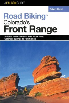
Road Biking¿ Colorado's Front Range
A Guide To The Greatest Bike Rides From Colorado Springs To Fort Collins
16,99 €
inkl. MwSt.
Versandfertig in 1-2 Wochen

8 °P sammeln
Robert Hurst
Road Biking¿ Colorado's Front Range
A Guide To The Greatest Bike Rides From Colorado Springs To Fort Collins
- Broschiertes Buch
- Merkliste
- Auf die Merkliste
- Bewerten Bewerten
- Teilen
- Produkt teilen
- Produkterinnerung
- Produkterinnerung
Detailed descriptions and maps of forty of the best bicycle rides between Fort Collins and Colorado Springs, from easy afternoon jaunts to multi-day tours.
Andere Kunden interessierten sich auch für
![Road Biking¿ North Carolina Road Biking¿ North Carolina]() Judi WallaceRoad Biking¿ North Carolina19,99 €
Judi WallaceRoad Biking¿ North Carolina19,99 €![Road Biking¿ New Mexico Road Biking¿ New Mexico]() Nicole BlouinRoad Biking¿ New Mexico19,99 €
Nicole BlouinRoad Biking¿ New Mexico19,99 €![Road Biking¿ Minnesota Road Biking¿ Minnesota]() Russ LowthianRoad Biking¿ Minnesota20,99 €
Russ LowthianRoad Biking¿ Minnesota20,99 €![Road Biking(TM) New Jersey Road Biking(TM) New Jersey]() Tom HammellRoad Biking(TM) New Jersey17,99 €
Tom HammellRoad Biking(TM) New Jersey17,99 €![Road Biking¿ Northern New England Road Biking¿ Northern New England]() Sandra DulingRoad Biking¿ Northern New England17,99 €
Sandra DulingRoad Biking¿ Northern New England17,99 €![Mountain Biking Denver and Boulder Mountain Biking Denver and Boulder]() Bob D'AntonioMountain Biking Denver and Boulder13,99 €
Bob D'AntonioMountain Biking Denver and Boulder13,99 €![Road Biking¿ Michigan Road Biking¿ Michigan]() Cari NogaRoad Biking¿ Michigan19,99 €
Cari NogaRoad Biking¿ Michigan19,99 €-
-
-
Detailed descriptions and maps of forty of the best bicycle rides between Fort Collins and Colorado Springs, from easy afternoon jaunts to multi-day tours.
Hinweis: Dieser Artikel kann nur an eine deutsche Lieferadresse ausgeliefert werden.
Hinweis: Dieser Artikel kann nur an eine deutsche Lieferadresse ausgeliefert werden.
Produktdetails
- Produktdetails
- Road Biking Series
- Verlag: FALCON GUIDES
- Seitenzahl: 202
- Erscheinungstermin: 1. September 2005
- Englisch
- Abmessung: 229mm x 152mm x 11mm
- Gewicht: 301g
- ISBN-13: 9780762737390
- ISBN-10: 0762737395
- Artikelnr.: 21211278
- Herstellerkennzeichnung
- Books on Demand GmbH
- In de Tarpen 42
- 22848 Norderstedt
- info@bod.de
- 040 53433511
Robert Hurst is a native Coloradan who is just happy to be in one piece after working for ten years as a bike messenger in Denver. He celebrates his continued survival by spending time pedaling his bike nearly seven days a week in Denver during the day and along Colorado's Front Range on the weekends. A 1990 graduate of the University of Colorado, he is the founder of Trails, the insider's source for mountain biking destinations in the Rocky Mountains, and is the author of Mountain Biking Colorado's San Juan Mountains (2001) and The Art of Urban Cycling (2004), both published by Falcon.
Acknowledgments
Introduction
Western Region
1. Horseshoe Harbor
2. Estivant Pines Loop
3. Bare Bluff
4. Black River Waterfalls
5. Presque Isle River Waterfalls Loop
6. Shining Clouds Falls
7. Lake Superior Shoreline
8. Lake Superior/Big Carp River Loop
9. Little Carp River Cascades
10.Mirror Lake Loop
11. Escarpment
12. Union River Cascades Loop
13. Trap Hills Loop
14. Trap Hills Traverse
15. Norwich Bluff
16. Norwich Bluff to Victoria
17. Tibbets Falls/Oren Krumm Shelter
18. Canyon Falls
19. Craig Lake
20. White Deer Lake
21. Falls of the Yellow Dog
22. Little Garlic River
23. Clark Lake Loop
24. Deer Island Lake
25. Piers Gorge
Eastern Region
26. Laughing Whitefish Falls
27. Rock River Falls
28. Grand Island Loop
29. Olson Falls
30. Miner's Falls
31. Pictured Rocks
32. Chapel Loop
33. Beaver Lake Loop
34. Au Sable Point/Logslide
35. Grand Sable Dunes Loop
36. Bruno's Run Loop
37. Seney National Wildlife Refuge
38. Mouth of the Blind Sucker River
39. Two Hearted River
40. Tahquamenon West /NCT
41. Giant Pines Loop
42. Tahquamenon Falls
43. Naomikong Point
44. Cedar River Loop
45. Portage Bay
46. Birch Point
47.Pt. Patterson/Cataract River
48. Maple Hill
49. Horseshoe Bay
50. Marblehead
Appendix A: Hike Finder
ochAppendix B: Useful Addresses for More Information
About The Author
