20,99 €
inkl. MwSt.
Versandfertig in über 4 Wochen

10 °P sammeln
- Broschiertes Buch
- Merkliste
- Auf die Merkliste
- Bewerten Bewerten
- Teilen
- Produkt teilen
- Produkterinnerung
- Produkterinnerung
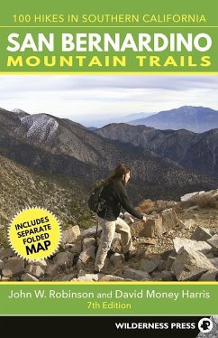
This informative guide details 100 hikes in the San Bernardino National Forest.
Andere Kunden interessierten sich auch für
![Rail-Trails Iowa & Missouri Rail-Trails Iowa & Missouri]() Rails-To-Trails ConservancyRail-Trails Iowa & Missouri16,99 €
Rails-To-Trails ConservancyRail-Trails Iowa & Missouri16,99 €![Oahu Trails Oahu Trails]() Kathy MoreyOahu Trails23,99 €
Kathy MoreyOahu Trails23,99 €![Rail-Trails Pennsylvania Rail-Trails Pennsylvania]() Rails-To-Trails ConservancyRail-Trails Pennsylvania17,99 €
Rails-To-Trails ConservancyRail-Trails Pennsylvania17,99 €![Rail-Trails Michigan & Wisconsin Rail-Trails Michigan & Wisconsin]() Rails-To-Trails ConservancyRail-Trails Michigan & Wisconsin17,99 €
Rails-To-Trails ConservancyRail-Trails Michigan & Wisconsin17,99 €![Peninsula Trails Peninsula Trails]() Jean RusmorePeninsula Trails22,99 €
Jean RusmorePeninsula Trails22,99 €![Rail-Trails Illinois, Indiana, & Ohio Rail-Trails Illinois, Indiana, & Ohio]() Rails-To-Trails ConservancyRail-Trails Illinois, Indiana, & Ohio17,99 €
Rails-To-Trails ConservancyRail-Trails Illinois, Indiana, & Ohio17,99 €![Kauai Trails Kauai Trails]() Kathy MoreyKauai Trails23,99 €
Kathy MoreyKauai Trails23,99 €-
-
-
This informative guide details 100 hikes in the San Bernardino National Forest.
Hinweis: Dieser Artikel kann nur an eine deutsche Lieferadresse ausgeliefert werden.
Hinweis: Dieser Artikel kann nur an eine deutsche Lieferadresse ausgeliefert werden.
Produktdetails
- Produktdetails
- Verlag: Wilderness Press
- 7th edition
- Seitenzahl: 288
- Erscheinungstermin: 18. Oktober 2016
- Englisch
- Abmessung: 213mm x 140mm x 20mm
- Gewicht: 386g
- ISBN-13: 9780899978079
- ISBN-10: 089997807X
- Artikelnr.: 44533930
- Herstellerkennzeichnung
- Produktsicherheitsverantwortliche/r
- Europaallee 1
- 36244 Bad Hersfeld
- gpsr@libri.de
JOHN W. ROBINSON has been exploring, backpacking, and climbing throughout the Mountain West, from Alaska and Canada to Mexico, for more than 50 years. His first guide, Camping and Climbing in Baja (now out of print), set the standard for guides to the Baja California mountains. His Trails of the Angeles, now in its eighth edition, remains the definitive hiking guide to Southern California's San Gabriel Mountains. He has authored or coauthored a number of the original Wilderness Press quadrangle guides, covering California's three major southern ranges: the San Gabriels, the San Bernardinos, and the San Jacintos. In addition, he has published numerous articles in Westways, Desert Magazine, Southern California Quarterly, Overland Journal, and Summit. If the mines of Southern California's mountains revealed gold and other precious minerals, they cannot compare to the treasure trove of information contained in this one man. His love for these forests, peaks, and wilderness areas is apparent on every page of his many works. DAVID MONEY HARRIS is a professor of engineering at Harvey Mudd College. He is the author or coauthor of six hiking guidebooks and five engineering textbooks. David grew up rambling around the Desolation Wilderness as a toddler in his father's pack and later roamed the High Sierra as a Boy Scout. As a Sierra Club trip leader, he organized mountaineering trips throughout the Sierra Nevada. Since 1999, he has been exploring the mountains and deserts of Southern California. He lives with his wife and three sons in Upland, California, and delights in sharing his love of the outdoors with their boys.
PART ONE: THE SAN BERNARDINO MOUNTAINS
1. Pacific Crest Trail to San Andreas Rift Viewpoint
2. Cajon Mountain
3. Heart Rock
4. Deep Creek Hot Springs from Bowen Ranch
5. Deep Creek Hot Springs from Kinley Creek
6. The Pinnacles
7. Metate Trail
8. Tunnel Two Trail
9. Little Bear Creek
10. Deep Creek
11. Holcomb Creek
12. Heaps Peak Arboretum
13. Upper Deep Creek
14. Holcomb Crossing Trail Camp
15. Shay Mountain
16. Cox Creek
17. Exploration Trail
18. Little Green Valley
19. Siberia Creek Trail Camp from Snow Valley
20. Grays Peak
21. Delamar Mountain
22. Bertha Peak
23. Gold Mountain
24. Silver Peak
25. Whitewater Canyon View Loop
26. Castle Rock
27. Champion Lodgepole Pine
28. Siberia Creek
29. Grand View Point
30. Skyline Trail
31. Sugarloaf Mountain from Green Canyon
32. Sugarloaf Mountain from Wildhorse Meadows
33. Wildhorse Creek
34. Santa Ana River Headwaters
35. Fish Creek Meadow
36. Fish Creek
37. Ponderosa Nature Trail
38. Siberia Creek Trail Camp from Seven Pines
39. South Fork Meadows
40. Dollar Lake
41. Dry Lake
42. San Gorgonio Mountain via Dollar Lake Saddle
43. San Gorgonio Mountain via Mine Shaft Saddle
44. North Fork Meadows
45. Johns Meadow
46. San Bernardino Peak Divide from Forsee Creek
47. San Bernardino Peak
48. The Great San Bernardino Divide
49. Mountain Home Flats
50. San Bernardino Peak Divide from Mill Creek
51. Alger Creek Trail Camp
52. Dollar Lake Saddle from Mill Creek
53. Big Falls
54. San Gorgonio Mountain via Vivian Creek
55. Galena Peak
PART TWO: THE SAN JACINTO MOUNTAINS
56. Black Mountain
57. San Jacinto Peak via Fuller Ridge Trail
58. Indian Mountain
59. North Fork San Jacinto River
60. Seven Pines Trail
61. San Jacinto Peak via Marion Mountain Trail
62. Webster Trail
63. Suicide Rock
64. Strawberry-Saddle Loop
65. San Jacinto Peak from Idyllwild
66. Skunk Cabbage Meadow
67. San Jacinto Peak from Humber Park
68. Jean Peak and Marion Mountain
69. Humber Park-Round Valley Loop
70. Tahquitz Valley
71. Caramba
72. Tahquitz Peak via Saddle Junction
73. Lily Rock
74. Desert Divide
75. Ernie Maxwell Scenic Trail
76. Tahquitz Peak via South Ridge Trail
77. Antsell Rock
78. Apache Peak
79. Palm View Peak
80. Cedar Spring
81. Thomas Mountain
82. Cahuilla Mountain
83. Long, Round, and Tamarack Valleys
84. San Jacinto Peak from the Tramway
85. Lykken Loop
86. San Jacinto via Skyline Trail
87. Murray Canyon
88. Lower Palm Canyon
89. Fern Canyon Loop
90. Jo Pond Trail
91. Palm Canyon Traverse
92. Pinyon Trail
93. Desert Divide and Palm Canyon
PART THREE: THE SANTA ROSA MOUNTAINS
94. Alta Seca Bench
95. Horsethief Creek
96. Cactus Spring Trail
97. Sawmill Trail
98. Rabbit Peak from Coachella Valley
99. Villager and Rabbit Peaks
100. Old Santa Rosa
