192,99 €
inkl. MwSt.
Versandkostenfrei*
Versandfertig in über 4 Wochen
payback
96 °P sammeln
  • Gebundenes Buch

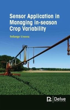
It is essential to produce climate system models that can bring about an accurate representation of the climate forecast. The concept of global warming has become a local phrase for every region and its effects are obvious on the farming communities. The models generated can be used to project the current situations and can help us predict or forecast the potential perils in the future. In this book, the sensor applications are explained with respect to the agricultural sectors. Remote sensing and GIS are considered as important tools in mapping agricultural fields and their associated…mehr

Produktbeschreibung
It is essential to produce climate system models that can bring about an accurate representation of the climate forecast. The concept of global warming has become a local phrase for every region and its effects are obvious on the farming communities. The models generated can be used to project the current situations and can help us predict or forecast the potential perils in the future. In this book, the sensor applications are explained with respect to the agricultural sectors. Remote sensing and GIS are considered as important tools in mapping agricultural fields and their associated factors. The mapping of crops with several space-borne platforms and airborne platforms is explained. This book can be used as a handbook for engineers, scientists and research scholars along with undergraduates and postgraduates in science and technology.
Hinweis: Dieser Artikel kann nur an eine deutsche Lieferadresse ausgeliefert werden.
Autorenporträt
Solange Uwera is a GIS and Remote Sensing Expert. She received her Master's degrees in Geographical Information Science from the University of Manchester and in Human Settlement and Urbanism from the University of Leuven and a bachelor's degree in Biodiversity Conservation from the National University of Rwanda. Solange works on various development and humanitarian projects at United Nations Satellite Centre. She worked in Geneva, Brussels, Rwanda and Madagascar where she applied geospatial technology for humanitarian, development and environmental applications.