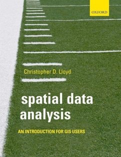
Christopher Lloyd (Archaeology School of Geography and Palaeoecolo
Spatial Data Analysis
An Introduction for GIS users
Christopher Lloyd (Archaeology School of Geography and Palaeoecolo
Spatial Data Analysis
An Introduction for GIS users
- Broschiertes Buch
- Merkliste
- Auf die Merkliste
- Bewerten Bewerten
- Teilen
- Produkt teilen
- Produkterinnerung
- Produkterinnerung
Spatial Data Analysis introduces key principles about spatial data and provides guidance on methods for their exploration; it provides a set of key ideas or frameworks that will give the reader knowledge of the kinds of problems that can be tackled using the tools that are widely available for the analysis of spatial data.
Andere Kunden interessierten sich auch für
![Statistical Methods for Spatial Data Analysis Statistical Methods for Spatial Data Analysis]() Oliver SchabenbergerStatistical Methods for Spatial Data Analysis47,99 €
Oliver SchabenbergerStatistical Methods for Spatial Data Analysis47,99 €![Geographic Information Systems to Spatial Data Infrastructures Geographic Information Systems to Spatial Data Infrastructures]() Geographic Information Systems to Spatial Data Infrastructures47,99 €
Geographic Information Systems to Spatial Data Infrastructures47,99 €![Spatial Data Science Spatial Data Science]() Dr. John P. WilsonSpatial Data Science71,99 €
Dr. John P. WilsonSpatial Data Science71,99 €![Spatial Statistics Illustrated Spatial Statistics Illustrated]() Lauren BennettSpatial Statistics Illustrated46,99 €
Lauren BennettSpatial Statistics Illustrated46,99 €![Introduction to Environmental Data Science Introduction to Environmental Data Science]() William W. Hsieh (Vancouver University of British Columbia)Introduction to Environmental Data Science84,99 €
William W. Hsieh (Vancouver University of British Columbia)Introduction to Environmental Data Science84,99 €![Satellite Interferometry Data Interpretation and Exploitation Satellite Interferometry Data Interpretation and Exploitation]() Michele Crosetto (Head, Geomatics Division, Centre Tecnologic de TeSatellite Interferometry Data Interpretation and Exploitation174,99 €
Michele Crosetto (Head, Geomatics Division, Centre Tecnologic de TeSatellite Interferometry Data Interpretation and Exploitation174,99 €![Principles of Geographical Information Systems Principles of Geographical Information Systems]() Professor Peter A. Burrough (Former Professor of Physical GeographyPrinciples of Geographical Information Systems77,99 €
Professor Peter A. Burrough (Former Professor of Physical GeographyPrinciples of Geographical Information Systems77,99 €-
-
-
Spatial Data Analysis introduces key principles about spatial data and provides guidance on methods for their exploration; it provides a set of key ideas or frameworks that will give the reader knowledge of the kinds of problems that can be tackled using the tools that are widely available for the analysis of spatial data.
Hinweis: Dieser Artikel kann nur an eine deutsche Lieferadresse ausgeliefert werden.
Hinweis: Dieser Artikel kann nur an eine deutsche Lieferadresse ausgeliefert werden.
Produktdetails
- Produktdetails
- Verlag: Oxford University Press
- Seitenzahl: 224
- Erscheinungstermin: 3. Dezember 2009
- Englisch
- Abmessung: 246mm x 190mm x 19mm
- Gewicht: 452g
- ISBN-13: 9780199554324
- ISBN-10: 0199554323
- Artikelnr.: 29425037
- Herstellerkennzeichnung
- Libri GmbH
- Europaallee 1
- 36244 Bad Hersfeld
- gpsr@libri.de
Chris Lloyd is a Lecturer in Geography (GIS) in the School of Geography, Archaeology, and Paleoecology at Queen's University, Belfast.
* Chapter 1. Introduction
* 1.1: Spatial data analysis
* 1.2: Purpose of the book
* 1.3: Key concepts
* 1.4: Structure of the book
* 1.5: Further reading
* Chapter 2. Key concepts 1: GIS
* 2.1: Introduction
* 2.1: Data and data models
* 2.2.1: Raster data
* 2.2.2: Vector data
* 2.2.3: Topology
* 2.2.4: Rasters and vectors in GIS software
* 2.3: Databases
* 2.3.1: Database management
* 2.3.2: The Geodatabase
* 2.4: Referencing systems and projections
* 2.5: Georeferencing
* 2.6: Geocoding
* 2.7: Spatial scale
* 2.8: Spatial data collection
* 2.8.1: Spatial sampling
* 2.8.2: Secondary data analysis
* 2.8.3: Remote sensing
* 2.8.4: Ground survey
* 2.9: Sources of data error
* 2.9.1: Uncertainty in spatial data analysis
* 2.10: Visualising spatial data
* 2.11: Querying data
* 2.11.1: Boolean logic
* 2.12: Summary
* 2.13: Further reading
* Chapter 3. Key concepts 2: statistics
* 3.1: Introduction
* 3.2: Univariate statistics
* 3.3: Multivariate statistics
* 3.4: Inferential statistics
* 3.5: Statistics and spatial data
* 3.6: Summary
* 3.7: Further reading
* Chapter 4. Key concepts 3: spatial data analysis
* 4.1: Introduction
* 4.2: Distances
* 4.3: Measuring lengths and perimeters
* 4.3.1: Length of vector features
* 4.4: Measuring areas
* 4.4.1: Areas of polygons
* 4.5: Distances from objects: buffers
* 4.5.1: Vector buffers
* 4.5.2: Raster proximity
* 4.6: Moving windows: basic statistics in sub-regions
* 4.7: Geographical weights
* 4.8: Spatial dependence and spatial autocorrelation
* 4.9: The ecological fallacy and the modifiable areal unit problem
* 4.10: Merging polygons
* 4.11: Summary
* 4.12: Further reading
* Chapter 5. Combining data layers
* 5.1: Introduction
* 5.2: Multiple features: overlays
* 5.2.1: Point in polygon
* 5.2.2: Overlay operators
* 5.2.3: 'Cookie cutter' operations: erase and clip
* 5.2.4: Applications and problems
* 5.3: Multicriteria decision analysis
* 5.4: Case study
* 5.5: Summary
* 5.6: Further reading
* Chapter 6. Network analysis
* 6.1: Introduction
* 6.2: Networks
* 6.3: Network connectivity
* 6.4: Summaries of network characteristics
* 6.5: Identifying shortest paths
* 6.6: The travelling salesperson problem
* 6.7: Location-allocation problems
* 6.8: Case study
* 6.9: Summary
* 6.10: Further reading
* Chapter 7. Exploring spatial point patterns
* 7.1: Introduction
* 7.2: Basic measures
* 7.3: Exploring spatial variations in point intensity
* 7.3.1: Quadrats
* 7.3.2: Kernel estimation
* 7.4: measures based on distances between events
* 7.4.1: Nearest neighbour methods
* 7.4.2: K function
* 7.5: Applications and other issues
* 7.6: Case study
* 7.7: Summary
* 7.8: Further reading
* Chapter 8. Exploring spatial patterning in data values
* 8.1: Introduction
* 8.2: Spatial autocorrelation
* 8.3: Local statistics
* 8.4: Local univariate measures
* 8.4.1: Local spatial autocorrelation
* 8.5: Regression and correlation
* 8.5.1: Spatial regression
* 8.5.2: Moving window regression (MWR)
* 8.5.3: Geographically weighted regression (GWR)
* 8.6: Other approaches
* 8.7: Case studies
* 8.7.1: Spatial autocorrelation analysis
* 8.7.2: GWR
* 8.8: Summary
* 8.9: Further reading
* Chapter 9. Spatial interpolation
* 9.1: Introduction
* 9.2: Interpolation
* 9.3: Triangulated irregular networks
* 9.4: Regression for prediction
* 9.4.1: Trend surface analysis
* 9.5: Inverse distance weighting
* 9.6: Thin plate splines
* 9.7: Ordinary kriging
* 9.7.1: Variogram
* 9.7.2: Kriging
* 9.7.3: Cokriging
* 9.8: Other approaches and other issues
* 9.9: Areal interpolation
* 9.10: Case studies
* 9.10.1: Variogram estimation
* 9.10.2: Spatial interpolation
* 9.11: Summary
* 9.12: Further reading
* Chapter 10. Analysis of grids and surfaces
* 10.1: Introduction
* 10.2: Map algebra
* 10.3: Image processing
* 10.4: Spatial filters
* 10.5: Derivatives of altitude
* 10.6: Other products derived from surfaces
* 10.7: Case study
* 10.8: Summary
* 10.9: Further reading
* Chapter 11. Summary
* 11.1: Review of key concepts
* 11.2: Other issues
* 11.3: Problems
* 11.4: Where next?
* 11.5: Summary and conclusions
* References
* Appendix A. Matrix multiplication
* Appendix B. The exponential function
* Appendix C. The inverse tangent Appendix D. Line Intersection
Appendix E. Ordinary least squares Appendix F. Ordinary kriging
system Appendix G. Problems and solutions

