- Broschiertes Buch
- Merkliste
- Auf die Merkliste
- Bewerten Bewerten
- Teilen
- Produkt teilen
- Produkterinnerung
- Produkterinnerung
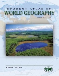
The Student Atlas series combines full-color maps and data sets to introduce students to the importance of the connections between geography and other areas of study such as world politics, environmental issues, and economic development. These thematic atlases will give students a clear picture of the recent agricultural, industrial, demographic, environmental, economic, and political changes in every world region.
Andere Kunden interessierten sich auch für
![Rand McNally Geography & Maps Activities, Intermediate Ages 9+ Rand McNally Geography & Maps Activities, Intermediate Ages 9+]() Rand McnallyRand McNally Geography & Maps Activities, Intermediate Ages 9+10,99 €
Rand McnallyRand McNally Geography & Maps Activities, Intermediate Ages 9+10,99 €![Delorme Atlas & Gazetteer: Alaska Delorme Atlas & Gazetteer: Alaska]() Rand McnallyDelorme Atlas & Gazetteer: Alaska27,99 €
Rand McnallyDelorme Atlas & Gazetteer: Alaska27,99 €![Atlas of Hispanic-American History Atlas of Hispanic-American History]() George OchoaAtlas of Hispanic-American History21,99 €
George OchoaAtlas of Hispanic-American History21,99 €![Cram's Quick Reference Atlas and Gazetteer of the World Cram's Quick Reference Atlas and Gazetteer of the World]() George Franklin CramCram's Quick Reference Atlas and Gazetteer of the World38,99 €
George Franklin CramCram's Quick Reference Atlas and Gazetteer of the World38,99 €![Compact World Atlas Compact World Atlas]() DkCompact World Atlas14,99 €
DkCompact World Atlas14,99 €![Greater Yellowstone & Grand Teton Recreation Atlas Greater Yellowstone & Grand Teton Recreation Atlas]() Greater Yellowstone & Grand Teton Recreation Atlas18,99 €
Greater Yellowstone & Grand Teton Recreation Atlas18,99 €![Dartford & Gravesend A-Z Street Atlas Dartford & Gravesend A-Z Street Atlas]() Geographers' A-Z Map Co LtdDartford & Gravesend A-Z Street Atlas9,99 €
Geographers' A-Z Map Co LtdDartford & Gravesend A-Z Street Atlas9,99 €-
-
-
The Student Atlas series combines full-color maps and data sets to introduce students to the importance of the connections between geography and other areas of study such as world politics, environmental issues, and economic development. These thematic atlases will give students a clear picture of the recent agricultural, industrial, demographic, environmental, economic, and political changes in every world region.
Hinweis: Dieser Artikel kann nur an eine deutsche Lieferadresse ausgeliefert werden.
Hinweis: Dieser Artikel kann nur an eine deutsche Lieferadresse ausgeliefert werden.
Produktdetails
- Produktdetails
- Student Atlas
- Verlag: McGraw Hill LLC
- Seitenzahl: 319
- Erscheinungstermin: März 2009
- Englisch
- Abmessung: 272mm x 213mm x 15mm
- Gewicht: 907g
- ISBN-13: 9780073527604
- ISBN-10: 0073527602
- Artikelnr.: 25446210
- Herstellerkennzeichnung
- Produktsicherheitsverantwortliche/r
- Europaallee 1
- 36244 Bad Hersfeld
- gpsr@libri.de
McGraw-Hill authors represent the leading experts in their fields and are dedicated to improving the lives, careers, and interests of readers worldwide
A Note to the Student_iii
Introduction: How to Read an Atlas_xi
Map 1_World Political Divisions_2
Map 2_World Physical Features_4
Map 3a_Average Annual Precipitation_6
Map 3b_Seasonal Average Precipitation, November through April_7
Map 3c_Seasonal Average Precipitation, May through October_7
Map 3d_Variation in Average Annual Precipitation_8
Map 4a_Temperature Regions and Ocean Currents_9
Map 4b_Average January Temperature_10
Map 4c_Average July Temperature_10
Map 5a_Atmospheric Pressure and Predominant Surface Winds, January_11
Map 5b_Atmospheric Pressure and Predominant Surface Winds, July_12
Map 6_Climate Regions_13
Map 7_Vegetation Types_14
Map 8_Soil Orders_15
Map 9_Ecological Regions_16
Map 10_Plate Tectonics_18
Map 11_Topography_19
Map 12a_Resources: Mineral Fuels_20
Map 12b_Resources: Critical Metals_21
Map 13_Natural Hazards_22
Map 14_Past Population Distributions and Densities_24
Map 15_Population Density_26
Map 16_Land Use, A.D. 1500_27
Map 17_Economic Activities_28
Map 18_Urbanization_29
Map 19_Transportation Patterns_30
Map 20_Religions_31
Map 21_Religious Adherence_32
Map 22_Languages_33
Map 23_Linguistic Diversity_34
Map 24_Dying Languages: A Loss of Cultural Wealth_35
Map 25_External Migrations in Modern Times_36
Map 26_Population Growth Rates_38
Map 27_Europe's Population Bust: A Fizzle in the Population Bomb_39
Map 28a_Total Fertility Rates_40
Map 28b_Total Fertility Rates_41
Map 29_Infant Mortality Rate_42
Map 30_Child Mortality Rate_43
Map 31_Child Malnutrition_44
Map 32_Primary School Enrollment_45
Map 33_Average Life Expectancy at Birth_46
Map 34_Population by Age Group_47
Map 35_International Migrant Populations 2005_48
Map 36_World Daily Per Capita Food Supply (Kilocalories)_49
Map 37_The Earth's Hungry Millions_50
Map 38_Proportion of Daily Food Intake from Animal Products_51
Map 39_Illiteracy Rates_52
Map 40_Female/Male Inequality in Education and Employment_53
Map 41_The Global Security Threat of Infectious Diseases _54
Map 42_Global Scourges: Major Infectious Diseases _56
Map 43_Adult HIV Prevalence 2005_57
Map 44_The Index of Human Development_58
Map 45_Demographic Stress: The Youth Bulge_59
Map 46_Demographic Stress: Rapid Urban Growth_60
Map 47_Demographic Stress: Competition for Cropland_61
Map 48_Demographic Stress: Competition for Fresh Water_62
Map 49_Demographic Stress: Death in the Prime of Life_63
Map 50_Demographic Stress: Interactions of Demographic Stress Factors_64
Map 51_Rich and Poor Countries: Gross National Income_66
Map 52_Gross National Income Per Capita_67
Map 53_Economic Growth: GDP Change Per Capita_68
Map 54_Total Labor Force_69
Map 55_Employment by Economic Activity_70
Map 56_Economic Output Per Sector_71
Map 57_Agricultural Production Per Capita_72
Map 58_Exports of Primary Products_73
Map 59_Dependence on Trade_74
Map 60_The Indebtedness of States_75
Map 61_Global Flows of Investment Capital_76
Map 62_Central Government Expenditures Per Capita_77
Map 63_Purchasing Power Parity Per Capita_78
Map 64_Private Per Capita Consumption 2008_79
Map 65_Energy Production Per Capita_80
Map 66_Energy Consumption Per Capita_81
Map 67_Energy Dependency_82
Map 68_Flows of Oil_83
Map 69_The Cost of Consumption 2008_84
Map 70_A Wired World: Internet Users_85
Map 71_The Rise of the Personal Computer_86
Map 72_Traditional Links: The Telephone_87
Map 73_Global Air Pollution: Sources and Wind Currents_91
Map 74_The Acid Deposition Problem: Air, Water, Soil_92
Map 75_Major Polluters and Common Pollutants_93
Map 76_Global Carbon Dioxide Emissions_94
Map 77_The Earth Warms: 1976-2006_95
Map 78_Global Precipitation Changes: 1976-2006_96
Map 79_Potential Global Temperature Change_97
Map 80_Water Resources: Availability of Renewable Water Per Capita_98
Map 81_Water Resources: Annual Withdrawal Per Capita_99
Map 82_Water Stress: Shortage, Abundance, and Population Density_100
Map 83_A New Environmental Stress? Consumption of Bottled Water_101
Map 84_Pollution of the Oceans_102
Map 85_Food Supply from Marine and Freshwater Systems_103
Map 86_Cropland Per Capita: Changes 1996-2007_104
Map 87_Food Staples Under Stress: The Fight Against Genetic Simplicity_105
Map 88_The Rise in Organic Farming_106
Map 89_World Pastureland 2005_107
Map 90_Fertilizer Use 2007_108
Map 91_Annual Deforestation Rates 2000-2005_109
Map 92_World Timber Production 2005_110
Map 93_The Loss of Biodiversity: Globally Threatened Animal Species
2007_111
Map 94_Disappearing Giants: The Reduction in "Conservative" Species_112
Map 95_The Loss of Biodiversity: Globally Threatened Plant Species 2007_114
Map 96_The Areas of Greatest Loss and Hotspots of Biodiversity_115
Map 97_Nationally Protected Areas: Parks and Preserves_116
Map 98_The Risks of Desertification_117
Map 99_Global Soil Degradation_118
Map 100_The Degree of Human Disturbance_119
Map 101_The Green and Not So Green World_120
Map 102_Political Systems_122
Map 103_Sovereign States: Duration of Independence_123
Map 104_The Emergence of the State_124
Map 105_Organized States and Chiefdoms, A.D. 1500_126
Map 106_European Colonialism 1500-2000_128
Map 107_Post-Cold War International Alliances_129
Map 108_International Conflicts in the Post-World War II World_130
Map 109_Political Realms: Regional Changes, 1945-2003_132
Map 110_The Geopolitical World at the Beginning of the Twenty-First
Century_133
Map 111_Democracy on the Rise_134
Map 112_Flashpoints, 2008_135
Map 113_Nations with Nuclear Weapons_150
Map 114_Military Power_151
Map 115_International Terrorist Incidents, 2000-2006_152
Map 116_Distribution of Minority Populations_154
Map 117_Marginalized Minorities: Declining Indigenous Populations_155
Map 118_The Political Geography of a Global Religion: The Islamic World_156
Map 119_World Refugee Population_157
Map 120_Women's Rights_158
Map 121_Political and Civil Liberties, 2008_159
Map 122_Abuse of Public Trust_160
Map 123_The Perception of Corruption_161
Map 124_A Decade of Risk of Civil Conflict, 2005-2015_162
Map 125_North America: Political Divisions_165
Map 126_North America: Physical Features_166
Map 127_North America: Thematic
Map 127a_Environment and Economy: The Use of Land_167
Map 127b_Population Density_168
Map 127c_Population Distribution: Clustering_168
Map 127d_Deforestation in North and Middle America_169
Map 128_Canada_170
Map 129_United States_171
Map 130_Middle America_172
Map 131_The Caribbean_173
Map 132_South America: Political Divisions_174
Map 133_South America: Physical Features_175
Map 134_South America: Thematic
Map 134a_Environment and Economy_176
Map 134b_Population Density_177
Map 134c_Environmental Problems_177
Map 134d_Protection of Natural Areas_178
Map 135_Northern South America_179
Map 136_Southern South America_180
Map 137_Europe: Political Divisions_181
Map 138_Europe: Physical Features_182
Map 139_Europe: Thematic
Map 139a_Environment and Economy: The Use of Land_183
Map 139b_Population Density_184
Map 139c_European Political Boundaries, 1914-1948_185
Map 139d_Political Changes, 1989-2008_187
Map 140_Western Europe_188
Map 141_Eastern Europe_189
Map 142_Northern Europe_190
Map 143_Africa: Political Divisions_191
Map 144_Africa: Physical Features_192
Map 145_Africa: Thematic
Map 145a_Environment and Economy_193
Map 145b_Population Density_193
Map 145c_Colonial Patterns_194
Map 145d_African Cropland and Dryland Degradation_195
Map 146_Northern Africa_196
Map 147_Southern Africa_197
Map 148_Asia: Political Divisions_198
Map 149_Asia: Physical Features_199
Map 150_Asia: Thematic
Map 150a_Environment and Economy_200
Map 150b_Population Density_201
Map 150c_Industrialization: Manufacturing and Resources_201
Map 150d_South, Southeast, and East Asian Deforestation_202
Map 151_Northern Asia_203
Map 152_Southwestern Asia_204
Map 152a_The Middle East: Territorial Changes, 1918-2004_205
Map 152b_South-Central Eurasia: An Ethnolinguistic Crazy Quilt_206
Map 153_East Asia_207
Map 154_Southeast Asia_208
Map 155_Australasia and Oceania: Political Divisions_209
Map 156_Australasia and Oceania: Physical Features_210
Map 157_Australasia: Thematic
Map 157a_Environment and Economy_211
Map 157b_Population Density_212
Map 157c_Climatic Patterns_212
Map 158_The Pacific Rim_213
Map 159_The Atlantic Ocean_214
Map 160_The Indian Ocean_215
Map 161_The Arctic_216
Map 162_Antarctica_216
Table A_World Countries: Area, Population, and Population Density, 2008_218
Table B_World Countries: Form of Government, Capital City, Ma jor
Languages_223
Table C_World Countries: Basic Economic Indicators_228
Table D_World Countries: Population Growth, 1950-2025_233
Table E_World Countries: Basic Demographic Data, 1990-2006_237
Table F_World Countries: Mortality, Health, and Nutrition, 1990-2006_243
Table G_World Countries: Education and Literacy, 2003-2007_250
Table H_World Countries: Agricultural Operations, 2003-2006_260
Table I_World Countries: Deforestation and Biodiversity, 1990-2007_266
Table J_World Countries: Energy Production and Use, 1990-2005_271
Table K_World Countries: Energy Efficiency and Emission, 1990-2005_275
Table L_World Countries: Power and Transportation, 1990-2006_281
Table M_World Countries: Communication, Information, and Science and
Technology, 2004-2006_286
Table N_World Countries: Freshwater Resources_296

