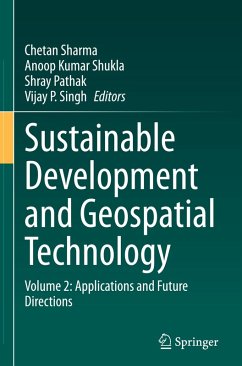
Sustainable Development and Geospatial Technology
Volume 2: Applications and Future Directions
Herausgegeben:Sharma, Chetan; Shukla, Anoop Kumar; Pathak, Shray; Singh, Vijay P.
Sustainable Development and Geospatial Technology
Volume 2: Applications and Future Directions
Herausgegeben:Sharma, Chetan; Shukla, Anoop Kumar; Pathak, Shray; Singh, Vijay P.
- Gebundenes Buch
- Merkliste
- Auf die Merkliste
- Bewerten Bewerten
- Teilen
- Produkt teilen
- Produkterinnerung
- Produkterinnerung
This two-volume set showcases the various ways in which geospatial technology can be used to achieve sustainable development goals across different sectors such as urban planning, natural resource management, agriculture, disaster management, and energy management. The books provide insights into the potential of geospatial technology in promoting sustainable development practices and addressing challenges related to climate change, environmental degradation, and socio-economic development. Both volumes together are a comprehensive guide that showcases the potential of geospatial technology in…mehr
Andere Kunden interessierten sich auch für
![Sustainable Development and Geospatial Technology Sustainable Development and Geospatial Technology]() Sustainable Development and Geospatial Technology154,99 €
Sustainable Development and Geospatial Technology154,99 €![Earth Observations and Geospatial Science in Service of Sustainable Development Goals Earth Observations and Geospatial Science in Service of Sustainable Development Goals]() Earth Observations and Geospatial Science in Service of Sustainable Development Goals116,99 €
Earth Observations and Geospatial Science in Service of Sustainable Development Goals116,99 €![Geographic Information Geographic Information]() Wade BishopGeographic Information116,99 €
Wade BishopGeographic Information116,99 €![Mapping and Spatial Analysis of Socio-economic and Environmental Indicators for Sustainable Development Mapping and Spatial Analysis of Socio-economic and Environmental Indicators for Sustainable Development]() Mapping and Spatial Analysis of Socio-economic and Environmental Indicators for Sustainable Development77,99 €
Mapping and Spatial Analysis of Socio-economic and Environmental Indicators for Sustainable Development77,99 €![Mapping and Spatial Analysis of Socio-economic and Environmental Indicators for Sustainable Development Mapping and Spatial Analysis of Socio-economic and Environmental Indicators for Sustainable Development]() Mapping and Spatial Analysis of Socio-economic and Environmental Indicators for Sustainable Development77,99 €
Mapping and Spatial Analysis of Socio-economic and Environmental Indicators for Sustainable Development77,99 €![Geospatial Technology for Human Well-Being and Health Geospatial Technology for Human Well-Being and Health]() Geospatial Technology for Human Well-Being and Health131,99 €
Geospatial Technology for Human Well-Being and Health131,99 €![Geospatial Technology for Human Well-Being and Health Geospatial Technology for Human Well-Being and Health]() Geospatial Technology for Human Well-Being and Health131,99 €
Geospatial Technology for Human Well-Being and Health131,99 €-
-
-
This two-volume set showcases the various ways in which geospatial technology can be used to achieve sustainable development goals across different sectors such as urban planning, natural resource management, agriculture, disaster management, and energy management. The books provide insights into the potential of geospatial technology in promoting sustainable development practices and addressing challenges related to climate change, environmental degradation, and socio-economic development. Both volumes together are a comprehensive guide that showcases the potential of geospatial technology in promoting sustainable development practices across different sectors, and will serve as an essential resource for professionals, policymakers, researchers, and students interested in sustainable development and geospatial technology.
Volume 2 explores practical applications, insightful case studies, and emerging trends within the dynamic intersection of sustainable development and geospatial technology. Delving into the critical domain of water resources and agriculture, it scrutinizes the application of geospatial tools in river basin management, integrated water resources management (IWRM), sustainable agriculture, and precision agriculture. The volume then shifts its focus to disaster management, energy, and the future, encompassing geospatial data science for disaster resilience, Earth observation for sustainable energy management, and diverse case studies that highlight the impact of geospatial technology on sustainable development. Moreover, it ventures into environmental monitoring and analysis, discussing topics like land use planning, climate change mitigation, environmental monitoring technology, and socioeconomic inequalities.
Volume 2 explores practical applications, insightful case studies, and emerging trends within the dynamic intersection of sustainable development and geospatial technology. Delving into the critical domain of water resources and agriculture, it scrutinizes the application of geospatial tools in river basin management, integrated water resources management (IWRM), sustainable agriculture, and precision agriculture. The volume then shifts its focus to disaster management, energy, and the future, encompassing geospatial data science for disaster resilience, Earth observation for sustainable energy management, and diverse case studies that highlight the impact of geospatial technology on sustainable development. Moreover, it ventures into environmental monitoring and analysis, discussing topics like land use planning, climate change mitigation, environmental monitoring technology, and socioeconomic inequalities.
Produktdetails
- Produktdetails
- Verlag: Springer / Springer Nature Switzerland / Springer, Berlin
- Artikelnr. des Verlages: 978-3-031-65702-3
- 2024
- Seitenzahl: 284
- Erscheinungstermin: 27. September 2024
- Englisch
- Abmessung: 241mm x 160mm x 20mm
- Gewicht: 589g
- ISBN-13: 9783031657023
- ISBN-10: 3031657020
- Artikelnr.: 70920079
- Herstellerkennzeichnung Die Herstellerinformationen sind derzeit nicht verfügbar.
Dr Chetan Sharma Dr. Chetan Sharma is a seasoned academician, researcher, and industry professional with over a decade of experience in civil and environmental engineering. Presently, working as Postdoctoral fellow at the University of Texas at San Antonio (UTSA), Dr. Sharma has continued to expand his research portfolio, focusing on AI modeling of complex karst aquifer systems and the impact of climate change on water availability. Holding a Ph.D. from the prestigious Indian Institute of Technology, Roorkee, Dr. Sharma's expertise lies in climate change impact assessment, artificial intelligence, machine learning models, stochastic hydrology, and sustainability measures. Dr. Sharma's commitment to research excellence is evident in his publication record, with the articles published in high-impact peer-reviewed journals, book chapters, and conference publications. He is also review editor for Frontiers in Climate research journal. He has reviewed more than 20 research articles, conference papers and book chapters. His research has garnered recognition from the scientific community, as reflected in his citation metrics and invitations to present his work at international conferences and symposiums. In addition to his academic pursuits, Dr. Sharma has actively engaged in industry collaborations and consultancy projects, bridging the gap between academia and real-world applications. Beyond his research endeavors, Dr. Sharma is deeply committed to fostering the next generation of engineering professionals. He has served as a mentor and supervisor to numerous undergraduate and graduate students, guiding them in research projects and providing valuable insights into the field of civil and environmental engineering. Dr. Sharma's leadership qualities and collaborative spirit have also been recognized in various academic and professional settings. He has held positions of responsibility as the Head of Department at leading engineering institutions in India, where he played a pivotal role in curriculum development, faculty coordination, and student mentoring. In his pursuit of academic excellence, Dr. Sharma remains dedicated to lifelong learning and professional development. He actively participates in conferences, workshops, and training programs to stay abreast of the latest advancements in his field and to network with fellow researchers and practitioners. Dr Anoop Kumar Shukla Dr. Anoop Kumar Shukla is an Assistant Professor at Manipal School of Architecture and Planning (MSAP), Manipal Academy of Higher Education, Manipal, Karnataka, India. He holds eight years of research experience in Research & Development in Geomatics Engineering, Water and Wastewater Management, Remote Sensing, and Geographical Information Systems (GIS), as well as in Water Quality, Climate Change, Crop Yield Modelling, and related subjects. Dr. Shukla has published 25 high-impact journal papers, 35 International/National Conference papers, and 12 book chapters across ASCE, Wiley, and Springer publications. He is a member of various national and international academic, research, and administrative bodies including IAH, INCA, IEEE-GRSS, AGU, and ASCE. He earned his M.Tech in Geomatics Engineering and Ph.D. in Remote Sensing and GIS applications in water resources planning and management from the Indian Institute of Technology Roorkee, Uttarakhand, India. Following this, he pursued a Post-doctoral fellowship (PDF) at the Institute of Geographic Sciences and Natural Resources Research (IGSNRR), Chinese Academy of Sciences (CAS), Beijing, China. Dr. Shukla serves as an Associate Editor for the Journal of Hazardous, Toxic, and Radioactive Waste (ASCE) and as a Review Editor on the Editorial Board of Water and Wastewater Management and Organic Pollutants Frontiers in Environmental Science journal. Dr. Shukla is a reviewer for more than 40 peer-reviewed international SCI journals. Dr. Shray Pathak Dr. Shray Pathak is working as an Assistant Professor in the Department of Civil Engineering, Indian Institute of Technology Ropar, Rupnagar, Punjab, India. Dr. Pathak has received the Bachelor's degree in Civil Engineering from the National Institute of Technology (NIT), Kurukshetra, India in June 2012 and completed his Master's and Ph.D. degree in Civil Engineering from the Indian Institute of Technology (IIT), Roorkee, Uttarakhand, India in June 2014 and February 2019 respectively. His research interests include hydrology, remote sensing, GIS, urban sustainability and climate change. Earlier, he was employed as an Assistant Professor in the Department of Civil Engineering, Netaji Subhas University of Technology, New Delhi from Dec 2021 to Sept 2023. He has a post-doctoral experience of 2.5 years in School of Geographic Sciences, East China Normal University (ECNU), Shanghai, China (June 2019 to Dec 2021) and worked on the risk assessment analysis of urban flooding in coastal and non-coastal regions under extreme climate scenarios. Till date he has amassed over 45 publications, spanning peer-reviewed journals, conferences, and book chapters. Additionally, he has edited a two-volume Springer book and is currently overseeing three special issues in peer-reviewed journals. He has received the 2022 Best Practice Oriented Paper for the Journal paper published in ASCE Journal of Hazardous, Toxic and Radioactive Waste awarded by the American Society of Civil Engineers (ASCE). Dr Vijay P. Singh Professor Vijay P. Singh is a Distinguished Professor, a Regents Professor, and the inaugural holder of the Caroline and William N. Lehrer Distinguished Chair in Water Engineering at Texas A&M University, USA. He received his B.Sc & Tech., M.S., Ph.D. and D.Sc. degrees, all in engineering. He is a registered professional engineer, a registered professional hydrologist, and an Honorary Diplomate of ASCE-AAWRE. He is a member of National Academy of Engineering (NAE), an Academician of Georgia Fazisi Academy, a member of European Academy of Sciences and Arts, and a fellow/member of 12 other international science/engineering academies. He is a Distinguished Member of ASCE, an Honorary Distinguished Member of IWRA, a Distinguished Fellow of AGGS, and an Honorary Member of AWRA, and a Fellow of AGU, EWRI, ASCE, IAH, ISAE, IWRS, and IASWC. He has published extensively in the areas of hydrology, irrigation engineering, hydraulics, groundwater, hydraulic geometry, water quality, food-water-energy-environment nexus, water resources, entropy theory, copula theory, and climate change impacts with more than 1570 refereed journal articles; 40 books; 95 edited reference books, as well as the Handbook of Applied Hydrology and Encyclopedia of Snow, Ice and Glaciers; 130 book chapters; and 330 conference papers. His Google Scholar citations are more than 105,231; h-index of 134; and I10-index of 1226. He has received four honorary doctorates from Italy and Canada, and more than 115 national and international awards, including Norman Medal (twice), Chow Award, Torrens Award, Arid Lands Hydraulic Engineering Award, and Outstanding Projects and Leader (OPAL) Award, Lifetime Achievement Award, Best paper Awards (twice), and Roy C. Tipton Award, all given by American Society of Civil Engineers; Hancor Award and Lalit and Aruna Verma Award for Global excellence, both given by American Society of Agricultural & Biological Engineers; Merriam Improved Irrigation Award, given by International Commission on Irrigation and Drainage; Linsley Award, Wetzel Award, and Founders Award, given by American Institute of Hydrology; Crystal Drop Award and Chow Memorial Award, given by International Water Resources Association; Outstanding Scientist Award given by Sigma Xi; Distinguished Scientist Award, given by Chinese Academy of Science; Distinguished Professor Award, given by Mexican Academy of Science; Professor Gajendra Singh Gold Medal for Education, given by Indian Society of Agricultural Engineers; to name but a few. He has served as President of the American Institute of Hydrology (AIH); President of American Academy of Water Resources Engineers; President of International Association for Water, Environment, Energy, and Society; and Chair of Watershed Council of American Society of Civil Engineers. He has served as editor-in-chief of five journals and two book series and has served/serves on editorial boards of more than 40 journals and three book series. He has given more than 180 keynote lectures and 300 invited seminars all over the world and has organized more than 25 international conferences. Professor Singh has long been engaged in philanthropic activities. He founded G.B. School in 1994 in his native village Naglavishnu in District Agra, U.P., India, in memory of his parents. The school imparts quality education to children in rural Agra. Has been bearing most of the expenditures involved in the operation of school, including the cost of building construction, staff salaries, furniture, maintenance, management of the school, and so on. The school now has four campuses: (1) Primary School (Grade 1-5), (2) Inter College (Grade 6-12), (3) Degree College (B.A. and B.Sc.); and (4) Industrial Training Center (Fitter and Electronics).
1 Integrated Water Resources Management (IWRM) in the Geospatial Epoch.- 2 Exploring Opportunities of Generative Artificial Intelligence for Sustainable Soil Analytics in Agriculture.- 3 Mapping of Groundwater Potential Zones Using Multi-Criteria Decision Making and Overlay Analysis.- 4 Global High-Resolution Hydro-Meteorological Variables Distribution Patterns.- 5 A Review on Application of GIS for the Assessment of Geo-Spatial Extent and Concentration of Environmental Occurrence and Impacts of Mercury Pollution.- 6 Spatial and Temporal Planform Study of River Godavari between Polavaram and Dowleswaram Bridge.- 7 Remote Sensing.- 8 Sustainability Considerations in Recent Advances of Numerical Techniques for Investigating Slope Stability.- 9 Reviewing Slope Stability Integration in Disaster Management and Land Use Planning.- 10 Quantitative Geospatial Analysis of Sedimentation Rates in Bhadar Reservoir through Advanced Remote Sensing & GIS Techniques.- 11 Application of Remote Sensing in Natural Resource Management.- 12 Harnessing Geospatial Approaches in Air Quality Mapping and Monitoring.- 13 Optimal Site Selection of Treatment Facilities and Landfill Zones for Municipal Solid Waste Disposal in Jodhpur, India using GIS and MCDA.- 14 Strategies and Implementation for Achieving Sustainable Flood Risk Management.- 15 Smart Cities and Geospatial Solutions.- 16 Applying Shadow Removal Technique for Urban Area Identification on High-resolution Aerial/Satellite Images Using Color Information and Deep Learning.
1 Integrated Water Resources Management (IWRM) in the Geospatial Epoch.- 2 Exploring Opportunities of Generative Artificial Intelligence for Sustainable Soil Analytics in Agriculture.- 3 Mapping of Groundwater Potential Zones Using Multi-Criteria Decision Making and Overlay Analysis.- 4 Global High-Resolution Hydro-Meteorological Variables Distribution Patterns.- 5 A Review on Application of GIS for the Assessment of Geo-Spatial Extent and Concentration of Environmental Occurrence and Impacts of Mercury Pollution.- 6 Spatial and Temporal Planform Study of River Godavari between Polavaram and Dowleswaram Bridge.- 7 Remote Sensing.- 8 Sustainability Considerations in Recent Advances of Numerical Techniques for Investigating Slope Stability.- 9 Reviewing Slope Stability Integration in Disaster Management and Land Use Planning.- 10 Quantitative Geospatial Analysis of Sedimentation Rates in Bhadar Reservoir through Advanced Remote Sensing & GIS Techniques.- 11 Application of Remote Sensing in Natural Resource Management.- 12 Harnessing Geospatial Approaches in Air Quality Mapping and Monitoring.- 13 Optimal Site Selection of Treatment Facilities and Landfill Zones for Municipal Solid Waste Disposal in Jodhpur, India using GIS and MCDA.- 14 Strategies and Implementation for Achieving Sustainable Flood Risk Management.- 15 Smart Cities and Geospatial Solutions.- 16 Applying Shadow Removal Technique for Urban Area Identification on High-resolution Aerial/Satellite Images Using Color Information and Deep Learning.

