Mark Lambert, James Harkins, Brian A Stauffer, Patrick Walsh
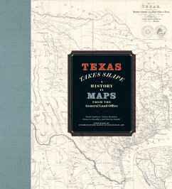
Texas Takes Shape
A History in Maps from the General Land Office
Mark Lambert, James Harkins, Brian A Stauffer, Patrick Walsh
Texas Takes Shape
A History in Maps from the General Land Office
- Gebundenes Buch
- Merkliste
- Auf die Merkliste
- Bewerten Bewerten
- Teilen
- Produkt teilen
- Produkterinnerung
- Produkterinnerung
A comprehensive volume on historical mapping in Texas.
Andere Kunden interessierten sich auch für
![Illinois: Mapping the Prairie State Through History: Rare and Unusual Maps from the Library of Congress Illinois: Mapping the Prairie State Through History: Rare and Unusual Maps from the Library of Congress]() Vincent VirgaIllinois: Mapping the Prairie State Through History: Rare and Unusual Maps from the Library of Congress22,99 €
Vincent VirgaIllinois: Mapping the Prairie State Through History: Rare and Unusual Maps from the Library of Congress22,99 €![Virginia: Mapping the Old Dominion State Through History: Rare and Unusual Maps from the Library of Congress Virginia: Mapping the Old Dominion State Through History: Rare and Unusual Maps from the Library of Congress]() Vincent VirgaVirginia: Mapping the Old Dominion State Through History: Rare and Unusual Maps from the Library of Congress22,99 €
Vincent VirgaVirginia: Mapping the Old Dominion State Through History: Rare and Unusual Maps from the Library of Congress22,99 €![Mapping the Adirondacks Mapping the Adirondacks]() Thatcher HoganMapping the Adirondacks31,99 €
Thatcher HoganMapping the Adirondacks31,99 €![Jamaica Jamaica]() John HendersonJamaica36,99 €
John HendersonJamaica36,99 €![How Texas Got Its Shape How Texas Got Its Shape]() Larry W JonesHow Texas Got Its Shape35,99 €
Larry W JonesHow Texas Got Its Shape35,99 €![Early History of Omaha; or, Walks and Talks Among the old Settlers: A Series of Sketches in the Shape of A Connected Narrative of the Events and Incid Early History of Omaha; or, Walks and Talks Among the old Settlers: A Series of Sketches in the Shape of A Connected Narrative of the Events and Incid]() Alfred Rasmus SorensonEarly History of Omaha; or, Walks and Talks Among the old Settlers: A Series of Sketches in the Shape of A Connected Narrative of the Events and Incid36,99 €
Alfred Rasmus SorensonEarly History of Omaha; or, Walks and Talks Among the old Settlers: A Series of Sketches in the Shape of A Connected Narrative of the Events and Incid36,99 €![Plat Book of Oconto County, Wisconsin Plat Book of Oconto County, Wisconsin]() Plat Book of Oconto County, Wisconsin29,99 €
Plat Book of Oconto County, Wisconsin29,99 €-
-
-
A comprehensive volume on historical mapping in Texas.
Hinweis: Dieser Artikel kann nur an eine deutsche Lieferadresse ausgeliefert werden.
Hinweis: Dieser Artikel kann nur an eine deutsche Lieferadresse ausgeliefert werden.
Produktdetails
- Produktdetails
- Verlag: University of Texas Press
- Seitenzahl: 360
- Erscheinungstermin: 1. Juli 2025
- Englisch
- Gewicht: 454g
- ISBN-13: 9781477330920
- ISBN-10: 1477330925
- Artikelnr.: 71985675
- Herstellerkennzeichnung
- Libri GmbH
- Europaallee 1
- 36244 Bad Hersfeld
- gpsr@libri.de
- Verlag: University of Texas Press
- Seitenzahl: 360
- Erscheinungstermin: 1. Juli 2025
- Englisch
- Gewicht: 454g
- ISBN-13: 9781477330920
- ISBN-10: 1477330925
- Artikelnr.: 71985675
- Herstellerkennzeichnung
- Libri GmbH
- Europaallee 1
- 36244 Bad Hersfeld
- gpsr@libri.de
Mark Lambert is the Senior Deputy Director for Heritage at the Texas General Land Office. James Harkins is the Deputy Director of Archives and Records. Brian A. Stauffer is the Director of Public Services and the author of Victory on Earth or in Heaven: Mexico’s Religionero Rebellion. Patrick Walsh is a research specialist.
1. List of Maps
2. Foreword by Dawn Buckingham
3. Preface
4. Introduction
5. Part I. Defining Texas
* Chapter 1. Mapping the New World: An Age of Discovery
* Beyond the Neatline—Uncovering the Base Layer: Indigenous Cartography
in North America
* Chapter 2. Competing Empires: Maps as Knowledge and Power, 1671–1830
* Beyond the Neatline—Compasses and Crucifixes: Priests and Friars in
the Mapping of Spanish North America
* Chapter 3. Mapping Mexico: Uneven Geography
* Beyond the Neatline—From the “Dead Desert” to the “Wonderland of
Agriculture and Opportunity”: Mapping the Nueces Strip 000:
* Chapter 4. The Lone Star Rises: Maps of the Republic of Texas,
1835–1846
* Beyond the Neatline—”A continued succession of abrupt sinuousities”:
The Joint Boundary Commission and the Republic of Texas, 1838–1841
* Chapter 5. “The Republic of Texas is no more”: The Lone Star State
Takes Shape
* Beyond the Neatline—The Art and Cartography of Eltea Armstrong
6. Part II. Developing Texas
* Chapter 6. Contested Frontier: Pathfinders, Soldiers, and Military
Maps
* Beyond the Neatline—Land for Military Service: Bounty, Donation, and
Confederate Scrip
* Chapter 7. Connecting a Continent: Texas Land and the Expanding
American Railroad System
* Beyond the Neatline—Frontier Surveying in Texas
* Chapter 8. All Boundaries Are Local: GLO County Maps
* Beyond the Neatline—Drawing Conclusions: Manuscript Cartouches in the
GLO
* Chapter 9. The Growth and Urbanization of Texas: City Maps at the GLO
* Beyond the Neatline—”Complete Success” to Obsolescence: The
Photographic Bureau of the GLO, 1861–1874
7. Conclusions. Texas History on the Digital Frontier: Improving Access
through Preservation
8. Acknowledgments
9. Notes
10. Index
11. About the Authors

