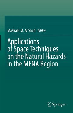
Applications of Space Techniques on the Natural Hazards in the MENA Region (eBook, PDF)
Redaktion: Al Saud, Mashael M.


Alle Infos zum eBook verschenken

Applications of Space Techniques on the Natural Hazards in the MENA Region (eBook, PDF)
Redaktion: Al Saud, Mashael M.
- Format: PDF
- Merkliste
- Auf die Merkliste
- Bewerten Bewerten
- Teilen
- Produkt teilen
- Produkterinnerung
- Produkterinnerung

Hier können Sie sich einloggen

Bitte loggen Sie sich zunächst in Ihr Kundenkonto ein oder registrieren Sie sich bei bücher.de, um das eBook-Abo tolino select nutzen zu können.
This book introduces a comprehensive understanding in the use of space techniques in natural hazards and risk management in the MENA Region. The book is based on different case-studies from 25 MENA countries, and will be useful in highlighting the issues from all aspects.
In recent years the number of natural hazard events has increased in the MENA Region. This is exacerbated by the changing climate and extreme climate events, as well as a large increase in the population in this area. Disastrous events occur on a yearly basis characterized by a vulnerability of physical processes. Floods,…mehr
- Geräte: PC
- ohne Kopierschutz
- eBook Hilfe
- Größe: 33.32MB
![Climate Change and Environmental Degradation in the MENA Region (eBook, PDF) Climate Change and Environmental Degradation in the MENA Region (eBook, PDF)]() Climate Change and Environmental Degradation in the MENA Region (eBook, PDF)137,95 €
Climate Change and Environmental Degradation in the MENA Region (eBook, PDF)137,95 €![Monitoring and Managing Multi-hazards (eBook, PDF) Monitoring and Managing Multi-hazards (eBook, PDF)]() Monitoring and Managing Multi-hazards (eBook, PDF)121,95 €
Monitoring and Managing Multi-hazards (eBook, PDF)121,95 €![Climate, Environment and Disaster in Developing Countries (eBook, PDF) Climate, Environment and Disaster in Developing Countries (eBook, PDF)]() Climate, Environment and Disaster in Developing Countries (eBook, PDF)121,95 €
Climate, Environment and Disaster in Developing Countries (eBook, PDF)121,95 €![Human Ecology of Climate Change Hazards in Vietnam (eBook, PDF) Human Ecology of Climate Change Hazards in Vietnam (eBook, PDF)]() An Thinh NguyenHuman Ecology of Climate Change Hazards in Vietnam (eBook, PDF)73,95 €
An Thinh NguyenHuman Ecology of Climate Change Hazards in Vietnam (eBook, PDF)73,95 €- -23%11
![Hope and Courage in the Climate Crisis (eBook, PDF) Hope and Courage in the Climate Crisis (eBook, PDF)]() John WisemanHope and Courage in the Climate Crisis (eBook, PDF)22,95 €
John WisemanHope and Courage in the Climate Crisis (eBook, PDF)22,95 € ![Atmospheric Chemistry in the Mediterranean Region (eBook, PDF) Atmospheric Chemistry in the Mediterranean Region (eBook, PDF)]() Atmospheric Chemistry in the Mediterranean Region (eBook, PDF)73,95 €
Atmospheric Chemistry in the Mediterranean Region (eBook, PDF)73,95 €![Mitigation of Dangers from Natural and Anthropogenic Hazards (eBook, PDF) Mitigation of Dangers from Natural and Anthropogenic Hazards (eBook, PDF)]() Frederic R. SiegelMitigation of Dangers from Natural and Anthropogenic Hazards (eBook, PDF)40,95 €
Frederic R. SiegelMitigation of Dangers from Natural and Anthropogenic Hazards (eBook, PDF)40,95 €-
-
-
In recent years the number of natural hazard events has increased in the MENA Region. This is exacerbated by the changing climate and extreme climate events, as well as a large increase in the population in this area. Disastrous events occur on a yearly basis characterized by a vulnerability of physical processes. Floods, earthquakes, and mass movement result in severe damage to property and livelihoods, and have devastating effects upon the environment. These events cause severe financial losses, which on an annual basis, can exceed millions of dollars.
The predication, assessment and monitoring approaches remain inadequate in managing these hazards and in mitigating their impacts, but with the development of space techniques and geo-information systems, these situations can now be better managed. The miscellany of satellite images, with different spatial and temporal resolutions, enable the detection of terrain features and provide indications of potential natural risks.
This book will of interest to stakeholders, including field experts, academics, researchers and decision makers.
Dieser Download kann aus rechtlichen Gründen nur mit Rechnungsadresse in A, B, BG, CY, CZ, D, DK, EW, E, FIN, F, GR, HR, H, IRL, I, LT, L, LR, M, NL, PL, P, R, S, SLO, SK ausgeliefert werden.
- Produktdetails
- Verlag: Springer International Publishing
- Seitenzahl: 635
- Erscheinungstermin: 29. April 2022
- Englisch
- ISBN-13: 9783030888749
- Artikelnr.: 63926884
- Verlag: Springer International Publishing
- Seitenzahl: 635
- Erscheinungstermin: 29. April 2022
- Englisch
- ISBN-13: 9783030888749
- Artikelnr.: 63926884
- Herstellerkennzeichnung Die Herstellerinformationen sind derzeit nicht verfügbar.
