Elizabeth ByersThe Official Guide for Hikers, Mountain Bikers, and Equestrians
Bay Area Ridge Trail (eBook, ePUB)
The Official Guide for Hikers, Mountain Bikers, and Equestrians
Mitwirkender: Rusmore, Jean
14,95 €
14,95 €
inkl. MwSt.
Sofort per Download lieferbar

7 °P sammeln
14,95 €
Als Download kaufen

14,95 €
inkl. MwSt.
Sofort per Download lieferbar

7 °P sammeln
Jetzt verschenken
Alle Infos zum eBook verschenken
14,95 €
inkl. MwSt.
Sofort per Download lieferbar
Alle Infos zum eBook verschenken

7 °P sammeln
Elizabeth ByersThe Official Guide for Hikers, Mountain Bikers, and Equestrians
Bay Area Ridge Trail (eBook, ePUB)
The Official Guide for Hikers, Mountain Bikers, and Equestrians
Mitwirkender: Rusmore, Jean
- Format: ePub
- Merkliste
- Auf die Merkliste
- Bewerten Bewerten
- Teilen
- Produkt teilen
- Produkterinnerung
- Produkterinnerung

Bitte loggen Sie sich zunächst in Ihr Kundenkonto ein oder registrieren Sie sich bei
bücher.de, um das eBook-Abo tolino select nutzen zu können.
Hier können Sie sich einloggen
Hier können Sie sich einloggen
Sie sind bereits eingeloggt. Klicken Sie auf 2. tolino select Abo, um fortzufahren.

Bitte loggen Sie sich zunächst in Ihr Kundenkonto ein oder registrieren Sie sich bei bücher.de, um das eBook-Abo tolino select nutzen zu können.
Find Solitude and Dramatic Views Around San Francisco Bay
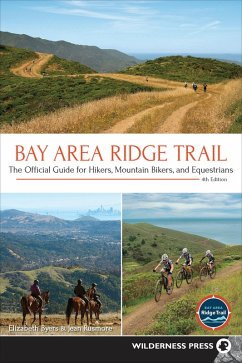
Everyone needs a break from their daily life. Escape to the oak-studded grasslands and tranquil forests of the Bay Area Ridge Trail. Hike, bike, or ride through nine counties with the official guide endorsed by the Bay Area Ridge Trail Council. Discover dramatic coastlines, a range of ecosystems, former Mexican ranchos, vistas that inspired Spanish explorers, and more.
Join author Elizabeth Byers-a founding board member of the council-and Jean Rusmore, and choose from 75 trail segments on a network of paths that ring San…mehr
- Geräte: eReader
- mit Kopierschutz
- eBook Hilfe
- Größe: 45.69MB
Andere Kunden interessierten sich auch für
![Moon 101 Great Hikes San Francisco Bay Area (eBook, ePUB) Moon 101 Great Hikes San Francisco Bay Area (eBook, ePUB)]() Ann Marie BrownMoon 101 Great Hikes San Francisco Bay Area (eBook, ePUB)4,49 €
Ann Marie BrownMoon 101 Great Hikes San Francisco Bay Area (eBook, ePUB)4,49 €![One Night Wilderness: San Francisco Bay Area (eBook, ePUB) One Night Wilderness: San Francisco Bay Area (eBook, ePUB)]() Matt HeidOne Night Wilderness: San Francisco Bay Area (eBook, ePUB)9,95 €
Matt HeidOne Night Wilderness: San Francisco Bay Area (eBook, ePUB)9,95 €![Moon 101 Great Hikes San Francisco Bay Area (eBook, ePUB) Moon 101 Great Hikes San Francisco Bay Area (eBook, ePUB)]() Ann Marie BrownMoon 101 Great Hikes San Francisco Bay Area (eBook, ePUB)11,99 €
Ann Marie BrownMoon 101 Great Hikes San Francisco Bay Area (eBook, ePUB)11,99 €![Rail-Trails Iowa & Missouri (eBook, ePUB) Rail-Trails Iowa & Missouri (eBook, ePUB)]() Rails-To-Trails ConservancyRail-Trails Iowa & Missouri (eBook, ePUB)10,95 €
Rails-To-Trails ConservancyRail-Trails Iowa & Missouri (eBook, ePUB)10,95 €![Rail-Trails Pennsylvania (eBook, ePUB) Rail-Trails Pennsylvania (eBook, ePUB)]() Rails-To-Trails ConservancyRail-Trails Pennsylvania (eBook, ePUB)11,95 €
Rails-To-Trails ConservancyRail-Trails Pennsylvania (eBook, ePUB)11,95 €![Rail-Trails Washington & Oregon (eBook, ePUB) Rail-Trails Washington & Oregon (eBook, ePUB)]() Rails-To-Trails ConservancyRail-Trails Washington & Oregon (eBook, ePUB)10,95 €
Rails-To-Trails ConservancyRail-Trails Washington & Oregon (eBook, ePUB)10,95 €![Best Day Hikes on the Arizona National Scenic Trail (eBook, ePUB) Best Day Hikes on the Arizona National Scenic Trail (eBook, ePUB)]() Sirena RanaBest Day Hikes on the Arizona National Scenic Trail (eBook, ePUB)11,95 €
Sirena RanaBest Day Hikes on the Arizona National Scenic Trail (eBook, ePUB)11,95 €-
-
-
Find Solitude and Dramatic Views Around San Francisco Bay
Everyone needs a break from their daily life. Escape to the oak-studded grasslands and tranquil forests of the Bay Area Ridge Trail. Hike, bike, or ride through nine counties with the official guide endorsed by the Bay Area Ridge Trail Council. Discover dramatic coastlines, a range of ecosystems, former Mexican ranchos, vistas that inspired Spanish explorers, and more.
Join author Elizabeth Byers-a founding board member of the council-and Jean Rusmore, and choose from 75 trail segments on a network of paths that ring San Francisco Bay. Make your way through parks and public lands like Mount Tamalpais State Park and Sierra Azul Open Space Preserve. Trips range from a 2.5-mile excursion over the Benicia-Martinez Bridge to a 12.5-mile traverse of Bolinas Ridge. You can also link several trips together to create a continuous trek that is 20, 40, or even 80 miles long.
Each trip includes summary information, like distance, accessibility, regulations, and facilities, as well as an easy-to-read map. Comprehensive trail directions help to ensure that you always know where to go, while details on the region's history and culture entertain you along the way. Grab the updated, full-color edition of Bay Area Ridge Trail and start planning your next adventure. The perfect outing is closer than you think.
Dieser Download kann aus rechtlichen Gründen nur mit Rechnungsadresse in A, D ausgeliefert werden.
Produktdetails
- Produktdetails
- Verlag: Wilderness Press
- Erscheinungstermin: 16. April 2019
- Englisch
- ISBN-13: 9780899979069
- Artikelnr.: 57547405
- Verlag: Wilderness Press
- Erscheinungstermin: 16. April 2019
- Englisch
- ISBN-13: 9780899979069
- Artikelnr.: 57547405
- Herstellerkennzeichnung Die Herstellerinformationen sind derzeit nicht verfügbar.
A Mill Valley resident and native Northern Californian, Elizabeth Byers has lived in the San Francisco Bay Area for most of her life. As a child and teenager, she explored the beautiful mountains of Carmel Valley and Big Sur near her home. Her love of the outdoors led her to study environmental planning in college and graduate school at the University of California, Berkeley. She began working in the land conservation field in the mid-1980s, for 16 years as a project manager, program director, and writer at the Trust for Public Land (TPL) and then as a consultant for many nonprofits and agencies, including the Garden Conservancy, the Bay Area Ridge Trail Council, and TPL.
In 1988, while at TPL, Elizabeth became one of the founding board members of the Bay Area Ridge Trail Council, and she stayed connected to the organization over the years. She coauthored the second edition of The Conservation Easement Handbook, copublished by TPL and the Land Trust Alliance in 2005, and was a photographer and project coordinator for the 2014 Golden Gate National Parks Conservancy publication Alcatraz Gardens: Remembered, Reclaimed, Reimagined. She is a mom to two children in their 20s who grew up on the lower slopes of Mount Tamalpais.
Elizabeth hiked, biked, and photographed the Ridge Trail to update this guidebook, often with family and friends, and this journey reconfirmed for her the magnificence of the Bay Area landscape.
Jean Rusmore, the author of this book's first three editions, grew up in what was once the small town of Anaheim, California, in the county that boasted orange and lemon groves as its namesake. She took her first backpacking trip at age 16, when she and a cousin ascended the slopes of Mount Wilson in the San Gabriel Mountains with some food and a jacket rolled up in a blanket. Her outdoor experience was enlarged through her husband, Ted, whom she met at the University of California, Berkeley. They skied and backpacked with their six children, and all looked forward to their annual Sierra backpacking trip.
When the Midpeninsula Regional Open Space District was established, Jean and her friend Frances Spangle decided to write a book about the new foothill preserves, Peninsula Trails, followed by South Bay Trails, both published by Wilderness Press. When the first segments of the Ridge Trail opened, they wrote pamphlets about each leg. These were later combined and published as the first edition of this book.
Overview Map
Foreword
An Inspired Vision to Connect People, Parks, and Open Space
Acknowledgments
The San Francisco Bay Area
The Bay Area Ridge Trail
How to Use This Book
Trail Sampler: Trips for Many Reasons
North Bay
* The Golden Gate Bridge
* Marin Headlands from the Golden Gate Bridge to Tennessee Valley
* Marin Headlands from Tennessee Valley to Shoreline Highway
* Mount Tamalpais State Park and Dias Ridge Trail
* Mount Tamalpais State Park and Bolinas Ridge
* Bolinas Ridge and Samuel P. Taylor State Park
* Samuel P. Taylor State Park to White Hill Open Space Preserve
* Loma Alta Open Space Preserve and Loma Alta Fire Road
* Lucas Valley Open Space Preserve
* Indian Tree Open Space Preserve
* Stafford Lake Watershed to O'Hair Park
* Mount Burdell Open Space Preserve
* Petaluma: Helen Putnam Regional Park and City of Petaluma
* Jack London State Historic Park and East Slope Sonoma Mountain Ridge
Trail
* Jack London State Historic Park and North Sonoma Mountain Regional
Park and Open Space Preserve
* Spring Lake Regional Park and Trione-Annadel State Park
* Hood Mountain Regional Park and Open Space Preserve
* Bothe-Napa Valley State Park
* Robert Louis Stevenson State Park: Lower Oat Hill Mine Trail
* Robert Louis Stevenson State Park: Table Rock and Palisades Trails
Spur
* Robert Louis Stevenson State Park: Mount St. Helena Spur
* Moore Creek Park
* Skyline Wilderness Park and Napa Solano Ridge Trail
* Rockville Hills Regional Park and Vintage Valley Trail
* Lynch Canyon Open Space and McGary Road
* Hiddenbrooke Open Space
* Blue Rock Springs Park to Vallejo-Benicia Buffer
* Vallejo-Benicia Waterfront
* Benicia-Martinez Bridge
East Bay
* Carquinez Bridge and Crockett
* Crockett Hills Regional Park
* Fernandez Ranch
* Martinez City Streets
* Carquinez Strait Regional Shoreline and John Muir National Historic
Site
* Contra Costa Feeder Trail #1
* Pinole Valley Watershed
* Pinole Valley Watershed West and Sobrante Ridge Regional Preserve
* Kennedy Grove Regional Recreation Area to Tilden Regional Park
* Tilden Regional Park to Redwood Regional Park
* Redwood and Anthony Chabot Regional Parks
* Anthony Chabot Regional Park
* East Bay Municipal Utility District Lands and Cull Canyon Regional
Recreation Area
* Cull Canyon Regional Recreation Area to Five Canyons Parkway
* Five Canyons Parkway to Garin/Dry Creek Pioneer Regional Parks
* Vargas Plateau Regional Park
* Mission Peak Regional Preserve and Ed R. Levin County Park
South Bay
* Penitencia Creek
* Alum Rock Park and Sierra Vista Open Space Preserve
* Sierra Vista Open Space Preserve
* Joseph D. Grant County Park
* Coyote Creek Parkway North
* Coyote Creek Parkway South
* Coyote Lake-Harvey Bear Ranch County Park
* Mount Madonna County Park
* Santa Teresa County Park and Calero Creek/Los Alamitos Creek Trails
* Almaden Quicksilver County Park
* Sierra Azul Open Space Preserve and Lexington Reservoir County Park
* Sierra Azul Open Space Preserve: Mount Umunhum
* Sanborn County Park: John Nicholas Trail
* Sanborn County Park and Castle Rock State Park
The Peninsula
* Saratoga Gap Open Space Preserve to Skyline Ridge Open Space Preserve
* Skyline Ridge and Russian Ridge Open Space Preserves
* Windy Hill Open Space Preserve
* Wunderlich County Park to Huddart County Park
* Purisima Creek Redwoods Open Space Preserve
* Skylawn Memorial Park
* San Francisco Peninsula Watershed
* Sweeney Ridge
* Skyline College, Milagra Ridge, and Pacifica
* Mussel Rock to Lake Merced
San Francisco
* Lake Merced to Stern Grove
* Stern Grove to the Presidio
* San Francisco Presidio
Appendix 1: Information Sources and Contacts for Parks and Watersheds on
the Bay Area Ridge Trail Route
Appendix 2: Transportation Agencies That Serve the Bay Area Ridge Trail
Route
Index
About the Authors
