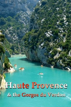
Along the Côte d'Azur and the Riviera, this region is usually referred to as l'arrière pays - the back country. If you love dramatic landscapes, nearly vertical gorges, calm mountain lakes and valleys so deep and tight they have their own climates, you can't help finding Haute Provence thrillingly beautiful. This is where the mellow- , vine- , olive- and lavender-covered hills give way to abrupt and challenging Alpine landscapes. There is no clear line of demarcation. Instead, the landscape folds back and forth upon itself, seeming to suggest the giant tectonic forces that created the Alps. This is kayaking, rafting and canyoning territory, an area for real, open-air or lodge camping, for gîtes and hostels. There are splendid hikes, lake-based watersports, heart-stopping drives, mountaineering and the uniquely European climbing sport of via ferrata. In this book the principal destinations are the gorges and mountains themselves, rather than the villages and towns that provide stopping places in a landscape so wild that much of it was undiscovered before the beginning of the 20th century. The Gorges du Verdon, which mark the border between the French Départments of Var and Alpes de Haute Provence, were carved into the limestone by the Verdon River, plunging down from its source, about 2,500 m/8,200 feet higher up in the Alps. The colorful walls of the gorge rise up to 700 m/2,300 feet above the opaque green river. The emerald green color, by the way, is not the result of pollution. The river has always been thus and, in fact, its name comes from the French for green - vert. The color and opacity may be the result of dissolved limestone mixing with microscopic plant life. At its base, the canyon measures between six and 100 m (20-328 feet) wide, while at the rim it spreads to between and 200 and 1,500 m (650 to 5,000 feet). The Gorge, a protected Regional Nature Park, is Europe's deepest. As such, it has it's own, colder climate - parts of it barely see the sun. While you will find typical Provençal flora and fauna along the rim, the deep, cool reaches of the gorge are scattered with Alpine plants, boxwood and, in spring, pomponium lilies, small Alpine mammals and so many chamois that they are a common sight. Vultures, which were nearly extinct in this area, have been successfully reintroduced. If you'd like to see the many "cluses" - the steep-sided, transverse valleys that crisscross the area - to drive along the crests and ridges of the gorges and to enjoy the sweeping views of the Alps, the Mediterranean and the many perched villages, consider driving the Route Napoléon. This is the route taken by Napoleon upon his return from Elba. Coming ashore with 1,000 troops at Golfe Juan in March 1815, he traveled through Haute Provence to Grenoble over the next six days. Besides being a tremendously scenic (and in some places a hair-raising drive for anyone with a fear of heights), the route is a sort of French pilgrimage, with historic markers along the way noting the houses, inns and châteaux that harbored the returning emperor. A large spa and market town on the edge of the Alps, Digne is the capital of the lavender country of Haute Provence. It sits beside the fast-flowing Bléone river and is surrounded by heavily forested, steep and mountainous hiking country. The town has a compact center and a pretty main street lined with plane trees. These are just a few of the attractions here. This guide contains all the details you need: how to get around, where to stay, where to eat, the history, what to see and more.
Dieser Download kann aus rechtlichen Gründen nur mit Rechnungsadresse in A, B, BG, CY, CZ, D, DK, EW, E, FIN, F, GR, HR, H, IRL, I, LT, L, LR, M, NL, PL, P, R, S, SLO, SK ausgeliefert werden.


