Stacy A. C. Nelson, Siamak Khorram
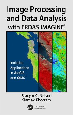
Image Processing and Data Analysis with ERDAS IMAGINE® (eBook, ePUB)
160,95 €
160,95 €
inkl. MwSt.
Sofort per Download lieferbar

80 °P sammeln
160,95 €
Als Download kaufen

160,95 €
inkl. MwSt.
Sofort per Download lieferbar

80 °P sammeln
Jetzt verschenken
Alle Infos zum eBook verschenken
160,95 €
inkl. MwSt.
Sofort per Download lieferbar
Alle Infos zum eBook verschenken

80 °P sammeln
Stacy A. C. Nelson, Siamak Khorram
Image Processing and Data Analysis with ERDAS IMAGINE® (eBook, ePUB)
- Format: ePub
- Merkliste
- Auf die Merkliste
- Bewerten Bewerten
- Teilen
- Produkt teilen
- Produkterinnerung
- Produkterinnerung

Bitte loggen Sie sich zunächst in Ihr Kundenkonto ein oder registrieren Sie sich bei
bücher.de, um das eBook-Abo tolino select nutzen zu können.
Hier können Sie sich einloggen
Hier können Sie sich einloggen
Sie sind bereits eingeloggt. Klicken Sie auf 2. tolino select Abo, um fortzufahren.

Bitte loggen Sie sich zunächst in Ihr Kundenkonto ein oder registrieren Sie sich bei bücher.de, um das eBook-Abo tolino select nutzen zu können.
Globally, a wide variety of organizations rely on ERDAS IMAGINE® daily, including local, state and national mapping agencies, transportation departments, defense organizations, engineering and utility companies and many more.
- Geräte: eReader
- mit Kopierschutz
- eBook Hilfe
- Größe: 53.69MB
Andere Kunden interessierten sich auch für
![SAR Image Interpretation for Various Land Covers (eBook, ePUB) SAR Image Interpretation for Various Land Covers (eBook, ePUB)]() Elizabeth SimmsSAR Image Interpretation for Various Land Covers (eBook, ePUB)48,95 €
Elizabeth SimmsSAR Image Interpretation for Various Land Covers (eBook, ePUB)48,95 €![Image Processing and Data Analysis with ERDAS IMAGINE® (eBook, PDF) Image Processing and Data Analysis with ERDAS IMAGINE® (eBook, PDF)]() Stacy A. C. NelsonImage Processing and Data Analysis with ERDAS IMAGINE® (eBook, PDF)160,95 €
Stacy A. C. NelsonImage Processing and Data Analysis with ERDAS IMAGINE® (eBook, PDF)160,95 €![Remote Sensing Image Fusion (eBook, ePUB) Remote Sensing Image Fusion (eBook, ePUB)]() Christine PohlRemote Sensing Image Fusion (eBook, ePUB)54,95 €
Christine PohlRemote Sensing Image Fusion (eBook, ePUB)54,95 €![Remote Sensing and Image Processing in Mineralogy (eBook, ePUB) Remote Sensing and Image Processing in Mineralogy (eBook, ePUB)]() Maged MarghanyRemote Sensing and Image Processing in Mineralogy (eBook, ePUB)71,95 €
Maged MarghanyRemote Sensing and Image Processing in Mineralogy (eBook, ePUB)71,95 €![Building Feature Extraction with Machine Learning (eBook, ePUB) Building Feature Extraction with Machine Learning (eBook, ePUB)]() Bharath. H. AithalBuilding Feature Extraction with Machine Learning (eBook, ePUB)47,95 €
Bharath. H. AithalBuilding Feature Extraction with Machine Learning (eBook, ePUB)47,95 €![Fuzzy Machine Learning Algorithms for Remote Sensing Image Classification (eBook, ePUB) Fuzzy Machine Learning Algorithms for Remote Sensing Image Classification (eBook, ePUB)]() Anil KumarFuzzy Machine Learning Algorithms for Remote Sensing Image Classification (eBook, ePUB)54,95 €
Anil KumarFuzzy Machine Learning Algorithms for Remote Sensing Image Classification (eBook, ePUB)54,95 €![Polarimetric SAR Imaging (eBook, ePUB) Polarimetric SAR Imaging (eBook, ePUB)]() Yoshio YamaguchiPolarimetric SAR Imaging (eBook, ePUB)55,95 €
Yoshio YamaguchiPolarimetric SAR Imaging (eBook, ePUB)55,95 €-
-
-
Globally, a wide variety of organizations rely on ERDAS IMAGINE® daily, including local, state and national mapping agencies, transportation departments, defense organizations, engineering and utility companies and many more.
Hinweis: Dieser Artikel kann nur an eine deutsche Lieferadresse ausgeliefert werden.
Dieser Download kann aus rechtlichen Gründen nur mit Rechnungsadresse in A, B, BG, CY, CZ, D, DK, EW, E, FIN, F, GR, HR, H, IRL, I, LT, L, LR, M, NL, PL, P, R, S, SLO, SK ausgeliefert werden.
Hinweis: Dieser Artikel kann nur an eine deutsche Lieferadresse ausgeliefert werden.
Produktdetails
- Produktdetails
- Verlag: Taylor & Francis eBooks
- Seitenzahl: 350
- Erscheinungstermin: 3. Oktober 2018
- Englisch
- ISBN-13: 9781351980586
- Artikelnr.: 54537376
- Verlag: Taylor & Francis eBooks
- Seitenzahl: 350
- Erscheinungstermin: 3. Oktober 2018
- Englisch
- ISBN-13: 9781351980586
- Artikelnr.: 54537376
- Herstellerkennzeichnung Die Herstellerinformationen sind derzeit nicht verfügbar.
Dr. Stacy A. C. Nelson is an associate professor in the College of Natural Resources' Center for Geospatial Analytics, the Department of Forestry and Environmental Resources, and the Fisheries, Wildlife, and Conservation Science Program at North Carolina State University, since 2002. Dr. Nelson's research interests focus on the use of geospatial technologies to address both regional and localscale questions of land use and land cover change and the impact this change has on aquatic ecosystems. Dr. Nelson earned a B.S. in biology from Jackson State University (1990). He completed a master's degree from the College of William and Mary's school of marine science-the Virginia Institute of Marine Science (1995). His Ph.D. was completed in Limnology from Michigan State University's Department of Fisheries and Wildlife (2002), where Dr. Nelson attended graduate school as a NASA graduate research fellow. During 2010, Dr. Nelson served a year-long Federal Intergovernmental Personnel Act appointment within the National Headquarters of the USDA Forest Service's Office of Civil Rights in Washington D.C. In D.C., Dr. Nelson worked with the Forest Service and multiple agencies to expand working partnerships between majority-serving and minority-serving Land-Grant Universities in an effort to increase shared research capacities, curricula, and diversity among institutions.
Dr. Khorram is a Professor of Remote Sensing and Image processing. He holds a joint faculty appointment at UC Berkeley and North Carolina State University. He received a MS. in Engineering and another MS in Ecology from the University of California (UC) at Davis and his Ph.D. under a joint program from UC Berkeley and Davis. From 1976 to 1980, he served as the Principal Scientist at the Space Sciences Laboratory at UC Berkeley. He then joined the faculty in North Carolina State University (NCSU) in Forestry and Environmental Resources and in Electrical and Computer Engineering departments. He has served as the Principal Investigator for well over 60 major research projects. His research projects have focused on remote sensing, image processing, and geospatial information technology. He has developed a number of image classification and multiresolution data fusion systems as applied to land use and land cover classifications and geospatial modeling. The primary areas of interest and expertise in his research is in natural resources (including water quality) mapping, monitoring, and change detection based on conventional remote sensing techniques as well as automated procedures for image registration, classification, and change detection.
Dr. Khorram is a Professor of Remote Sensing and Image processing. He holds a joint faculty appointment at UC Berkeley and North Carolina State University. He received a MS. in Engineering and another MS in Ecology from the University of California (UC) at Davis and his Ph.D. under a joint program from UC Berkeley and Davis. From 1976 to 1980, he served as the Principal Scientist at the Space Sciences Laboratory at UC Berkeley. He then joined the faculty in North Carolina State University (NCSU) in Forestry and Environmental Resources and in Electrical and Computer Engineering departments. He has served as the Principal Investigator for well over 60 major research projects. His research projects have focused on remote sensing, image processing, and geospatial information technology. He has developed a number of image classification and multiresolution data fusion systems as applied to land use and land cover classifications and geospatial modeling. The primary areas of interest and expertise in his research is in natural resources (including water quality) mapping, monitoring, and change detection based on conventional remote sensing techniques as well as automated procedures for image registration, classification, and change detection.
