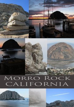
This edition is a stunning photographic survey capturing the diversity and varied perspectives of the sacred monolith. Morro Rock is the most prominent of the Nine Sister mountain range located within San Luis Obispo County and fronts a beachfront gateway to the city of Morro Bay, California.
The ancient sacred rock is geographically termed a protruding plug rising from the Pacific Ocean. A volcanic plug can also be called a neck as it is an object formed when magma hardens within a vent on an active volcano. A man-made causeway and harbor connects the rock with the shore giving it the resemblance of an island. Morro Rock was initially surrounded by water but the northern channel's harbor was later created from its sediment.
The indigenous Salinan and Chumash tribes considered Morro Rock to be a sacred site. It is speculated that the Chumash settlements date back to the Millingstone Horizon era (6500-2000 B.C). Both tribes' members are given the right to climb Morro Rock for their annual solstice ceremony, a privilege denied to the general public.
The Salinan's legend behind the rock is based on the recounting of a time when hawk and raven combined to destroy a two-headed serpent called Taliyekatapelta as he wrapped his body around the base of the rock.
Although heralded by the original native residents, 18th century Spanish explorers christened Morro Rock. Juan Rodriguez Cabrillo likely viewed the rock during his Pacific maritime expedition in 1542. The Spanish Portola expedition charting Alta California arrived in September 1769 into the Los Osos Valley and camped in the Morro Bay territory. This Portola group was also responsible for the mapping of the Los Angeles El Pueblo settlement further south.
A Franciscan missionary and expedition member, Juan Crespi is credited with naming rights by identifying the roundish navigational stone as a morro (Spanish word for rounded head). Morro Rock has since served as an important and critical navigational landmark. The rock was quarried between 1889 until 1969 and the stone used as material for the breakwater of Morro Bay and Port San Luis Harbor (adjacent to Avila Beach). Reason ultimately prevailed and the rock is currently legally protected from further destruction.
The western view of Morro Rock is intimately visible only from an aerial or Pacific Ocean vantage perspective. The entrance to Morro Harbor is considered extremely treacherous and has proved monstrous to generations of piloting boatmen.
Morro Rock is but one of thirteen ancient volcanic plugs that stretch submerged beneath the Pacific Ocean into distinctive peaks along Highway 101 just south of San Luis Obispo. The nine visible names affectionately called the Nine Sisters include Morro Rock (581'), Black Hill (665'), Cerro Cabrillo (911'), Hollister Peak (1404'), Cerro Romauldo (1306'), Chumash Peak (1257'), Bishop Peak (1292'), Cerro San Luis (1292') and Islay Hill (775'). Each can be mounted with the exception of Morro Rock.
Dieser Download kann aus rechtlichen Gründen nur mit Rechnungsadresse in A, B, CY, CZ, D, DK, EW, E, FIN, F, GR, H, IRL, I, LT, L, LR, M, NL, PL, P, R, S, SLO, SK ausgeliefert werden.