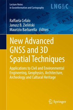
New Advanced GNSS and 3D Spatial Techniques (eBook, PDF)
Applications to Civil and Environmental Engineering, Geophysics, Architecture, Archeology and Cultural Heritage
223,63 €
inkl. MwSt.
Sofort per Download lieferbar
New Advanced GNSS and 3D Spatial Techniques (eBook, PDF)
Applications to Civil and Environmental Engineering, Geophysics, Architecture, Archeology and Cultural Heritage
- Format: PDF
- Merkliste
- Auf die Merkliste
- Bewerten Bewerten
- Teilen
- Produkt teilen
- Produkterinnerung
- Produkterinnerung
Bitte loggen Sie sich zunächst in Ihr Kundenkonto ein oder registrieren Sie sich bei
bücher.de, um das eBook-Abo tolino select nutzen zu können.
Hier können Sie sich einloggen
Sie sind bereits eingeloggt. Klicken Sie auf 2. tolino select Abo, um fortzufahren.
Bitte loggen Sie sich zunächst in Ihr Kundenkonto ein oder registrieren Sie sich bei bücher.de, um das eBook-Abo tolino select nutzen zu können.
This book provides the latest research on and applications of advanced GNSS (Global Navigation Satellite System) and 3D spatial techniques in the fields of Civil and Environmental Engineering, Geophysics, Architecture, Archaeology and Cultural Heritage.
It offers an updated reference guide on the above-mentioned topics for undergraduate and graduate students, PhDs, researchers, professionals and practitioners alike.
- Geräte: PC
- ohne Kopierschutz
- eBook Hilfe
- Größe: 12.21MB
- Upload möglich
Andere Kunden interessierten sich auch für
- Latin American Heritage (eBook, PDF)53,49 €
- Remote Sensing for Archaeology and Cultural Landscapes (eBook, PDF)171,19 €
- Bernhard Hofmann-WellenhofGNSS – Global Navigation Satellite Systems (eBook, PDF)171,19 €
- Erik W. GrafarendMap Projections (eBook, PDF)142,95 €
- Heritage and the Sea (eBook, PDF)160,49 €
- Digital Cultural Heritage (eBook, PDF)223,63 €
- Agent-based Modeling and Simulation in Archaeology (eBook, PDF)96,29 €
-
-
-
This book provides the latest research on and applications of advanced GNSS (Global Navigation Satellite System) and 3D spatial techniques in the fields of Civil and Environmental Engineering, Geophysics, Architecture, Archaeology and Cultural Heritage.
It offers an updated reference guide on the above-mentioned topics for undergraduate and graduate students, PhDs, researchers, professionals and practitioners alike.
Produktdetails
- Produktdetails
- Verlag: Springer International Publishing
- Erscheinungstermin: 7. Juli 2017
- Englisch
- ISBN-13: 9783319562186
- Artikelnr.: 52942017
- Verlag: Springer International Publishing
- Erscheinungstermin: 7. Juli 2017
- Englisch
- ISBN-13: 9783319562186
- Artikelnr.: 52942017
Part 1: New Advanced GNSS and 3D Spatial Techniques – Applications to Geodetic Networks, Mapping, Static and Kinematic positioning and Timing.- High Precision GNSS – prospects for science and applications.- Space time and maps.- The actual perspectives of GNSS multi-constellation services and receivers for kinematic applications.- FReDNet: evolution of a permanent GNSS receiver system.- Part 2: New Advanced GNSS and 3D Spatial Techniques Applications to Photogrammetry and Remote Sensing.- Procrustean Photogrammetry: From Exterior Orientation to Bundle Adjustment.- Towards Surveying with A Smartphone.- Evaluation of 3D reconstruction accuracy in the case of stereo camera-pose configuration.- Doing Science with Nano-Satellites.- Part 3: New Advanced GNSS and 3D Spatial Techniques Application to GIS, Web GIS, UAVs, Disaster Management and Cultural Heritage.- Optimization of a co-generative biomass plant location using open source GIS techniques. Technical, economical and environmental validation methodology.- Geography of WWI sites along the Italian front by means of GIS tools.- Ionosphere TEC variations over Bosnia and Herzegovina using GNSS data
Part 1: New Advanced GNSS and 3D Spatial Techniques - Applications to Geodetic Networks, Mapping, Static and Kinematic positioning and Timing.- High Precision GNSS - prospects for science and applications.- Space time and maps.- The actual perspectives of GNSS multi-constellation services and receivers for kinematic applications.- FReDNet: evolution of a permanent GNSS receiver system.- Part 2: New Advanced GNSS and 3D Spatial Techniques Applications to Photogrammetry and Remote Sensing.- Procrustean Photogrammetry: From Exterior Orientation to Bundle Adjustment.- Towards Surveying with A Smartphone.- Evaluation of 3D reconstruction accuracy in the case of stereo camera-pose configuration.- Doing Science with Nano-Satellites.- Part 3: New Advanced GNSS and 3D Spatial Techniques Application to GIS, Web GIS, UAVs, Disaster Management and Cultural Heritage.- Optimization of a co-generative biomass plant location using open source GIS techniques. Technical, economical and environmental validation methodology.- Geography of WWI sites along the Italian front by means of GIS tools.- Ionosphere TEC variations over Bosnia and Herzegovina using GNSS data