Sie sind bereits eingeloggt. Klicken Sie auf 2. tolino select Abo, um fortzufahren.
Bitte loggen Sie sich zunächst in Ihr Kundenkonto ein oder registrieren Sie sich bei bücher.de, um das eBook-Abo tolino select nutzen zu können.
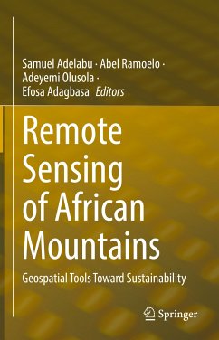
This edited volume focuses on the use of remote sensing techniques to assess and monitor mountainous ecosystems in Africa, with a focus on tracking changes related to climate change and human activity. The book is timely, as the interaction of mountain environmental dynamics with conservation and sustainability is an under-researched issue. The chapters in this volume use remotely sensed data to study a variety of topics related to mountains and their ecosystems, including but not limited to vegetation, energy systems, environmental hazards, ecosystem services, diseases, climatic shifts,…mehr
This edited volume focuses on the use of remote sensing techniques to assess and monitor mountainous ecosystems in Africa, with a focus on tracking changes related to climate change and human activity. The book is timely, as the interaction of mountain environmental dynamics with conservation and sustainability is an under-researched issue. The chapters in this volume use remotely sensed data to study a variety of topics related to mountains and their ecosystems, including but not limited to vegetation, energy systems, environmental hazards, ecosystem services, diseases, climatic shifts, geological formations and geomorphological dynamics. The ability to monitor, assess and analyze mountainous regions is aided by the availability of remote sensing products such as optical and microwave sensors and low-cost unmanned aerial vehicles (UAVs). The works presented here push the frontier of knowledge on mountain studies and will help shape local, national and global assessments and policies, including efforts toward the achievement of the African Agenda 2063. The book will be of interest to researchers and students in remote sensing, geography, ecology and sustainability, as well as to government organizations and conservation specialists.
Prof. Samuel Adelabu is an Associate Professor in the Department of Geography at the University of the Free State, South Africa.
Prof. Abel Ramoelo is the Director of the Centre for Environmental Studies, and Associate Professor at the Department of Geography, Geoinformatics and Meteorology, University of Pretoria. He is also a research fellow at Department of Geography at the University of the Free State, South Africa
Dr. Adeyemi Olusola is a Postdoctoral fellow at the Department of Geography, University of the Free State, Bloemfontein, South Africa and Lecturer in the Department of Geography at the University of Ibadan, Nigeria.
Dr. Efosa Adagbasa is a Lecturer in the Department of Geography at the University of the Free State, South Africa.
Inhaltsangabe
Chapter1. Montane grasslands: Biomass estimations using remote sensing techniques and knowledge gap in Africa.- Chapter2. Unravelling regional Geodiversity: a GRID-MAPPING Approach to QUANTIFY GEODIVERSITY in the uThukela District, KwaZulu-Natal.- Chapter3. Monitoring the wildfire activity and ecosystem response on Mt. Kilimanjaro using Earth Observation data and GIS.- Chapter4. Ecological Vulnerability Assessment to Grassland Fires in a Protected Mountainous Area Using Remote Sensing and GIS.- Chapter5. Natural hazards magnitude, vulnerability and recovery strategies in the Rwenzori Mountains, Southwestern Uganda.- Chapter6. Assessing the Vulnerability of the Eastern Africa Highlands’ Soils to Rainfall Erosivity.- Chapter7. Development of Lightning Hazard Map for Fire Danger Assessment over Mountainous Protected Area using Geospatial Technology.- Chapter8. Water resources monitoring over the Atlas Mountains in Morocco using satellite observations and Reanalysis data.- Chapter9. Evaluating Settlement Development Change, Pre, and Post-1994 in the Drakensberg Mountains of Afromontane Region, South Africa.- Chapter10. Digital Soil Mapping for hydropedological purposes of the Cathedral Peak research catchments, South Africa.- Chapter11. Effect of Climate Variability and Change on Land Suitability for Irish Potato Production in Kigezi Highlands of Uganda.
Chapter1. Montane grasslands: Biomass estimations using remote sensing techniques and knowledge gap in Africa.- Chapter2. Unravelling regional Geodiversity: a GRID-MAPPING Approach to QUANTIFY GEODIVERSITY in the uThukela District, KwaZulu-Natal.- Chapter3. Monitoring the wildfire activity and ecosystem response on Mt. Kilimanjaro using Earth Observation data and GIS.- Chapter4. Ecological Vulnerability Assessment to Grassland Fires in a Protected Mountainous Area Using Remote Sensing and GIS.- Chapter5. Natural hazards magnitude, vulnerability and recovery strategies in the Rwenzori Mountains, Southwestern Uganda.- Chapter6. Assessing the Vulnerability of the Eastern Africa Highlands' Soils to Rainfall Erosivity.- Chapter7. Development of Lightning Hazard Map for Fire Danger Assessment over Mountainous Protected Area using Geospatial Technology.- Chapter8. Water resources monitoring over the Atlas Mountains in Morocco using satellite observations and Reanalysis data.- Chapter9. Evaluating Settlement Development Change, Pre, and Post-1994 in the Drakensberg Mountains of Afromontane Region, South Africa.- Chapter10. Digital Soil Mapping for hydropedological purposes of the Cathedral Peak research catchments, South Africa.- Chapter11. Effect of Climate Variability and Change on Land Suitability for Irish Potato Production in Kigezi Highlands of Uganda.
Es gelten unsere Allgemeinen Geschäftsbedingungen: www.buecher.de/agb
Impressum
www.buecher.de ist ein Internetauftritt der buecher.de internetstores GmbH
Geschäftsführung: Monica Sawhney | Roland Kölbl | Günter Hilger
Sitz der Gesellschaft: Batheyer Straße 115 - 117, 58099 Hagen
Postanschrift: Bürgermeister-Wegele-Str. 12, 86167 Augsburg
Amtsgericht Hagen HRB 13257
Steuernummer: 321/5800/1497