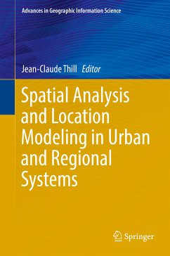
Spatial Analysis and Location Modeling in Urban and Regional Systems (eBook, PDF)
Redaktion: Thill, Jean-Claude
137,95 €
137,95 €
inkl. MwSt.
Sofort per Download lieferbar

69 °P sammeln
137,95 €
Als Download kaufen

137,95 €
inkl. MwSt.
Sofort per Download lieferbar

69 °P sammeln
Jetzt verschenken
Alle Infos zum eBook verschenken
137,95 €
inkl. MwSt.
Sofort per Download lieferbar
Alle Infos zum eBook verschenken

69 °P sammeln
Spatial Analysis and Location Modeling in Urban and Regional Systems (eBook, PDF)
Redaktion: Thill, Jean-Claude
- Format: PDF
- Merkliste
- Auf die Merkliste
- Bewerten Bewerten
- Teilen
- Produkt teilen
- Produkterinnerung
- Produkterinnerung

Bitte loggen Sie sich zunächst in Ihr Kundenkonto ein oder registrieren Sie sich bei
bücher.de, um das eBook-Abo tolino select nutzen zu können.
Hier können Sie sich einloggen
Hier können Sie sich einloggen
Sie sind bereits eingeloggt. Klicken Sie auf 2. tolino select Abo, um fortzufahren.

Bitte loggen Sie sich zunächst in Ihr Kundenkonto ein oder registrieren Sie sich bei bücher.de, um das eBook-Abo tolino select nutzen zu können.
This contributed volume collects cutting-edge research in Geographic Information Science & Technologies, Location Modeling, and Spatial Analysis of Urban and Regional Systems. The contributions emphasize methodological innovations or substantive breakthroughs on many facets of the socio-economic and environmental reality of urban and regional contexts.
- Geräte: PC
- ohne Kopierschutz
- eBook Hilfe
- Größe: 10.7MB
Andere Kunden interessierten sich auch für
![Location Based Services and TeleCartography (eBook, PDF) Location Based Services and TeleCartography (eBook, PDF)]() Location Based Services and TeleCartography (eBook, PDF)161,95 €
Location Based Services and TeleCartography (eBook, PDF)161,95 €![The Practice of Spatial Analysis (eBook, PDF) The Practice of Spatial Analysis (eBook, PDF)]() The Practice of Spatial Analysis (eBook, PDF)113,95 €
The Practice of Spatial Analysis (eBook, PDF)113,95 €![Trends in Spatial Analysis and Modelling (eBook, PDF) Trends in Spatial Analysis and Modelling (eBook, PDF)]() Trends in Spatial Analysis and Modelling (eBook, PDF)81,95 €
Trends in Spatial Analysis and Modelling (eBook, PDF)81,95 €![Geographic Information Metadata for Spatial Data Infrastructures (eBook, PDF) Geographic Information Metadata for Spatial Data Infrastructures (eBook, PDF)]() Javier Nogueras-IsoGeographic Information Metadata for Spatial Data Infrastructures (eBook, PDF)113,95 €
Javier Nogueras-IsoGeographic Information Metadata for Spatial Data Infrastructures (eBook, PDF)113,95 €![Spatial Data Handling in Big Data Era (eBook, PDF) Spatial Data Handling in Big Data Era (eBook, PDF)]() Spatial Data Handling in Big Data Era (eBook, PDF)81,95 €
Spatial Data Handling in Big Data Era (eBook, PDF)81,95 €![Spatial Techniques for Soil Erosion Estimation (eBook, PDF) Spatial Techniques for Soil Erosion Estimation (eBook, PDF)]() Rupesh Jayaram PatilSpatial Techniques for Soil Erosion Estimation (eBook, PDF)53,95 €
Rupesh Jayaram PatilSpatial Techniques for Soil Erosion Estimation (eBook, PDF)53,95 €![Mapping Versatile Boundaries (eBook, PDF) Mapping Versatile Boundaries (eBook, PDF)]() Regis DarquesMapping Versatile Boundaries (eBook, PDF)121,95 €
Regis DarquesMapping Versatile Boundaries (eBook, PDF)121,95 €-
-
-
This contributed volume collects cutting-edge research in Geographic Information Science & Technologies, Location Modeling, and Spatial Analysis of Urban and Regional Systems. The contributions emphasize methodological innovations or substantive breakthroughs on many facets of the socio-economic and environmental reality of urban and regional contexts.
Dieser Download kann aus rechtlichen Gründen nur mit Rechnungsadresse in A, B, BG, CY, CZ, D, DK, EW, E, FIN, F, GR, HR, H, IRL, I, LT, L, LR, M, NL, PL, P, R, S, SLO, SK ausgeliefert werden.
Produktdetails
- Produktdetails
- Verlag: Springer Berlin Heidelberg
- Seitenzahl: 387
- Erscheinungstermin: 30. November 2017
- Englisch
- ISBN-13: 9783642378966
- Artikelnr.: 52998113
- Verlag: Springer Berlin Heidelberg
- Seitenzahl: 387
- Erscheinungstermin: 30. November 2017
- Englisch
- ISBN-13: 9783642378966
- Artikelnr.: 52998113
- Herstellerkennzeichnung Die Herstellerinformationen sind derzeit nicht verfügbar.
Jean-Claude Thill is Knight Distinguished Professor of Public Policy at the University of North Carolina at Charlotte. He received his doctoral degree in Geography from the Université Catholique de Louvain, Louvain-la-Neuve, Belgium. He is the Editor-in-Chief of Computers, Environment and Urban Systems, and serves on the editorial board of a number of international journals in geography, urban science and regional science. He served as President of the Regional Science Association International (RSAI) and has been elected Fellow of RSAI. His research has focused on the spatial organization of socio-economic systems across scales. His recent contributions have involved leveraging spatial data analytics (including GeoComputation) to better apprehend urban and regional systems at a finer spatio-temporal granularity.
Part 1. 1-Innovations in GIS&T, location modeling and spatial analysis. 2-A bayesian interpolation method to estimate per capita GDP at the sub-regional level: local labour markets in Spain. 3-Discovering functional zones in a city using human movements and points of interest. 4-Is your city economic, cultural, or political? recognition of city image based on multidimensional scaling of quantified web pages. 5-Spatial hedonic modeling of housing prices using auxiliary maps. 6-Modeling and simulation of cohesion policy funding and regional growth diffusion in an enlarged European Union. Part 2. 7-Analyzing and simulating urban density: exploring the differences between policy ambitions and actual trends in the Netherlands. 8-A decision support system for farmland preservation: integration of past and present land use. 9-Aggregate and disaggregate dynamic spatial interaction approaches to modeling coin diffusion. 10-Comprehensive evaluation of the regional environmental and socio-economic impacts of adopting advanced technologies for the treatment of sewage sludge in Beijing. Part 3. 11-Locational modeling in spatial analysis: development and maturity of concepts. 12-Spatial uncertainty challenges in location modeling with dispersion requirements. 13-The nearest neighbor ant colony system: a spatially-explicit algorithm for the traveling salesman problem. 14-Large-scale energy infrastructure optimization: breakthroughs and challenges of CO2 capture and storage (CCS) modeling. 15-The recharging infrastructure needs for long distance travel by electric vehicles: a comparison of battery-switching and quick-charging stations. 16-Transport strategies in reverse logistics for establishing a sound material-cycle society.
Part 1. 1-Innovations in GIS&T, location modeling and spatial analysis. 2-A bayesian interpolation method to estimate per capita GDP at the sub-regional level: local labour markets in Spain. 3-Discovering functional zones in a city using human movements and points of interest. 4-Is your city economic, cultural, or political? recognition of city image based on multidimensional scaling of quantified web pages. 5-Spatial hedonic modeling of housing prices using auxiliary maps. 6-Modeling and simulation of cohesion policy funding and regional growth diffusion in an enlarged European Union. Part 2. 7-Analyzing and simulating urban density: exploring the differences between policy ambitions and actual trends in the Netherlands. 8-A decision support system for farmland preservation: integration of past and present land use. 9-Aggregate and disaggregate dynamic spatial interaction approaches to modeling coin diffusion. 10-Comprehensive evaluation of the regional environmental and socio-economic impacts of adopting advanced technologies for the treatment of sewage sludge in Beijing. Part 3. 11-Locational modeling in spatial analysis: development and maturity of concepts. 12-Spatial uncertainty challenges in location modeling with dispersion requirements. 13-The nearest neighbor ant colony system: a spatially-explicit algorithm for the traveling salesman problem. 14-Large-scale energy infrastructure optimization: breakthroughs and challenges of CO2 capture and storage (CCS) modeling. 15-The recharging infrastructure needs for long distance travel by electric vehicles: a comparison of battery-switching and quick-charging stations. 16-Transport strategies in reverse logistics for establishing a sound material-cycle society.
