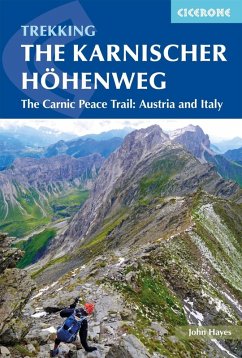
A guidebook to trekking the Karnischer Höhenweg, or Carnic Peace Trail. The 170km hut-to-hut trail follows the World War I front line through the Carnic Alps, along the border of Austria and Italy, and is rich in historical, geological and cultural interest. It can be hiked in 12 weeks and is suitable for walkers with a reasonable level of fitness, a sense of adventure and a head for heights.
The guidebook covers both the Austrian variant, which is presented in 8 day stages, and the Italian variant, presented over 10 days, with stages ranging from 6 to 28km. Also included are optional detours to climb neighbouring peaks, such as Monte Coglians.
The guidebook covers both the Austrian variant, which is presented in 8 day stages, and the Italian variant, presented over 10 days, with stages ranging from 6 to 28km. Also included are optional detours to climb neighbouring peaks, such as Monte Coglians.
- 1:50,000 mapping and elevation profile provided for each stage
- GPX files available to download
- Handy route summary tables help you plan your itinerary
- Accommodation listings included
- Advice on planning and preparation
Dieser Download kann aus rechtlichen Gründen nur mit Rechnungsadresse in A, D ausgeliefert werden.

