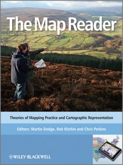
The Map Reader (eBook, PDF)
Theories of Mapping Practice and Cartographic Representation
Redaktion: Dodge, Martin; Perkins, Chris; Kitchin, Rob


Alle Infos zum eBook verschenken

The Map Reader (eBook, PDF)
Theories of Mapping Practice and Cartographic Representation
Redaktion: Dodge, Martin; Perkins, Chris; Kitchin, Rob
- Format: PDF
- Merkliste
- Auf die Merkliste
- Bewerten Bewerten
- Teilen
- Produkt teilen
- Produkterinnerung
- Produkterinnerung

Hier können Sie sich einloggen

Bitte loggen Sie sich zunächst in Ihr Kundenkonto ein oder registrieren Sie sich bei bücher.de, um das eBook-Abo tolino select nutzen zu können.
WINNER OF THE CANTEMIR PRIZE 2012 awarded by the Berendel Foundation The Map Reader brings together, for the first time, classic and hard-to-find articles on mapping. This book provides a wide-ranging and coherent edited compendium of key scholarly writing about the changing nature of cartography over the last half century. The editorial selection of fifty-four theoretical and thought provoking texts demonstrates how cartography works as a powerful representational form and explores how different mapping practices have been conceptualised in particular scholarly contexts. Themes covered…mehr
- Geräte: PC
- mit Kopierschutz
- eBook Hilfe
- Größe: 14.28MB
![Innovative Software Development in GIS (eBook, PDF) Innovative Software Development in GIS (eBook, PDF)]() Innovative Software Development in GIS (eBook, PDF)140,99 €
Innovative Software Development in GIS (eBook, PDF)140,99 €![Computer Processing of Remotely-Sensed Images (eBook, PDF) Computer Processing of Remotely-Sensed Images (eBook, PDF)]() Paul M. MatherComputer Processing of Remotely-Sensed Images (eBook, PDF)60,99 €
Paul M. MatherComputer Processing of Remotely-Sensed Images (eBook, PDF)60,99 €![The Map Reader (eBook, ePUB) The Map Reader (eBook, ePUB)]() The Map Reader (eBook, ePUB)104,99 €
The Map Reader (eBook, ePUB)104,99 €![Laser Scanning for the Environmental Sciences (eBook, PDF) Laser Scanning for the Environmental Sciences (eBook, PDF)]() Laser Scanning for the Environmental Sciences (eBook, PDF)104,99 €
Laser Scanning for the Environmental Sciences (eBook, PDF)104,99 €![GIS and Crime Mapping (eBook, PDF) GIS and Crime Mapping (eBook, PDF)]() Spencer ChaineyGIS and Crime Mapping (eBook, PDF)63,99 €
Spencer ChaineyGIS and Crime Mapping (eBook, PDF)63,99 €![Teaching Geographic Information Science and Technology in Higher Education (eBook, PDF) Teaching Geographic Information Science and Technology in Higher Education (eBook, PDF)]() Teaching Geographic Information Science and Technology in Higher Education (eBook, PDF)107,99 €
Teaching Geographic Information Science and Technology in Higher Education (eBook, PDF)107,99 €![Self-Organising Maps (eBook, PDF) Self-Organising Maps (eBook, PDF)]() Self-Organising Maps (eBook, PDF)141,99 €
Self-Organising Maps (eBook, PDF)141,99 €-
-
-
Dieser Download kann aus rechtlichen Gründen nur mit Rechnungsadresse in A, B, BG, CY, CZ, D, DK, EW, E, FIN, F, GR, HR, H, IRL, I, LT, L, LR, M, NL, PL, P, R, S, SLO, SK ausgeliefert werden.
- Produktdetails
- Verlag: John Wiley & Sons
- Seitenzahl: 504
- Erscheinungstermin: 6. April 2011
- Englisch
- ISBN-13: 9780470979594
- Artikelnr.: 37301132
- Verlag: John Wiley & Sons
- Seitenzahl: 504
- Erscheinungstermin: 6. April 2011
- Englisch
- ISBN-13: 9780470979594
- Artikelnr.: 37301132
- Herstellerkennzeichnung Die Herstellerinformationen sind derzeit nicht verfügbar.
Preface xix
Acknowledgements xxv
Colour Plate One: Cartographic Production (On the inside front cover)
Section One Conceptualising Mapping 1
1.1 Introductory Essay: Conceptualising Mapping, by Rob Kitchin, Martin
Dodge and Chris Perkins 2
1.2 General Theory, from Semiology of Graphics, by Jacques Bertin 8
The first formal specification for semiotic rules controlling the
representation of different kinds of information in a graphical form.
1.3 On Maps and Mapping, from The Nature of Maps: Essays Toward
Understanding Maps and Mapping, by Arthur H. Robinson and Barbara B.
Petchenik 17
An important contribution to the status of maps and mapping reflecting on
the need for cognitive and perceptual approaches to map design and
cartography as visual communication.
1.4 The Science of Cartography and its Essential Processes, by Joel L.
Morrison 24
An overview of cartography as communications science and justification for
a progressive and experimental approach.
1.5 Analytical Cartography, by Waldo R. Tobler 32
An early call for a rethinking of cartography deploying a more analytical
approach grounded in theory and deploying mathematical principles.
1.6 Cartographic Communication, by Christopher Board 37
One of the most complete discussions of the communications paradigm and the
role of modelling the flow of cartographic information.
1.7 Design on Signs / Myth and Meaning in Maps, by Denis Wood and John Fels
48
A structuralist reading of cartography as a sign system exploring how codes
operate to naturalise the cultural work of the map.
1.8 Deconstructing the Map, by J.B. Harley 56
An influential call for a more engaged, critical and social constructivist
approach to mapping drawing upon notions of the map as a form of power
knowledge.
1.9 Drawing Things Together, by Bruno Latour 65
Argues that visualisations play central roles in the practices of knowledge
construction and establishes how the map might function as an immutable
mobile.
1.10 Cartography Without 'Progress': Reinterpreting the Nature and
Historical Development of Mapmaking, by Matthew H. Edney 73
Argues for an anti-progressive view of cartography as an assemblage in
which different modes of knowing the world emerge from local contexts.
1.11 Exploratory Cartographic Visualisation: Advancing the Agenda, by Alan
M. MacEachren and Menno-Jan Kraak 83
Sets out a research agenda for a more exploratory and interactive mapping
emerging from technological and epistemological change of the early 1990s.
1.12 The Agency of Mapping: Speculation, Critique and Invention, by James
Corner 89
A persuasive argument for the creative and emancipatory potential of
mapping as a set of practices exemplified by work in architecture and
planning.
1.13 Beyond the 'Binaries': A Methodological Intervention for Interrogating
Maps as Representational Practices, by Vincent J. Del Casino Jr. and
Stephen P. Hanna 102
A call to move beyond orthodox binary thinking and to adopt a more
performative approach to mapping informed by feminist critiques.
1.14 Rethinking Maps, by Rob Kitchin and Martin Dodge 108
Rejects the idea of mapping as ontic knowledge, focusing instead upon its
processual and emergent qualities as a context-dependant and relational
problem solving technology.
Colour Plate Two: Mapping the Internet
Section Two Technologies of Mapping 115
2.1 Introductory Essay: Technologies of Mapping, by Martin Dodge, Rob
Kitchin and Chris Perkins 116
2.2 A Century of Cartographic Change, from Technological Transition in
Cartography, by Mark S. Monmonier 122
A progressive overview of technological change in the first eight decades
of the twentieth century, focusing upon the nature, combinations and rates
of change in mapmaking.
2.3 Manufacturing Metaphors: Public Cartography, the Market, and Democracy,
by Patrick H. McHaffie 129
Charts the connections between technological change and the labour process
in the context of mass production of official mapping.
2.4 Maps and Mapping Technologies of the Persian Gulf War, by Keith C.
Clarke 134
Explores the impacts of war on mapping technologies through a case study on
United States military activity in the first gulf war.
2.5 Automation and Cartography, by Waldo R. Tobler 137
A pioneering consideration of the potential of using the computer in map
data, storage analysis output and display.
2.6 Cartographic Futures on a Digital Earth, by Michael F. Goodchild 141
A view from the late 1990s reflecting upon the power of digital technology
to widen access to mapping but also diminish traditional visual
cartographic skills.
2.7 Cartography and Geographic Information Systems, by Phillip C. Muehrcke
147
Explores the emerging relationship between the map and GIS and considers
what remains unmappable with GI technologies.
2.8 Remote Sensing of Urban/Suburban Infrastructure and Socio-Economic
Attributes, by John R. Jensen and Dave C. Cowen 153
Considers how remotely-sensed technologies can supplement more traditional
urban mapping practices.
2.9 Emergence of Map Projections, from Flattening the Earth: Two Thousand
Years of Map Projections, by John P. Synder 164
An overview of the changing form and deployment of map projections
reflecting on the flexibility of computer processing facilitating diverse
choices, but also the continuing limits on appropriate use.
2.10 Mobile Mapping: An Emerging Technology for Spatial Data Acquisition,
by Rongxing li 170
A paper from the late 1990s illustrating the potential of mobile data
collection methods subsequently realised in consumer services like Google
Street View.
2.11 Extending the Map Metaphor Using Web Delivered Multimedia, by William
Cartwright 178
An illustration of how multi-mediated interaction can deliver new kinds of
information design in game like and hyper-linked interfaces.
2.12 Imaging the World: The State of Online Mapping, by Tom Geller 185
Provides a snapshot of the state of mass interactive mappingon-demand
served from online corporate portals and community projects.
Colour Plate Three: Pictorial Mapping
Section Three Cartographic Aesthetics and Map Design 193
3.1 Introductory Essay: Cartographic Aesthetics and Map Design, by Chris
Perkins, Martin Dodge and Rob Kitchin 194
3.2 Interplay of Elements, from Cartographic Relief Presentation, by
Eduard Imhof 201
Discusses the importance of relationship between visual forms in the design
of topographic mapping, with a particular focus on challenges of mountain
cartography.
3.3 Cartography as a Visual Technique, from The Look of Maps, by Arthur H.
Robinson 215
Justifies the need for a visual approach to mapping, focusing in particular
upon the design of thematic maps.
3.4 Generalisation in Statistical Mapping, by George F. Jenks 219
A consideration of the impacts of different kinds of generalization and
classification on the patterns presented in quantitative cartography.
3.5 Strategies for the Visualisation of Geographic Time-Series Data, by
Mark Monmonier 231
An early classification and conceptual framework for the consideration of
mapping that simultaneously depicts time and space in an effective manner.
3.6 The Roles of Maps, from Some Truth with Maps: A Primer on Symbolization
and Design, by Alan M. MacEachren 244
Reflects on the roles of design in decision making in the era of data
exploration, confirmation, synthesis and presentation.
3.7 Area Cartograms: Their Use and Creation, by Daniel Dorling 252
Discusses the history design and use of different kinds of cartograms with
a particular focus on their potential in mapping socio-economic and
political data.
3.8 ColorBrewer.org: An Online Tool for Selecting Colour Schemes for Maps,
by Mark Harrower and Cynthia A. Brewer 261
Describes the development and potential of an online tool for guiding
appropriate selection of colour schemes for the representation of
quantitative data in choropleth mapping.
3.9 Maps, Mapping, Modernity: Art and Cartography in the Twentieth Century,
by Denis Cosgrove 269
Charts relations between art and mapping in the early twentieth century
highlighting ongoing collaboration in a period when orthodox views
suggested separate practices.
3.10 Affective Geovisualisations, by Stuart Aitken and James Craine 278
Highlights what can be learnt from film and suggests geovisualisations
should engage more with affect and emotion.
3.11 Egocentric Design of Map-Based Mobile Services, by Liqiu Meng 281
Focuses on the design requirements for short-term and transient images
revealed in egocentric displays that characterise map-based mobile
services.
3.12 The Geographic Beauty of a Photographic Archive, by Jason Dykes and
Jo Wood 288
Explores how the beauty of data can be revealed through the creative
deployment of treemaps in an analysis the Geograph data set.
Colour Plate Four: Visualising Cartographic Colour Schemes and Mapping
Spatial Information Space
Section Four Cognition and Cultures of Mapping 297
4.1 Introductory Essay: Cognition and Cultures of Mapping, by Chris Perkins
, Rob Kitchin and Martin Dodge 298
4.2 Map Makers are Human: Comments on the Subjective in Maps, by John K.
Wright 304
An influential and early clarion call for research into the roles people
and their subjectivities play in the mapping process.
4.3 Cognitive Maps and Spatial Behaviour: Process and Products, by Roger M.
Downs and David Stea 312
An overview of behavioural geographic understanding of cognitive mapping
that argues for the need for experimental investigation and establishes
basic principles.
4.4 Natural Mapping, by James M. Blaut 318
Provides an argument and empirical evidence for a cross cultural
development of map skill acquisition, especially in children.
4.5 The Map as Biography: Thoughts on Ordnance Survey Map, Six-Inch Sheet
Devonshire CIX, SE, Newton Abbot, by J.B. Harley 327
A personal reflection on the interplay between a single historic
topographic survey sheet and the ways it narrates different biographical
associations with place.
4.6 Reading Maps, by Eileen Reeves 332
An exploration of the cultural meanings attached to cartography through the
map reading process that tracks the shift from a textual to visual view of
the medium and considers the gendering of maps.
4.7 Mapping Reeds and Reading Maps: The Politics of Representation in Lake
Titicaca, by Benjamin S. Orlove 339
A social anthropological consideration of tensions, actions and discourses
involved in a local resource conflict and how maps and mapping are enrolled
into cultural politics.
4.8 Refiguring Geography: Parish Maps of Common Ground, by David Crouch
and David Matless 354
A reflection on how place emerges through a community mapping project which
highlights the interplay of politics, aesthetics and practice.
4.9 Understanding and Learning Maps, by Robert Lloyd 362
An overview of changing trajectories of cognitive map research charting
development from early psychophysical experiments to more nuanced
theoretical work.
4.10 Citizens as Sensors: The World of Volunteered Geography, by Michael F.
Goodchild 370
Describes and explains the nature and emergence of crowdsourced mapping and
assesses its potential contribution to the social production of
cartography.
4.11 Usability Evaluation of Web Mapping Sites, by Annu-Maaria Nivala,
Stephen Brewster and L. Tiina Sarjakoski 379
Provides an empirical comparison of web mapping portals illustrating the
potential of usability engineering as a tool to evaluate and improve
interface design.
Colour Plate Five: Visualising the Efforts of Volunteer Cartographers
Section Five Power and Politics of Mapping 387
5.1 Introductory Essay: Power and Politics of Mapping, by Rob Kitchin,
Martin Dodge and Chris Perkins 388
5.2 The Time and Space of the Enlightenment Project, from The Condition of
Postmodernity, by David Harvey 395
An historical analysis of perspectivism and Cartesian rationality in
cartography which facilitated capital accumulation.
5.3 Texts, Hermeneutics and Propaganda Maps, by John Pickles 400
A textual approach to cartographic power focusing on an interpretive case
study of the cultural work of propaganda maps.
5.4 Mapping: A New Technology of Space; Geo-Body, from Siam Mapped: A
History of the Geo-Body of a Nation, by Thongchai Winichakul 407
An insightful case study exploring the constitutive role of maps in the
making of imaginative geographies of nationhood.
5.5 First Principles of a Literary Cartography, from Territorial Disputes:
Maps and Mapping Strategies in Contemporary Canadian and Australian
Fiction, by Graham Huggan 412
Examines the potential of cartography to control, but reminds us of the
destabilising potential of maps in feminist and ethnic literature, serving
as both texts and textual events.
5.6 Whose Woods are These? Counter-Mapping Forest Territories in
Kalimantan, Indonesia, by Nancy Lee Peluso 422
Discusses how state interests deploy mapping as a powerful discourse, but
also reveals the potential of counter-mapping by NGOs and local people.
5.7 A Map that Roared and an Original Atlas: Canada, Cartography, and the
Narration of Nation, by Matthew Sparke 430
A postcolonial approach to maps as contra-punctual moments in the struggle
for identity and space, developed through an analysis of Canadian mapping
encounters.
5.8 Cartographic Rationality and the Politics of Geosurveillance and
Security, by Jeremy W. Crampton 440
An historical analysis of the role of mapping as a surveillant technology
deployed as part of governmental regimes to rationalise and discipline
citizens.
5.9 Affecting Geospatial Technologies: Toward a Feminist Politics of
Emotion, by Mei-Po Kwan 448
Argues for a vision of geo-spatial technologies informed by feminist ideas
and notions of affect, that incorporates an emotional and embodied approach
to mapping practices.
5.10 Queering the Map: The Productive Tensions of Colliding Epistemologies,
by Michael Brown and Larry Knopp 456
Explores the tensions between queer geographies and Cartesian rationality,
revealed in ontological and epistemological differences in a community
mapping project.
5.11 Mapping the Digital Empire: Google Earth and the Process of Postmodern
Cartography, by Jason Farman 464
An exploration of the emancipatory potential of Web 2.0 interfaces,
reflecting on the remaking of corporate power embodied in newly
crowd-sourced alternative mappings.
Colour Plate Six: Cartographies of Protest (On the inside back cover)
Index 471
"It is compulsory reading for 'students, academics and lay readers interested in understanding the appeal and power of maps'. It deserves a wide reading audience." (Int. J. Environment and Pollution, 1 October 2013)
"But for anyone who wants to get the most out of a map, whatever medium it is in, it is fascinating. It is a text-book for map readers, written by map-makers". (Law Society Journal, 1 October 2011)
"I highly recommend the landmark anthology The Map Reader: Theories of Mapping Practice and Cartographic Representation edited by Martin Dodge, Rob Kitchin, and Chris Perkins, to any students, researchers, and interested non-professionals in the areas of cartography, mapping technology, GIScience, social sciences, the media, the visual arts, and industry who are seeking a complete resource on the topic of map making. The articles cover every aspect of this rapidly changing field, written by leading scholars in many very diverse disciplines." (Blog Business World, 2 October 2011)
"Written as a comprehensive guide to cover all of these disciplines The Map Reader ensures that the most important cartographic ideas are made available to researchers, students and cartography enthusiast alike." (PhysOrg.com, 25 May 2011)…mehr
