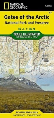
This Trails Illustrated map for Gates of the Arctic National Park and Preserve and surrounding area in northern Alaska is perfect for hiking, camping, exploring, photography, and wildlife viewing in this stunning expanse. This two-sided map includes Gates of the Arctic National Park and Preserve in its entirety, portions of Noatak National Preserve, Kanuti National Wildlife Refuge, Selawik National Wildlife Refuge, and Yukon Flats National Wildlife Refuge. Also included are Anaktuvuk Pass, Mount Ingstad, Bettles / Evansville, Gobblers Knob, Coldfoot, the Arctic Interagency Visitor Center, South Fork Koyukuk River, Grayling Lake, Marion Creek Campground, Wiseman, Sukiakpak Mountain, Brooks Range, the Endicott Mountains, Noatak Wild and Scenic River, Alatna Wild and Scenic River, John Wild and Scenic River, Kobuk Wild and Scenic River, Tinayguk Wild and Scenic River, Koyukuk Wild and Scenic River, Walker Lake, Nutuyukti Lake, Norutak Lake, Wild Lake, and more. The second side of the map features a beautiful map of Alaska with all of its national parks and preserves, as well as detailed information about Gates of the Arctic National Park and Preserve, trip planning tips, backcountry activities and safety informatioon, and special information about the beautiful part of the world. UTM grids have also been added to make it more usable with your GPS. Includes UTM grids for use with your GPS unit.
Hinweis: Dieser Artikel kann nur an eine deutsche Lieferadresse ausgeliefert werden.
Hinweis: Dieser Artikel kann nur an eine deutsche Lieferadresse ausgeliefert werden.


![Lake Tahoe Basin Map [Us Forest Service] Lake Tahoe Basin Map [Us Forest Service]](https://bilder.buecher.de/produkte/26/26439/26439593m.jpg)

![Black Hills North Map [Black Hills National Forest] Black Hills North Map [Black Hills National Forest]](https://bilder.buecher.de/produkte/32/32875/32875913m.jpg)

