16,99 €
inkl. MwSt.

Versandfertig in über 4 Wochen
  • Landkarte

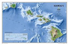
One of Expertly researched and designed, National Geographic's most visually stunning maps, the Hawai'i Map shows all eight of the major islands and includes an inset of the entire chain of reefs stretching nearly 3,000 miles across the central Pacific. In addition to showing all of the major land features, the map also shows the Hawaiian Ridge that runs under the islands, providing a wonderful perspective on how they were formed. The map is packaged in a two inch diameter tube with a label showing a thumbnail of the map with dimensions and other pertinent information. * Map Scale = 1:819,000 * Sheet Size = 34.75" x 22.75"…mehr

Produktbeschreibung
One of Expertly researched and designed, National Geographic's most visually stunning maps, the Hawai'i Map shows all eight of the major islands and includes an inset of the entire chain of reefs stretching nearly 3,000 miles across the central Pacific. In addition to showing all of the major land features, the map also shows the Hawaiian Ridge that runs under the islands, providing a wonderful perspective on how they were formed. The map is packaged in a two inch diameter tube with a label showing a thumbnail of the map with dimensions and other pertinent information. * Map Scale = 1:819,000 * Sheet Size = 34.75" x 22.75"
Autorenporträt
Founded in 1915 as the Cartographic Group, the first division of National Geographic, National Geographic Maps has been responsible for illustrating the world around us through the art and science of mapmaking.Today, National Geographic Maps continues this mission by creating the world's best wall maps, recreation maps, atlases, and globes which inspire people to care about and explore their world.