- Broschiertes Buch
- Merkliste
- Auf die Merkliste
- Bewerten Bewerten
- Teilen
- Produkt teilen
- Produkterinnerung
- Produkterinnerung
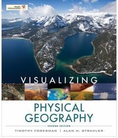
With its unique approach, Visualizing Physical Geography 2nd Edition captures the reader's attention and demonstrates why physical geography is relevant to them. It relies heavily on the integration of National Geographic and other visuals with narrative to explore key concepts.
Andere Kunden interessierten sich auch für
![Geography for Dummies Geography for Dummies]() Jerry T. MitchellGeography for Dummies29,99 €
Jerry T. MitchellGeography for Dummies29,99 €![Decolonizing Geography Decolonizing Geography]() Sarah A. RadcliffeDecolonizing Geography27,99 €
Sarah A. RadcliffeDecolonizing Geography27,99 €![Mindset Mathematics: Visualizing and Investigating Big Ideas, Grade 6 Mindset Mathematics: Visualizing and Investigating Big Ideas, Grade 6]() Jo BoalerMindset Mathematics: Visualizing and Investigating Big Ideas, Grade 630,99 €
Jo BoalerMindset Mathematics: Visualizing and Investigating Big Ideas, Grade 630,99 €![Mindset Mathematics: Visualizing and Investigating Big Ideas, Grade 7 Mindset Mathematics: Visualizing and Investigating Big Ideas, Grade 7]() Jo BoalerMindset Mathematics: Visualizing and Investigating Big Ideas, Grade 730,99 €
Jo BoalerMindset Mathematics: Visualizing and Investigating Big Ideas, Grade 730,99 €![Mindset Mathematics: Visualizing and Investigating Big Ideas, Grade 3 Mindset Mathematics: Visualizing and Investigating Big Ideas, Grade 3]() Jo BoalerMindset Mathematics: Visualizing and Investigating Big Ideas, Grade 328,99 €
Jo BoalerMindset Mathematics: Visualizing and Investigating Big Ideas, Grade 328,99 €![Urban Geography Urban Geography]() David Kaplan (Case Western Reserve Univers Department of PathologyUrban Geography133,99 €
David Kaplan (Case Western Reserve Univers Department of PathologyUrban Geography133,99 €![Volcanoes Volcanoes]() John P. LockwoodVolcanoes98,99 €
John P. LockwoodVolcanoes98,99 €-
-
-
With its unique approach, Visualizing Physical Geography 2nd Edition captures the reader's attention and demonstrates why physical geography is relevant to them. It relies heavily on the integration of National Geographic and other visuals with narrative to explore key concepts.
Hinweis: Dieser Artikel kann nur an eine deutsche Lieferadresse ausgeliefert werden.
Hinweis: Dieser Artikel kann nur an eine deutsche Lieferadresse ausgeliefert werden.
Produktdetails
- Produktdetails
- Visualizing Series
- Verlag: John Wiley & Sons Inc
- 2 ed
- Seitenzahl: 624
- Erscheinungstermin: 11. Januar 2012
- Englisch
- Abmessung: 283mm x 235mm x 20mm
- Gewicht: 1376g
- ISBN-13: 9780470626153
- ISBN-10: 0470626151
- Artikelnr.: 33869168
- Herstellerkennzeichnung
- Libri GmbH
- Europaallee 1
- 36244 Bad Hersfeld
- gpsr@libri.de
Tim Foresman earned his Ph.D. degree in Geography from the University of California at Santa Barbara. He is adjunct Professor of Geography at University of Maryland and president of the International Center for Remote Sensing Education. He has over 100 professional articles and books on environmental protection and sustainable development using the applied tools of geography, including remote sensing and geographic information systems (GIS). His pioneering work in spatial information systems and geographic information systems includes a seminal publication on the history of GIS and a Lifetime Achievement Award from ESRI. His active research and field studies have included tenure with the US Department of Defense, US Environmental Protection Agency, NASA, and the United Nations Environment Programme. His international recognition includes service as adjunct professor at Coventry University in England and Qinghai University in China, as well as visiting professor at Keio University in Japan. He was elected as Fellow of Sigma Xi, the scientific research society Alan Strahler earned his Ph.D. degree in Geography from Johns Hopkins in 1969, and is presently Professor of Geography at Boston University. He has published over 250 articles in the refereed scientific literature, largely on the theory of remote sensing of vegetation, and has also contributed to the fields of plant geography, forest ecology, and quantitative methods. In 2011, he received the Pecora Award from the US Geological Survey and the American Society of Photogrammetry and Remote Sensing in recognition of his work in remote sensing. He has also been awarded the Association of American Geographers/Remote Sensing Specialty Group Medal for Outstanding Contributions to Remote Sensing. With Arthur Strahler, he is a coauthor of seven textbook titles with twelve revised editions on physical geography and environmental science. He holds the honorary degree D.S.H.C. from the Université Catholique de Louvain, Belgium, and is a Fellow of the American Association for the Advancement of Science.
Preface
1 Discovering the Earth's Dimensions
2 The Earth's Global Energy Balance
3 Air Temperature
4 Atmospheric Moisture and Precipitation
5 Global Atmospheric and Oceanic Circulation
6 Weather Systems
7 Global Climates and Climate Change
8 Earth from the Inside Out
9 Plate Tectonics, Earthquakes, and Volcanoes
10 Weathering and Mass Wasting
11 Fresh Water of the Continents
12 Landforms Made by Running Water
13 Landforms Made by Wind and Waves
14 Glacial and Periglacial Landforms
15 Global Soils
16 Biogeographic Processes
17 Global Biogeography
Appendix:
Answers to Self-Tests
Glossary
References
Text, Table and Line Art Credits
Photo Credits
Index

