Learning GeoSpatial Analysis with Python An effective guide to geographic information systems and remote sensing analysis using Python 3
-
- Taschenbuch ausgewählt
- eBook
-
Sprache:Englisch
-
Verlag:Packt Publishing
- Packt Publishing 72,99 €
- Packt Publishing 72,99 € ausgewählt
72,99 €
inkl. gesetzl. MwSt.,
Lieferung nach Hause
Beschreibung
Produktdetails
Einband
Taschenbuch
Erscheinungsdatum
28.12.2015
Verlag
Packt PublishingSeitenzahl
394
Maße (L/B/H)
23,5/19,1/2,2 cm
Gewicht
733 g
Sprache
Englisch
ISBN
978-1-78355-242-9
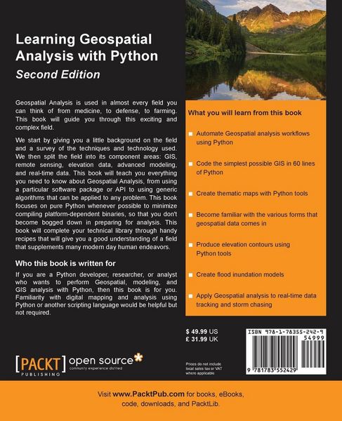
An effective guide to geographic information systems and remote sensing analysis using Python 3 Key Features:Construct applications for GIS development by exploiting Python This focuses on built-in Python modules and libraries compatible with the Python Packaging Index distribution system-no compiling of C libraries necessary This practical, hands-on tutorial teaches you all about Geospatial analysis in Python Book Description: Geospatial Analysis is used in almost every field you can think of from medicine, to defense, to farming. This book will guide you gently into this exciting and complex field. It walks you through the building blocks of geospatial analysis and how to apply them to influence decision making using the latest Python software. Learning Geospatial Analysis with Python, 2nd Edition uses the expressive and powerful Python 3 programming language to guide you through geographic information systems, remote sensing, topography, and more, while providing a framework for you to approach geospatial analysis effectively, but on your own terms. We start by giving you a little background on the field, and a survey of the techniques and technology used. We then split the field into its component specialty areas: GIS, remote sensing, elevation data, advanced modeling, and real-time data. This book will teach you everything you need to know about, Geospatial Analysis from using a particular software package or API to using generic algorithms that can be applied. This book focuses on pure Python whenever possible to minimize compiling platform-dependent binaries, so that you don't become bogged down in just getting ready to do analysis. This book will round out your technical library through handy recipes that will give you a good understanding of a field that supplements many a modern day human endeavors. What You Will Learn:Automate Geospatial analysis workflows using Python Code the simplest possible GIS in 60 lines of Python Mold thematic maps with Python tools Get hold of the various forms that geospatial data comes in Produce elevation contours using Python tools Create flood inundation models Apply Geospatial analysis to find out about real-time data tracking and for storm chasing Who this book is for: If you are a Python developer, researcher, or analyst who wants to perform Geospatial, modeling, and GIS analysis with Python, then this book is for you. Familarity with digital mapping and analysis using Python or another scripting language for automation or crunching data manually is appreciated
Kundinnen und Kunden meinen
Verfassen Sie die erste Bewertung zu diesem Artikel
Helfen Sie anderen Kund*innen durch Ihre Meinung
Kurze Frage zu unserer Seite
Vielen Dank für dein Feedback
Wir nutzen dein Feedback, um unsere Produktseiten zu verbessern. Bitte habe Verständnis, dass wir dir keine Rückmeldung geben können. Falls du Kontakt mit uns aufnehmen möchtest, kannst du dich aber gerne an unseren Kund*innenservice wenden.
zum Kundenservice